Archive for December 12th, 2016
How do you share directions from Google Maps
by admin on Dec.12, 2016, under 3D Models, Argentina, Australia, Brazil, California, Denmark, England, Germany, Google Earth News, Google Earth Tips, Google Sky, Google maps, Hawaii, Indonesia, Ireland, Italy, Japan, Kenya, Mexico, Natural Landmarks, Netherlands, Sightseeing, Street Views, USA, Uncategorized
Google Maps is a very helpful tool. Thanks to the power of technology and internet, people no longer have to suffer getting lost on the road or having difficulty in using a map and compass.
For companies, having a Google Maps embedded on their website is a very beneficial. Their clients can easily track their store locations and other branches. Other people can also use Google Maps for their website. If you want to share or embed Google Maps in a website or blog, here are the steps that you should follow:
1. Open Google Maps by going to https://www.google.com/maps.
2. Search for the location that you want to share. Note that the map, Street View image, or directions should be shown on the map so you can embed it.
3. You will see the Menu at the top left corner of the image:

4. From the Menu, click the ‘Share or Embed map’ option.

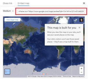
5. In the box that will appear, chose ‘Embed map’ located at the top.

6. You can choose the size that you want to embed in your website or blog. It can be small, medium, large, and you can even customize it.

7. After choosing the size, copy the HTML embed code. In your website or blog, paste it into the source code.
You need to remember that there are limitations in using the Google Maps on your website. If you are using Maps in Lite mode, you can’t embed a map. Furthermore, the traffic information and Maps info might not be accessible on the map that you will embed.
There are also things that you can and cannot share using Google Maps. Some of the thing that can be shared includes a place, business, or address; a directions search; and a Street View image. On the other hand, you can’t share things, such as private details like a map with your saved locations; maps with distance measurements; and a screenshot or image of the map itself.
Aside from using as a tool to search for directions, there are several ways that people can use the Google Maps.
• Save addresses
• Drop a pin to view the streets
• Quickly start GPS navigation
• Get more information about business establishments
• Rate your favorite spots
• The Google Earth Weather feature lets you know the weather patterns all over the world.
• Track your location history
• F-Secure BotNet Mapping
• Let’s photographers know about “The Golden Hour.”
Slow down Google
by sashafromdonetsk on Dec.12, 2016, under 3D Models, Argentina, Australia, Brazil, California, Denmark, England, Germany, Google Earth News, Google Earth Tips, Google Sky, Google maps, Hawaii, Indonesia, Ireland, Italy, Japan, Kenya, Mexico, Natural Landmarks, Netherlands, Sightseeing, Street Views, USA
Global surface water and historical changes map
by Timothy Whitehead on Dec.12, 2016, under 3D Models, Argentina, Australia, Brazil, California, Denmark, England, Germany, Google Earth News, Google Earth Tips, Google Sky, Google maps, Hawaii, Indonesia, Ireland, Italy, Japan, Kenya, Mexico, Natural Landmarks, Netherlands, Sightseeing, Street Views, USA
The science journal Nature recently published an article about mapping long term global surface water using the archive of Landsat and Sentinel imagery using Google Earth Engine. You can read more about it here. This is the same data that was used to create the global historical mosaics that Google recently added to Google Earth but processed to show areas with surface water.
The data has been made freely available via the Global Surface Water Explorer. Sadly, we could not find a way to view the data in Google Earth. There is, however, mention in the ‘download’ options that the data will be made available via ‘web mapping services’, at which point we could make it available for Google Earth in a similar way to what we did with the Mapzen Altitude Tileset
There are a number of options well worth exploring, such as seasonal changes, changes over the last 32 years, various combinations of those and more.

The Brahmaputra River, Bangladesh, which we recently noted changes quite dramatically over time.

The slow death of Great Salt Lake, Utah, looks like a murder scene or an abstract painting.

Toshka Lakes near the Aswan Dam in Egypt is a totally new water body.
Also note that one of the ‘background map’ options is to turn on ‘Earth time-lapse’ animation.
The post Global surface water and historical changes map appeared first on Google Earth Blog.
Paparazzi in LA
by sashafromdonetsk on Dec.12, 2016, under 3D Models, Argentina, Australia, Brazil, California, Denmark, England, Germany, Google Earth News, Google Earth Tips, Google Sky, Google maps, Hawaii, Indonesia, Ireland, Italy, Japan, Kenya, Mexico, Natural Landmarks, Netherlands, Sightseeing, Street Views, USA