Tag: satellite imagery
Hawaii’s Kilauea lava flows
by Timothy Whitehead on Nov.21, 2014, under 3D Models, Argentina, Australia, Brazil, California, Denmark, England, Germany, Google Earth News, Google Earth Tips, Google Sky, Google maps, Hawaii, Indonesia, Ireland, Italy, Japan, Kenya, Mexico, Natural Landmarks, Netherlands, Sightseeing, Street Views, USA
The imagery from Google’s November 8th update is now available in historical imagery. A significant proportion of the imagery was not put into the default imagery, so was not accessible until now.
The location we will look at today is Pāhoa, Hawaii. The default imagery contains a mixture of images, with the most recent addition at first appearing to be cut out in rather odd shapes. But now we have the full original photo in historical imagery we can see that the reason for this is the large amount of cloud cover in the photo.
The reason the image was added at all is because of an ongoing lava flow from the nearby volcano Kilauea and Google have tried to strike a balance between the importance of up to date imagery with cloud cover, and older imagery of better quality. For more on the story, including pictures and video, see here. For more ground level pictures see here. To fly to the location in Google Earth, use this KML file.

Lava flow approaching Pāhoa, Hawaii.

If you look closer you can see wisps of smoke rising from the edges of the flow where it is burning the surrounding vegetation.
The post Hawaii’s Kilauea lava flows appeared first on Google Earth Blog.
Hawaii’s Kilauea lava flows
by Timothy Whitehead on Nov.21, 2014, under 3D Models, Argentina, Australia, Brazil, California, Denmark, England, Germany, Google Earth News, Google Earth Tips, Google Sky, Google maps, Hawaii, Indonesia, Ireland, Italy, Japan, Kenya, Mexico, Natural Landmarks, Netherlands, Sightseeing, Street Views, USA
The imagery from Google’s November 8th update is now available in historical imagery. A significant proportion of the imagery was not put into the default imagery, so was not accessible until now.
The location we will look at today is Pāhoa, Hawaii. The default imagery contains a mixture of images, with the most recent addition at first appearing to be cut out in rather odd shapes. But now we have the full original photo in historical imagery we can see that the reason for this is the large amount of cloud cover in the photo.
The reason the image was added at all is because of an ongoing lava flow from the nearby volcano Kilauea and Google have tried to strike a balance between the importance of up to date imagery with cloud cover, and older imagery of better quality. For more on the story, including pictures and video, see here. For more ground level pictures see here. To fly to the location in Google Earth, use this KML file.
Lava flow approaching Pāhoa, Hawaii.
If you look closer you can see wisps of smoke rising from the edges of the flow where it is burning the surrounding vegetation.
The post Hawaii’s Kilauea lava flows appeared first on Google Earth Blog.
Fake photo of MH17 being shot down
by Timothy Whitehead on Nov.17, 2014, under 3D Models, Argentina, Australia, Brazil, California, Denmark, England, Germany, Google Earth News, Google Earth Tips, Google Sky, Google maps, Hawaii, Indonesia, Ireland, Italy, Japan, Kenya, Mexico, Natural Landmarks, Netherlands, Sightseeing, Street Views, USA
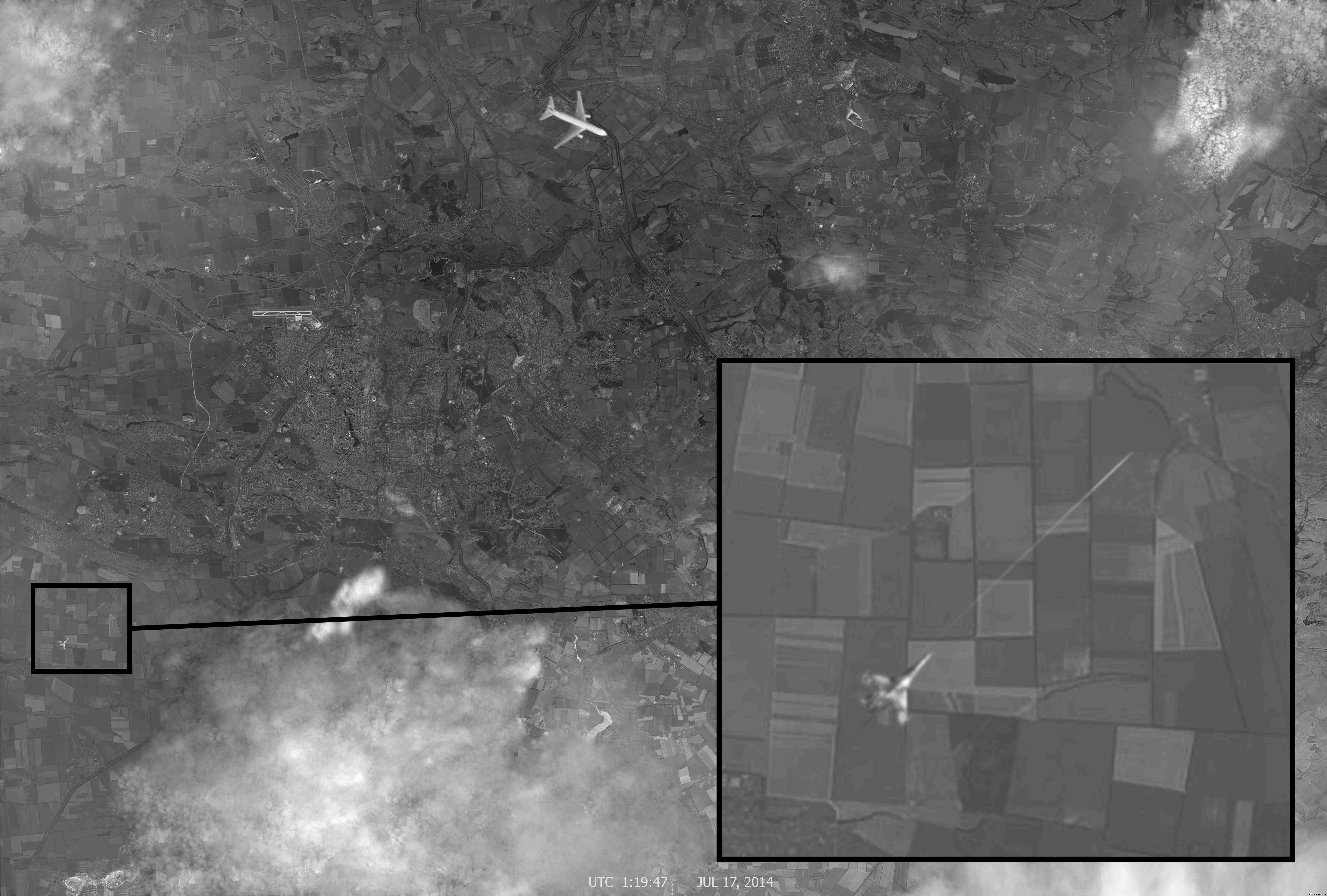
Back in July, Malaysia Airlines Flight 17 was shot down over Ukraine, killing all 298 people on board. We showed you some Digital Globe imagery of the crash site, which has since, in addition to other images, been added to Google Earth’s historical imagery.
It is generally believed that flight MH17 was shot down by pro-Russian separatists using a surface-to-air missile, but Russia has put the blame on the Ukrainian government. Official investigations into the crash have not yet made any findings as to who is responsible.
Last Friday, November 14th, 2014, Russian state television aired a story in which they showed satellite imagery purported to be of Flight MH17 being shot down by a fighter jet. However, it seems pretty clear that the image in question was a poorly done fake. For the full story and analysis of the imagery see the the article on bellingcat here.
We have created an image overlay of the photo for you to view in Google Earth which you can download here .
.

The picture that supposedly shows a fighter jet shooting down flight MH17. A high resolution version can be found here.
The post Fake photo of MH17 being shot down appeared first on Google Earth Blog.
Misplaced satellite image in Google Earth
by Timothy Whitehead on Nov.11, 2014, under 3D Models, Argentina, Australia, Brazil, California, Denmark, England, Germany, Google Earth News, Google Earth Tips, Google Sky, Google maps, Hawaii, Indonesia, Ireland, Italy, Japan, Kenya, Mexico, Natural Landmarks, Netherlands, Sightseeing, Street Views, USA
We have in the past talked about how the mapping data in Google Earth is not always completely accurate as well as how Google puts a lot of effort into improving and correcting the data.
In Google Earth, satellite imagery is not always perfectly aligned, which is to be expected, given the complexity of fitting an image that is typically taken at an oblique angle to the earth’s varied terrain. Despite that, in most cases the imagery is remarkably well aligned and can be used to correct mapping data from other sources that is often considerably less accurate. Google has continuously improved their systems to increase the accuracy of imagery placement.
We have recently come across what appears to be a satellite image that is entirely misplaced. GEB reader Horváth inquired about the satellite imagery not matching the street map in Kutaisi, Georgia. We had a look and it is clear that as of this writing, there is a misplaced satellite image for the region. There is correct imagery in ‘historical imagery’, but the default image in Google Earth and Google Maps is incorrect. To see the location for yourself in Google Earth download this KML file. We were unable to identify where the image is from.

Misplaced satellite image in Google Earth.

When zoomed out a little, a correct image can be seen.
The post Misplaced satellite image in Google Earth appeared first on Google Earth Blog.
The Koslanda landslide in Google Earth
by Timothy Whitehead on Nov.10, 2014, under 3D Models, Argentina, Australia, Brazil, California, Denmark, England, Germany, Google Earth News, Google Earth Tips, Google Sky, Google maps, Hawaii, Indonesia, Ireland, Italy, Japan, Kenya, Mexico, Natural Landmarks, Netherlands, Sightseeing, Street Views, USA
We have looked at a number of landslides in the past, including the Bingham Canyon mine landslide, a landslide near Oso, Washington and a whole set of landslides in Brazil.
On 29th October 2014, there was a landslide in the district of Badulla, Sri Lanka, which hit the village of Koslanda. A site called Groundviews has managed to obtain satellite imagery from Digital Globe showing the landslide and they also include a KML so that you can view it in Google Earth. Find the story and KML here.

The Koslanda landslide – imagery from Digital Globe
The post The Koslanda landslide in Google Earth appeared first on Google Earth Blog.
New Google Earth Imagery – November 3rd, 2014
by Timothy Whitehead on Nov.05, 2014, under 3D Models, Argentina, Australia, Brazil, California, Denmark, England, Germany, Google Earth News, Google Earth Tips, Google Sky, Google maps, Hawaii, Indonesia, Ireland, Italy, Japan, Kenya, Mexico, Natural Landmarks, Netherlands, Sightseeing, Street Views, USA
In our month end post we mentioned that GEB reader ‘munden’ had found updated imagery. Thanks also to GEB readers ‘Mapmaker’, Frank, Georg, and Sladys for letting us know about additional areas in the comments and via email. Now, Google have updated their ‘latest Google Earth Imagery’ map, showing the date 3rd November 2014. However, the aforementioned areas are not part of this current update, so it seems that once again Google have skipped telling us about an update.
I found out about the current update because I got an email from Google’s Follow Your World app that lets you monitor locations you are interested in and my home town of Livingstone, Zambia, was part of the update.

Latest Google Earth Imagery map – November 3rd, 2014. Larger version.
To view the map in Google Earth you can download this KML.
[Update: Thank you to GEB reader Maarten for letting us know that there was an update that we missed for October 21st, 2014 and for sending us a screen shot as seen below. ]

Google Earth Imagery map – October 21st, 2014. Larger version.
The post New Google Earth Imagery – November 3rd, 2014 appeared first on Google Earth Blog.
Earth View – Google Chrome extension
by Timothy Whitehead on Nov.04, 2014, under 3D Models, Argentina, Australia, Brazil, California, Denmark, England, Germany, Google Earth News, Google Earth Tips, Google Sky, Google maps, Hawaii, Indonesia, Ireland, Italy, Japan, Kenya, Mexico, Natural Landmarks, Netherlands, Sightseeing, Street Views, USA
Satellite imagery can be beautiful, and as a result, a number of people have used satellite imagery as art. For example, in 2010 we showed you the USGS “Earth as Art” collection, and earlier this year we talked about Roosmarijn Pallandt, who designs carpets using satellite imagery.
If you can’t get enough of satellite imagery, and you are a user of Google Chrome, there is a nice extension called Earth View (created by Google) that shows a different satellite image from Google Maps every time you open a new tab. I have been trying it out over the last couple of weeks, and although I missed some of the features of Chrome’s default ‘New Tab’ page, I am now used to it and really love the imagery. Find the Earth View extension in the Google Play store here.

Earth View shows you a different satellite image every time you open a new tab in Chrome.
I would like to see a number of additions to the extension, including:
- The option to use it as a background to the default ‘New Tab’ page rather than replacing it altogether.
- An ‘Open in Google Earth’ button in addition to the current links to Google Maps.
- A similar product that works as either a desktop background changer, or screen saver, or both.
- Occasional 3D scenery in addition to the top down satellite imagery.
If you have tried out the extension, what additions would you like to see?
The post Earth View – Google Chrome extension appeared first on Google Earth Blog.
Satellite font created from buildings
by Timothy Whitehead on Nov.03, 2014, under 3D Models, Argentina, Australia, Brazil, California, Denmark, England, Germany, Google Earth News, Google Earth Tips, Google Sky, Google maps, Hawaii, Indonesia, Ireland, Italy, Japan, Kenya, Mexico, Natural Landmarks, Netherlands, Sightseeing, Street Views, USA
In the past people have found faces hidden in satellite imagery, and the German design studio Onformative even went so far as to write a program to scan the whole globe using face recognition software. We have looked at unusually shaped buildings before, including a building shaped like a swastika. We have also pointed you to GoogleSightseeing.com’s collection of interestingly shaped pools.
A recent story in the news is about designer Yousuke Ozawa creating a font out of satellite images of buildings. See the full story here.

Satellite font by Yousuke Ozawa.
It turns out, however, that he is not the first to think of this. Back in 2008 we discovered via Google Maps Mania a clever site called geoGreeting that lets you send a message using letters made from buildings.

The intro-message on geoGreeting.
The post Satellite font created from buildings appeared first on Google Earth Blog.
Satellogic planning to achieve global coverage with live video and pictures
by Timothy Whitehead on Oct.28, 2014, under 3D Models, Argentina, Australia, Brazil, California, Denmark, England, Germany, Google Earth News, Google Earth Tips, Google Sky, Google maps, Hawaii, Indonesia, Ireland, Italy, Japan, Kenya, Mexico, Natural Landmarks, Netherlands, Sightseeing, Street Views, USA
Yesterday we talked about Skybox, which is owned by Google and currently has two satellites, but is planning a constellation of 24. When we talked about their gif animations of the Burning Man festival, we also pointed out a YouTube video that they say is the first HD resolution video of Earth from space. More videos from Skybox can also be found here
We recently came across this interesting article about a startup, Satellogic, that is planning to launch hundreds of satellites and provide live video and regular pictures with global coverage.
From their website:
We are building a constellation of satellites to image any spot on earth every few minutes.”
It won’t be as high resolution as the best images from Digital Globe, and we must remember that at any given time much of the globe is obscured by cloud cover, but global coverage with live video or pictures every few minutes is still exciting stuff!

BugSat-1 in a clean room.

The internals of a satellite.
The post Satellogic planning to achieve global coverage with live video and pictures appeared first on Google Earth Blog.
Skybox for Good
by Timothy Whitehead on Oct.27, 2014, under 3D Models, Argentina, Australia, Brazil, California, Denmark, England, Germany, Google Earth News, Google Earth Tips, Google Sky, Google maps, Hawaii, Indonesia, Ireland, Italy, Japan, Kenya, Mexico, Natural Landmarks, Netherlands, Sightseeing, Street Views, USA
Back in June 2014, Google acquired Skybox Imaging. In September, Skybox provided an impressive demonstration of their capabilities by capturing images of the Burning Man festival and producing animated gifs of its progress.
Now Skybox has announced the Skybox for Good program. Under the new program Skybox will work with non-profits to provide fresh satellite imagery where they need it. Of special interest is the fact that the images obtained via this program are being released under a Creative Commons By Attribution license (CC BY 4.0), which allows anyone to view and use the images.
Skybox has provided a map of images collected so far under the program that you can find here. You can also view it in Google Earth using this KML file.

Mining in the Appalachians – see the Skybox blog for details.
The post Skybox for Good appeared first on Google Earth Blog.