Tag: earth observatory
The tornado damage in Mayflower, Arkansas
by Mickey Mellen on May.06, 2014, under 3D Models, Argentina, Australia, Brazil, California, Denmark, England, Germany, Google Earth News, Google Earth Tips, Google Sky, Google maps, Hawaii, Indonesia, Ireland, Italy, Japan, Kenya, Mexico, Natural Landmarks, Netherlands, Sightseeing, Street Views, USA
The NASA Earth Observatory site brings us amazing images from time to time (such as some of these), and they’re back with some fresh imagery from the tornadoes that have ripped across the central United States in recent weeks.

The Mayflower tornado hit on April 27 and was rated an EF4. It left a path nearly 41 miles long and destroyed between 400-500 homes. From the Earth Observatory site:
At MODIS resolution, the entire town of Mayflower is barely distinguishable; but at ALI’s top resolution of 10 meters per pixel, it is possible to distinguish between individual buildings. In this ALI image, a trail of damaged trees and homes is visible near Interstate 40. The storm moved in a northeasterly direction, hitting the southern part of Mayflower first, then crossing I-40, and flattening neighborhoods along the shore of Lake Taylor.
You can read more on the NASA Earth Observatory site or download this KML file to view it for yourself in Google Earth.
The post The tornado damage in Mayflower, Arkansas appeared first on Google Earth Blog.
Pacific eruption turns two islands into one
by Mickey Mellen on Apr.04, 2014, under 3D Models, Argentina, Australia, Brazil, California, Denmark, England, Germany, Google Earth News, Google Earth Tips, Google Sky, Google maps, Hawaii, Indonesia, Ireland, Italy, Japan, Kenya, Mexico, Natural Landmarks, Netherlands, Sightseeing, Street Views, USA
Back in 1973, a volcanic eruption in the western Pacific ocean caused the formation of a new island named Nishino-shima. Four months ago, a nearby eruption caused the formation of a new island named Niijima. The Niijima eruption has continued and the island has been growing and has now consumed Nishino-shima and it is continuing to grow larger.

It’s quite a look at the birth of an island. From the NASA Earth Observatory site:
The Niijima portion of the island is now larger than the original Nishino-shima, and the merged island is slightly more than 1,000 meters across. Two cones have formed around the main vents and stand more than 60 meters above sea level, triple the highest point of the island in December. Volcanic lava flows are reported to be most active now on the south end of the island.
For more, check out the full article on the NASA Earth Observatory site or visit the Japan Coast Guard page to see aerial photographs of the island.
The post Pacific eruption turns two islands into one appeared first on Google Earth Blog.
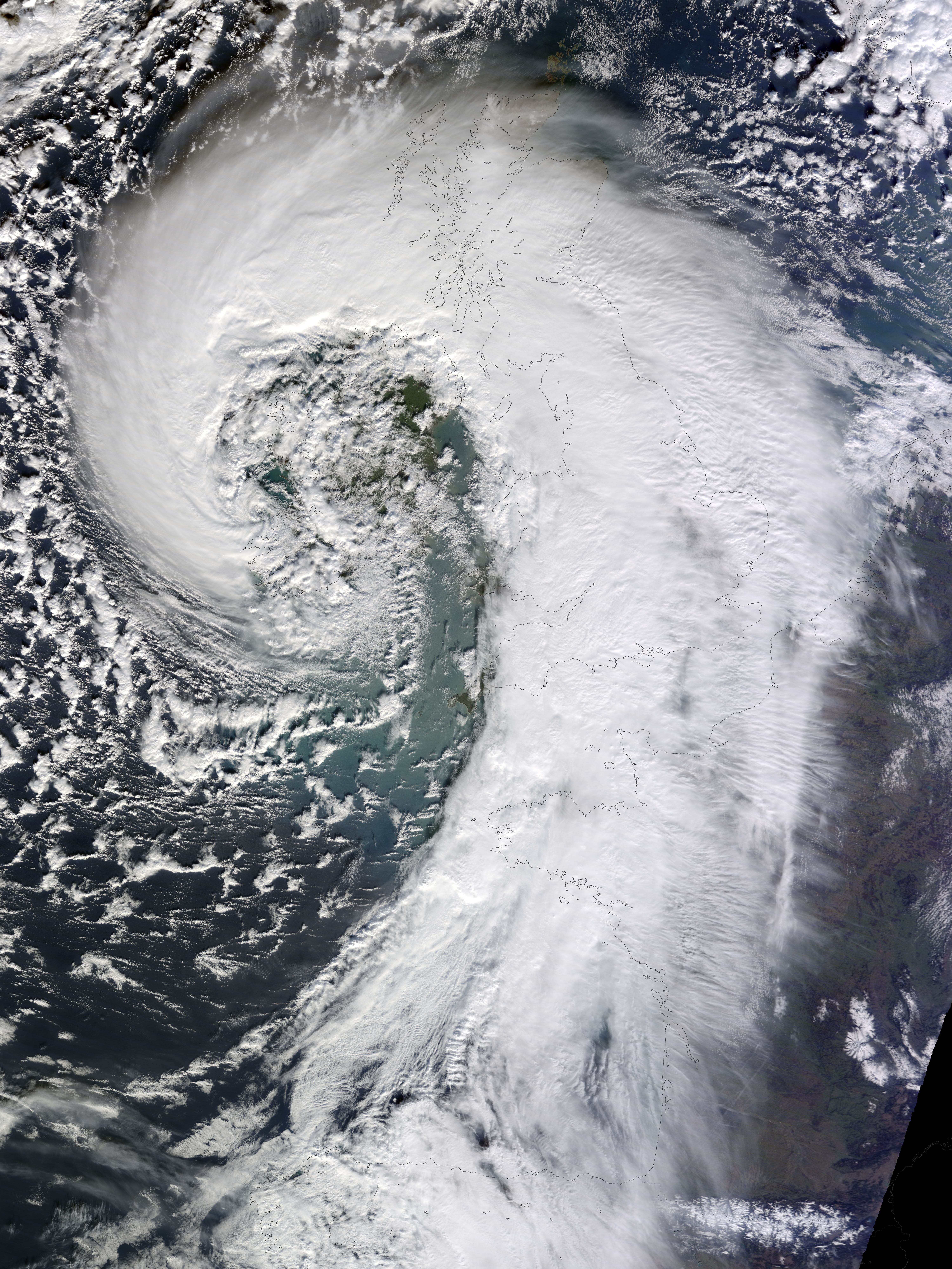
Amazing extratropical cyclone over the United Kingdom
by Mickey Mellen on Feb.18, 2014, under 3D Models, Argentina, Australia, Brazil, California, Denmark, England, Germany, Google Earth News, Google Earth Tips, Google Sky, Google maps, Hawaii, Indonesia, Ireland, Italy, Japan, Kenya, Mexico, Natural Landmarks, Netherlands, Sightseeing, Street Views, USA
The NASA Earth Observatory site is constantly releasing amazing images from space, including items such as this awesome image of Mount Everest, lava flow shapes, Laguna Verde, and many others. Their latest image is a stunning view of an extratropical cyclone over the United Kingdom that was captured last week.

This particular cyclone brought winds of over 100 miles per hour, and caused power outages to more than 700,000 people. They released a large image to show it off, which I’ve matched up in an image overlay and included in this KML file for you to view directly in Google Earth.
Read more about this cyclone on the Earth Observatory site or see other images from the Earth Observatory that we have showcased.
The post Amazing extratropical cyclone over the United Kingdom appeared first on Google Earth Blog.
Lava flow shapes in Google Earth
by Mickey Mellen on Dec.13, 2013, under 3D Models, Argentina, Australia, Brazil, California, Denmark, England, Germany, Google Earth News, Google Earth Tips, Google Sky, Google maps, Hawaii, Indonesia, Ireland, Italy, Japan, Kenya, Mexico, Natural Landmarks, Netherlands, Sightseeing, Street Views, USA
Because of the way Google Earth work, volcanoes are almost always amazing to view inside of it. 3D terrain combined with high-resolution imagery makes for some stunning views, as we explained a while back in our “A to Z” post about Volcanoes.
The NASA Earth Observatory recently posted an image and article about “lava flows”, seen here:

From their article:
Streams of molten rock that ooze from gaps or vents in the Earth’s surface are called lava flows, and they can pose a hazard to everything in their paths. These rivers of rock can take many shapes and move at very different rates depending on the viscosity of the magma, the slope of the land, and the rate of an eruption.
While viscous lava flows are defined by steep flow fronts and pressure ridges, low-viscosity lavas tend to move faster and create longer, narrower shapes. They also tend to have smaller flow fronts and levee-like structure along their edges. Many characteristics of a low-viscosity lava flow are visible in this image of Zhupanovsky and Dzenzursky volcanoes on Russia’s Kamchatka Peninsula. The image was acquired by the Operational Land Imager (OLI) on the Landsat 8 satellite on September 9, 2013.
To see this volcano for yourself, simply download this KML file and load it in Google Earth. For more, you can read the full story on the NASA Earth Observatory site.
The post Lava flow shapes in Google Earth appeared first on Google Earth Blog.
The ice of Mount Everest
by Mickey Mellen on Aug.12, 2013, under 3D Models, Argentina, Australia, Brazil, California, Denmark, England, Germany, Google Earth News, Google Earth Tips, Google Sky, Google maps, Hawaii, Indonesia, Ireland, Italy, Japan, Kenya, Mexico, Natural Landmarks, Netherlands, Sightseeing, Street Views, USA
We’ve looked at Mount Everest in Google Earth a number of times, including when Street View reached the mountain and the 60th anniversary of Sir Edmund Hillary’s historic ascent. The amazing size of the mountain coupled with Google Earth’s excellent views of natural formations makes it one of the best places to go sightseeing in Google Earth.

NASA’s Earth Observatory recently released some maps showing the outlines of glaciers around Everest, overlaid on top of a topographic map of the area. By matching it up and overlaying it on Google Earth, you’re given a very unique look at the mountain.

You can see it for yourself in Google Earth by using this KML file. For more, check out the full post on the NASA Earth Observatory site.
The post The ice of Mount Everest appeared first on Google Earth Blog.
The amazing colors of Laguna Verde, Argentina
by Mickey Mellen on May.30, 2013, under 3D Models, Argentina, Australia, Brazil, California, Denmark, England, Germany, Google Earth News, Google Earth Tips, Google Sky, Google maps, Hawaii, Indonesia, Ireland, Italy, Japan, Kenya, Mexico, Natural Landmarks, Netherlands, Sightseeing, Street Views, USA
The NASA Earth Observatory site shares many incredible images with us, and this image of Laguna Verde in northwest Argentina is amazing!

The various colors of the water are due to a variety of microscopic organisms that live in the lake. According to NASA:
Laguna Verde (58 kilometers wide, 36 km long) often appears green, giving rise to its name. This image shows the turquoise tint in the central sub-basin (image center), with a yellow to black tinge to water in the southern sub-basin (left)—also known locally as Laguna Negro. The northernmost basin (right) appears black. The large gray zone comprising much of the rest of Laguna Verde is likely a combination of shallow water—only inches deep—and sunglint reflecting off the water surface. The reason for the color differences is that many different families of salt-loving organisms occupy hypersaline lakes such as Laguna Verde. These microscopic organisms appear as different colors, often bright, depending on the salinity and temperature of each water body or sub-basin.
You can view it for yourself by loading this KML file in Google Earth, or visit this page on the NASA Earth Observatory site to learn more.
The post The amazing colors of Laguna Verde, Argentina appeared first on Google Earth Blog.