Tag: google Crisis response
More post-Hurricane Matthews imagery
by Timothy Whitehead on Oct.12, 2016, under 3D Models, Argentina, Australia, Brazil, California, Denmark, England, Germany, Google Earth News, Google Earth Tips, Google Sky, Google maps, Hawaii, Indonesia, Ireland, Italy, Japan, Kenya, Mexico, Natural Landmarks, Netherlands, Sightseeing, Street Views, USA
[ Update: See this post for a KML to view to see the NOAA imagery in Google Earth. ]
On Monday we had a look at some imagery via Google Crisis Response of the devastation caused by Hurricane Matthews.
Google has since added quite a lot of new imagery to the KML file that we linked to on Monday. The KML file uses a network link, so if you still have it you should automatically see any new imagery that is added.
In addition, Google has made available on this map a large amount of aerial imagery provided by NOAA. To access it, go to the layers and select ‘Aerial Photos’. Then zoom to the eastern coast of the US and you will see a thin strip of aerial imagery all along the coast.

The NOAA imagery can also be viewed on this NOAA map, which also offers the option to download the imagery. Unfortunately, the imagery is not currently in a format easily viewed in Google Earth and Google does not currently have plans to add it to the above KML file.


Before and After of Flagler Beach, Florida showing damage to the coastal road.


Before and After of a new inlet formed along the Florida coast. To find it on the map search for ‘Rattlesnake Island’.

Some flooded roads in Charleston, South Carolina.

As a bonus, we get a look at Space Launch Complex 40 where SpaceX AMOS-6 mission spectacularly blew up in September.
See this article for a number of aerial and ground level photos of the damage caused by Hurricane Matthews.
The post More post-Hurricane Matthews imagery appeared first on Google Earth Blog.
Hurricane Matthew imagery via Google Crisis Response
by Timothy Whitehead on Oct.10, 2016, under 3D Models, Argentina, Australia, Brazil, California, Denmark, England, Germany, Google Earth News, Google Earth Tips, Google Sky, Google maps, Hawaii, Indonesia, Ireland, Italy, Japan, Kenya, Mexico, Natural Landmarks, Netherlands, Sightseeing, Street Views, USA
Hurricane Matthew is an extra-tropical cyclone that impacted Haiti, Jamaica, Cuba, Dominican Republic and The Bahamas and as of this writing is moving along the coast of the southeastern United States causing heavy rains and consequent flooding.
The NOAA’s National Hurricane Centre provides this KML file showing the path of Hurricane Matthew.

The path of Hurricane Matthew as of October 9th, 2016.
Google Crisis response has released two maps. There is this Florida emergency preparedness map, which actually contains a variety of related information for the whole east coast of the US. Then there is this ‘Haiti Hurricane’ map, which has imagery from DigitalGlobe and Google’s Terra Bella of various parts of Haiti.
Google Crisis Response also kindly provided this KML file , which includes imagery of Haiti and the Bahamas. It is a network link so it will update as they add new imagery. As of this writing it does not include the Terra Bella imagery but they have stated that they will be adding that shortly.
As is normal for imagery gathered after natural disasters, the imagery is not the best quality but we can see that many houses have lost their roofs or worse.
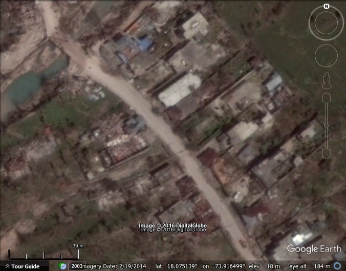
Port Salut, Haiti.

Port Salut, Haiti.


Before and after of Tiburon, Haiti.
The post Hurricane Matthew imagery via Google Crisis Response appeared first on Google Earth Blog.
First satellite imagery of flooding in southern India
by Timothy Whitehead on Dec.10, 2015, under 3D Models, Argentina, Australia, Brazil, California, Denmark, England, Germany, Google Earth News, Google Earth Tips, Google Sky, Google maps, Hawaii, Indonesia, Ireland, Italy, Japan, Kenya, Mexico, Natural Landmarks, Netherlands, Sightseeing, Street Views, USA
South eastern India has recently experienced major flooding. The floods have been caused by a combination of unusually high rainfall and a number of human factors, including unplanned urban development on former wetlands and other natural sinks and possibly poor reservoir management.
As they usually do for major disasters, Google has set up this Google Crisis Response page and also released some imagery from DigitalGlobe, which you can view on this map.

The imagery is black & white and rather cloudy, but the extent of the flooding can clearly be seen.
There doesn’t seem to be a way to view the images in Google Earth, so we hope they release a KML file as they have on previous occasions.
For more on the flooding and some photos see this article
Google has recently done an imagery update in Google Earth, but there is no recent imagery for the area affected by the floods. The update includes imagery up to November 30th, 2015.
The post First satellite imagery of flooding in southern India appeared first on Google Earth Blog.
Google Crisis Response
by Timothy Whitehead on Oct.09, 2015, under 3D Models, Argentina, Australia, Brazil, California, Denmark, England, Germany, Google Earth News, Google Earth Tips, Google Sky, Google maps, Hawaii, Indonesia, Ireland, Italy, Japan, Kenya, Mexico, Natural Landmarks, Netherlands, Sightseeing, Street Views, USA
Google Crisis Response provides a variety of tools to assist with crisis response efforts around the globe. One of the tools it provides is maps, which often include satellite imagery of relevant areas well before the imagery is available in Google Earth, and sometimes includes imagery that never makes it into Google Earth.
Unlike DigitalGlobe’s FirstLook program, which provides satellite imagery exclusively to crisis response organizations, the Google Crisis response maps are open to the public.
There is typically a map for each disaster area and the maps often include links to KMLs so that the data can be viewed in Google Earth. Navigating between the maps is not particularly obvious. To start, go to this URL. By default it shows the ‘Weather, Hazards, Emergency Preparedness’ map, which at present is highlighting a recent flooding in South Carolina and includes two satellite images from DigitalGlobe. Sadly, there appears to be no way to see those images in Google Earth. Sometimes the imagery is available in KML format. When we recently looked at the wild fires in California, GEB reader Christiaan Adams let us know in the comments about this KML file that is from Google Crisis Response and does show DigitialGlobe imagery in Google Earth. Yesterday when we looked at the Tianjin explosion we pointed you to this KML file from Google Crysis Response that shows Skybox Imagery of Tianjin before and after the event in Google Earth.
Once you are on the ‘Weather, Hazards, Emergency Preparedness’ map, you can find other maps by clicking on the map title and a drop down appears, showing a list of other maps. At the current point in time there are:
- Weather, Hazards, Emergency Preparedness
- 2014 US Winter Storm (Pax)
- 2015 Nepal Earthquake
- Australia Fires
- Banjir Indonesia 2014
- Incendio en Valparaíso (the Great Fire of Valparaíso, Chile)
- NSW Bushfires (New South Wales, Australia)
- Philippines Crisis Map
- State of Florida Emergency Preparedness
- 臺灣防災地圖 (Taiwan Crisis Map)
Other maps do exist but are not on the drop-down list. For example, we found these:
- Myanmar Flooding
- 災害情報マップ (Earthquake, weather and tsunami map of Japan)
We found those maps via the Google Crisis Response Google+ page.
Once you are viewing a map, be sure to click the ‘Layers’ button for extra information and quite often the option to download the data in Google Earth. For example, the ‘Weather, Hazards, Emergency Preparedness’ in the ‘Storm Information’ layer there is this KML file showing web cams all along the gulf coast and various locations in the Caribbean.

The post Google Crisis Response appeared first on Google Earth Blog.