Archive for October, 2012
We have a floater
by tmblwd53 on Oct.10, 2012, under 3D Models, Argentina, Australia, Brazil, California, Denmark, England, Germany, Google Earth News, Google Earth Tips, Google Sky, Google maps, Hawaii, Indonesia, Ireland, Italy, Japan, Kenya, Mexico, Natural Landmarks, Netherlands, Sightseeing, Street Views, USA
Comments Off :Animals, Canada, funny street view, Sleeping more...Happy Hour in Thailand with Tuxedo Kitty
by tmblwd53 on Oct.09, 2012, under 3D Models, Argentina, Australia, Brazil, California, Denmark, England, Germany, Google Earth News, Google Earth Tips, Google Sky, Google maps, Hawaii, Indonesia, Ireland, Italy, Japan, Kenya, Mexico, Natural Landmarks, Netherlands, Sightseeing, Street Views, USA
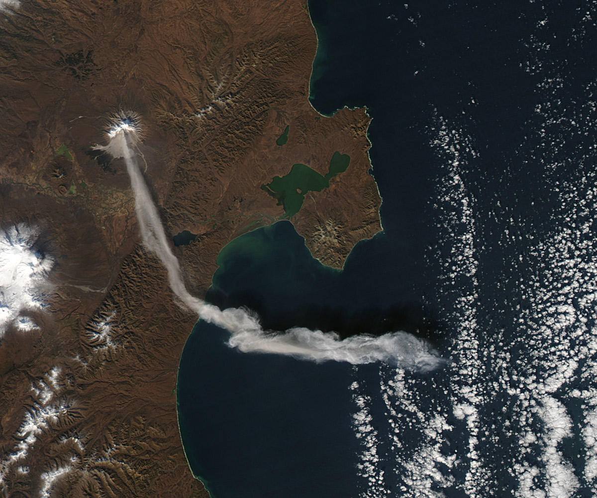
Comments Off :Animals, funny street view, Thailand more...Viewing the ash plume from the Shiveluch Volcano
by Google Earth Blog on Oct.09, 2012, under 3D Models, Argentina, Australia, Brazil, California, Denmark, England, Germany, Google Earth News, Google Earth Tips, Google Sky, Google maps, Hawaii, Indonesia, Ireland, Italy, Japan, Kenya, Mexico, Natural Landmarks, Netherlands, Sightseeing, Street Views, USA
Just a few days ago we talked about some of the great volcanoes that can be seen in Google Earth. Almost on cue, the NASA Earth Observatory has released some amazing imagery of the Shiveluch Volcano in Russia.

The image was captured just three days ago, and clearly shows the ash plume which had already traveled roughly 140 miles from the summit of the volcano.
From their page:
Shiveluch (also spelled Sheveluch) ranks among the biggest and most active volcanoes on the Kamchatka Peninsula. Rising to 3,283 meters (10,771 feet) above sea level, Shiveluch is a stratovolcano composed of alternating layers of hardened lava, compacted ash, and rocks ejected by previous eruptions. The beige-colored expanse of rock on the volcano's southern slopes (visible in both images) is due to an explosive eruption that occurred in 1964. Part of Shiveluch's southern flank collapsed, and the light-colored rock is avalanche debris left by that event.
NASA has released a high resolution jpg of the imagery, and also a KMZ file so that you can view it in Google Earth.
(via EarthObservatory)
Don’t touch my limo
by fisgonmorboson on Oct.09, 2012, under 3D Models, Argentina, Australia, Brazil, California, Denmark, England, Germany, Google Earth News, Google Earth Tips, Google Sky, Google maps, Hawaii, Indonesia, Ireland, Italy, Japan, Kenya, Mexico, Natural Landmarks, Netherlands, Sightseeing, Street Views, USA
Comments Off :beverly hills, Cars, funny street view more...Natural wonder of Croatia
by fisgonmorboson on Oct.09, 2012, under 3D Models, Argentina, Australia, Brazil, California, Denmark, England, Germany, Google Earth News, Google Earth Tips, Google Sky, Google maps, Hawaii, Indonesia, Ireland, Italy, Japan, Kenya, Mexico, Natural Landmarks, Netherlands, Sightseeing, Street Views, USA
Comments Off :Croatia, funny street view, girl more...Seeview in Porec
by takkeherrie on Oct.09, 2012, under 3D Models, Argentina, Australia, Brazil, California, Denmark, England, Germany, Google Earth News, Google Earth Tips, Google Sky, Google maps, Hawaii, Indonesia, Ireland, Italy, Japan, Kenya, Mexico, Natural Landmarks, Netherlands, Sightseeing, Street Views, USA
Comments Off :Croatia, funny street view more...The Hampton Roads Bridge-Tunnel
by Google Earth Blog on Oct.08, 2012, under 3D Models, Argentina, Australia, Brazil, California, Denmark, England, Germany, Google Earth News, Google Earth Tips, Google Sky, Google maps, Hawaii, Indonesia, Ireland, Italy, Japan, Kenya, Mexico, Natural Landmarks, Netherlands, Sightseeing, Street Views, USA
Opened nearly 55 years ago, the 3.5 mile long Hampton Roads (Virginia) Bridge-Tunnel is an amazing four-lane bridge/tunnel that goes across and under the main shipping channels for Hampton Roads harbor. As you would expect, it looks pretty awesome in Google Earth.

It'd be cool to see more of it in 3D, especially the underwater tunnel, but it's quite impressive with just the satellite imagery to view. As most bridges do, it replaced a ferry route that had been active prior to its construction. When it opened in 1958, it had an average of 6,000 vehicles that used it each day. The average is now 66,000/day, with spikes over 100,000 during tourist seasons.
You can read more about the Bridge-Tunnel on their Wikipedia page, or see it for yourself in Google Earth with this KML file.
Half Google man and a beautiful girl
by fisgonmorboson on Oct.08, 2012, under 3D Models, Argentina, Australia, Brazil, California, Denmark, England, Germany, Google Earth News, Google Earth Tips, Google Sky, Google maps, Hawaii, Indonesia, Ireland, Italy, Japan, Kenya, Mexico, Natural Landmarks, Netherlands, Sightseeing, Street Views, USA
Comments Off :Cam errors, Croatia, funny street view, Google car and crew more...J walking
by jjw23 on Oct.08, 2012, under 3D Models, Argentina, Australia, Brazil, California, Denmark, England, Germany, Google Earth News, Google Earth Tips, Google Sky, Google maps, Hawaii, Indonesia, Ireland, Italy, Japan, Kenya, Mexico, Natural Landmarks, Netherlands, Sightseeing, Street Views, USA
Comments Off :funny street view more...Ukainian girl posing for google
by fisgonmorboson on Oct.08, 2012, under 3D Models, Argentina, Australia, Brazil, California, Denmark, England, Germany, Google Earth News, Google Earth Tips, Google Sky, Google maps, Hawaii, Indonesia, Ireland, Italy, Japan, Kenya, Mexico, Natural Landmarks, Netherlands, Sightseeing, Street Views, USA
Comments Off :funny street view, girl, Ukraine more...