Archive for December, 2012
Airplane
by lmqp on Dec.20, 2012, under 3D Models, Argentina, Australia, Brazil, California, Denmark, England, Germany, Google Earth News, Google Earth Tips, Google Sky, Google maps, Hawaii, Indonesia, Ireland, Italy, Japan, Kenya, Mexico, Natural Landmarks, Netherlands, Sightseeing, Street Views, USA
Comments Off :Airplane, funny street view, New Zealand more...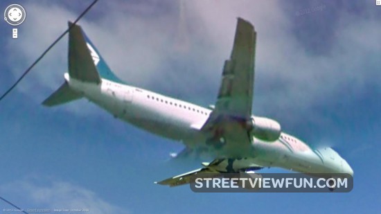
Can you guess what happened next?
by StreetViewFun.com on Dec.20, 2012, under 3D Models, Argentina, Australia, Brazil, California, Denmark, England, Germany, Google Earth News, Google Earth Tips, Google Sky, Google maps, Hawaii, Indonesia, Ireland, Italy, Japan, Kenya, Mexico, Natural Landmarks, Netherlands, Sightseeing, Street Views, USA
Comments Off :funny street view more...

Google Car View!
by Matt81 on Dec.19, 2012, under 3D Models, Argentina, Australia, Brazil, California, Denmark, England, Germany, Google Earth News, Google Earth Tips, Google Sky, Google maps, Hawaii, Indonesia, Ireland, Italy, Japan, Kenya, Mexico, Natural Landmarks, Netherlands, Sightseeing, Street Views, USA
This image has been taken inside a Nissan car at a Nissan dealer (Nissan of South Holland) in Chicago.

Predicting volcanic ash with Google Earth
by Google Earth Blog on Dec.19, 2012, under 3D Models, Argentina, Australia, Brazil, California, Denmark, England, Germany, Google Earth News, Google Earth Tips, Google Sky, Google maps, Hawaii, Indonesia, Ireland, Italy, Japan, Kenya, Mexico, Natural Landmarks, Netherlands, Sightseeing, Street Views, USA
The "Puff-Volcanic Ash Tracking Model" is a system of Google Maps and Google Earth KML files that help predict the ash patterns for volcanoes around the world. As explained in their user manual:
Puff simulates the transport, dispersion and sedimentation of volcanic ash. It requires horizontal wind field data as a function of height on a regular grid covering the area of interest. Puff output includes the location (in 3 dimensions), size, and age-since-eruption of representative ash particles. It can also produce gridded data of relative and absolute ash concentration in the air and on the ground. Puff is a fast and efficient research and operational tool for predicting the trajectories of ash particles, which is essential for hazard assessment.
When you visit their site, you can click on any volcano icon to view information about their predicted ash trajectory, as seen here:

In many cases, you can click on the "3D" icon to view the ash cloud as a 3D tour in Google Earth, as seen here:

It's quite a sophisticated system, and could be quite useful in the event of a major eruption. You can see it all for yourself on the Puff website.
Looking good in Croatia
by lmqp on Dec.19, 2012, under 3D Models, Argentina, Australia, Brazil, California, Denmark, England, Germany, Google Earth News, Google Earth Tips, Google Sky, Google maps, Hawaii, Indonesia, Ireland, Italy, Japan, Kenya, Mexico, Natural Landmarks, Netherlands, Sightseeing, Street Views, USA
Comments Off :Croatia, funny street view more...Interactive map of the U.S. Nuclear Weapons Complex
by Google Earth Blog on Dec.18, 2012, under 3D Models, Argentina, Australia, Brazil, California, Denmark, England, Germany, Google Earth News, Google Earth Tips, Google Sky, Google maps, Hawaii, Indonesia, Ireland, Italy, Japan, Kenya, Mexico, Natural Landmarks, Netherlands, Sightseeing, Street Views, USA
Last week the staff at the Union of Concerned Scientists released an impressive interactive KML that shows facilities around the United states that are involved in the production and maintenance of nuclear weapons.
The map shows off dozens of sites across the country, including the lab in Los Alamos seen below:

When you zoom in closer, the information becomes more detailed:

There is an amazing amount of information in this file, all of which was pulled from public sources. You can view it for yourself by downloading this KML file, or you can read more about it on this page on the UCS website.
Three legs in the sky
by lmqp on Dec.18, 2012, under 3D Models, Argentina, Australia, Brazil, California, Denmark, England, Germany, Google Earth News, Google Earth Tips, Google Sky, Google maps, Hawaii, Indonesia, Ireland, Italy, Japan, Kenya, Mexico, Natural Landmarks, Netherlands, Sightseeing, Street Views, USA
Comments Off :Cam errors, funny street view more...
Tanning the thighs
by nummie on Dec.18, 2012, under 3D Models, Argentina, Australia, Brazil, California, Denmark, England, Germany, Google Earth News, Google Earth Tips, Google Sky, Google maps, Hawaii, Indonesia, Ireland, Italy, Japan, Kenya, Mexico, Natural Landmarks, Netherlands, Sightseeing, Street Views, USA
Comments Off :beach, funny street view, Weird people more...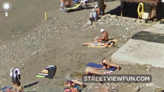
Google crew takes a picture at Monza track
by lmqp on Dec.18, 2012, under 3D Models, Argentina, Australia, Brazil, California, Denmark, England, Germany, Google Earth News, Google Earth Tips, Google Sky, Google maps, Hawaii, Indonesia, Ireland, Italy, Japan, Kenya, Mexico, Natural Landmarks, Netherlands, Sightseeing, Street Views, USA
Comments Off :Cars, funny street view, Google car and crew, Photography more...
New Google Imagery – December 17
by Google Earth Blog on Dec.17, 2012, under 3D Models, Argentina, Australia, Brazil, California, Denmark, England, Germany, Google Earth News, Google Earth Tips, Google Sky, Google maps, Hawaii, Indonesia, Ireland, Italy, Japan, Kenya, Mexico, Natural Landmarks, Netherlands, Sightseeing, Street Views, USA
Thanks to a post from Dave Spracklen in the Google Earth G+ Community, we've learned that Google has just updated imagery in a variety of locations around the world.

As they've done a few times, this imagery appeared first in Google Maps, and as of now still hasn't arrived in Google Earth. You can compare the two programs side-by-side to see if a specific area is new.
Depending on the city that you check, you'll need to be aware of a few things. Tucson, Arizona is a great example; in Google Earth you need to turn off the "3d imagery" (under Tools --> Options) to see the base imagery, and in Google Maps you can't zoom in too far or else you'll hit the 45 degree imagery (which was captured at a different time).
- China: Qingdao, Xujia
- Croatia: Rijeka
- Greece: western part of Athens, Perama
- South Korea: Chinhae and a lot of the port area
- United States: Arizona (Tucson), Washington, DC
If you find any other updated areas, please leave a comment and let us know!