Archive for January, 2013
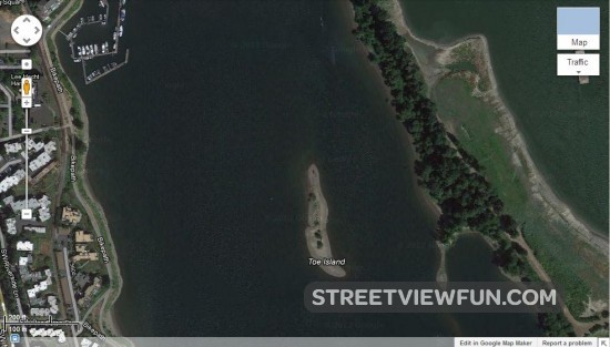
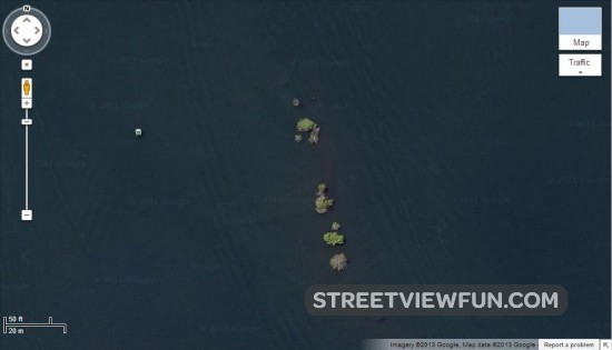
Watch Toe Island disappear before your eyes on Google Maps satellite images
by StreetViewFun.com on Jan.30, 2013, under 3D Models, Argentina, Australia, Brazil, California, Denmark, England, Germany, Google Earth News, Google Earth Tips, Google Sky, Google maps, Hawaii, Indonesia, Ireland, Italy, Japan, Kenya, Mexico, Natural Landmarks, Netherlands, Sightseeing, Street Views, USA
Toe Island is located in the Willamette river in Portland, Oregon. This tiny island is described as a navigational hazard and it’s easy to see why when you zoom in on Google Maps.
Local copies of the satellite images can be seen here too:
Just in time
by StreetViewFun.com on Jan.30, 2013, under 3D Models, Argentina, Australia, Brazil, California, Denmark, England, Germany, Google Earth News, Google Earth Tips, Google Sky, Google maps, Hawaii, Indonesia, Ireland, Italy, Japan, Kenya, Mexico, Natural Landmarks, Netherlands, Sightseeing, Street Views, USA
Comments Off :Czech Republic, funny street view more...
Giant bird emerging from chimney
by StreetViewFun.com on Jan.29, 2013, under 3D Models, Argentina, Australia, Brazil, California, Denmark, England, Germany, Google Earth News, Google Earth Tips, Google Sky, Google maps, Hawaii, Indonesia, Ireland, Italy, Japan, Kenya, Mexico, Natural Landmarks, Netherlands, Sightseeing, Street Views, USA
Comments Off :Animals, funny street view, UK more...
The Umbrellas of Cherbourg
by StreetViewFun.com on Jan.29, 2013, under 3D Models, Argentina, Australia, Brazil, California, Denmark, England, Germany, Google Earth News, Google Earth Tips, Google Sky, Google maps, Hawaii, Indonesia, Ireland, Italy, Japan, Kenya, Mexico, Natural Landmarks, Netherlands, Sightseeing, Street Views, USA
Comments Off :Art, France, funny street view more...
Anomalies in Google Earth and why they exist
by Google Earth Blog on Jan.29, 2013, under 3D Models, Argentina, Australia, Brazil, California, Denmark, England, Germany, Google Earth News, Google Earth Tips, Google Sky, Google maps, Hawaii, Indonesia, Ireland, Italy, Japan, Kenya, Mexico, Natural Landmarks, Netherlands, Sightseeing, Street Views, USA
While the content in Google Earth is remarkably polished, there are still map glitches to be found from time to time. For example, here are a few hundred of them that people have posted over on Google Earth Hacks.

Clement Valla at Rhizome has taken a closer look at how these anomalies occur and has arrived an an interesting conclusion:
At first, I thought they were glitches, or errors in the algorithm, but looking closer, I realized the situation was actually more interesting -- these images are not glitches. They are the absolute logical result of the system. They are an edge condition--an anomaly within the system, a nonstandard, an outlier, even, but not an error. These jarring moments expose how Google Earth works, focusing our attention on the software. They are seams which reveal a new model of seeing and of representing our world - as dynamic, ever-changing data from a myriad of different sources - endlessly combined, constantly updated, creating a seamless illusion.
It's an impressive dive into the system of how Google selects imagery to be used in Google Earth. Valla discusses the basic idea that "better photographs are flatter, have fewer shadows and are taken from higher angles" and that broken images like that ones that he showcases are becoming more and more difficult to find. It's also worth reading this post about how Google captures and loads imagery into Google Earth.
Clement's piece is quite informative, and you can read the full article at Rhizome.
Where to park it for colon hydrotherapy…
by StreetViewFun.com on Jan.29, 2013, under 3D Models, Argentina, Australia, Brazil, California, Denmark, England, Germany, Google Earth News, Google Earth Tips, Google Sky, Google maps, Hawaii, Indonesia, Ireland, Italy, Japan, Kenya, Mexico, Natural Landmarks, Netherlands, Sightseeing, Street Views, USA
Comments Off :funny street view, Signs more...
A cheeky situation…
by StreetViewFun.com on Jan.29, 2013, under 3D Models, Argentina, Australia, Brazil, California, Denmark, England, Germany, Google Earth News, Google Earth Tips, Google Sky, Google maps, Hawaii, Indonesia, Ireland, Italy, Japan, Kenya, Mexico, Natural Landmarks, Netherlands, Sightseeing, Street Views, USA
Comments Off :Canada, funny street view more...

More photos from inside Russian & Turkish Baths
by johndoe on Jan.29, 2013, under 3D Models, Argentina, Australia, Brazil, California, Denmark, England, Germany, Google Earth News, Google Earth Tips, Google Sky, Google maps, Hawaii, Indonesia, Ireland, Italy, Japan, Kenya, Mexico, Natural Landmarks, Netherlands, Sightseeing, Street Views, USA
Comments Off :funny street view more...


Google entering a soccer stadium in Brazil
by StreetViewFun.com on Jan.28, 2013, under 3D Models, Argentina, Australia, Brazil, California, Denmark, England, Germany, Google Earth News, Google Earth Tips, Google Sky, Google maps, Hawaii, Indonesia, Ireland, Italy, Japan, Kenya, Mexico, Natural Landmarks, Netherlands, Sightseeing, Street Views, USA
Comments Off :funny street view, Sports more...
Using Google Earth for 3D Property Listings
by Google Earth Blog on Jan.28, 2013, under 3D Models, Argentina, Australia, Brazil, California, Denmark, England, Germany, Google Earth News, Google Earth Tips, Google Sky, Google maps, Hawaii, Indonesia, Ireland, Italy, Japan, Kenya, Mexico, Natural Landmarks, Netherlands, Sightseeing, Street Views, USA
While Google Maps is a very popular and suitable tool for most kinds of real estate listings, the 3D features in Google Earth can be very useful to visualize real estate inside of tall buildings. Cube Cities does an amazing job of that, by clearly highlighting the location of their properties with obvious markings on the face of the 3D building itself. It's quite effective.

Clicking on red area then provides you with details about that listing, as seen here.

It uses the Google Earth API to display the buildings, then overlays them with various colored polygons to indicate the available space. It's an excellent use of Google Earth and has been put together very well.
Check it out for yourself at CubeCities.com.
(via Google Maps Mania)