Archive for October, 2016
Getting tiled maps into Google Earth
by Timothy Whitehead on Oct.13, 2016, under 3D Models, Argentina, Australia, Brazil, California, Denmark, England, Germany, Google Earth News, Google Earth Tips, Google Sky, Google maps, Hawaii, Indonesia, Ireland, Italy, Japan, Kenya, Mexico, Natural Landmarks, Netherlands, Sightseeing, Street Views, USA
[ Update: See this post for a KML to view to see the NOAA imagery in Google Earth. ]
Yesterday we had a look at some aerial imagery of the eastern coast of the US after Hurricane Matthew. The imagery comes from NOAA. We wondered what it would take to get the imagery into Google Earth. The NOAA has made the imagery available for viewing on this map and also offers the option to download it. However, the total size of all the imagery is over 24 GB. Also provided is the option to view the imagery as tiled data.
Most modern online maps use a fairly standardised method of tiling the map imagery. It is a relatively simple system that involves using the Mercator map projection and cutting off above 85.0511°N and below 85.0511°S, resulting in a map of the globe that is square. This is then divided into four squares, each of which is divided into four squares and so on. Each division is a zoom level. For the full technical details see this page.
Google Earth has a mechanism for presenting tiled data that is very similar to the above process. You can take a large image overlay and break it up into tiles in such a way that Google Earth only loads the tiles that are within the view and at a suitable resolution. The result is called a ‘Super-Overlay’. Google Earth Pro even has a built-in tool for creating these automatically which you can read more about here.
We already had some basic JavaScript code for working with map tiles that we created to work with Mapzen altitude data, which is available as map tiles. We combined this with information from the KML Developers Guide and technical information about the NOAA tiles and were able to create a Super-Overlay for a small portion of the NOAA data. And it works quite well. The problem is that it doesn’t scale.
You can download our sample here . It covers a short stretch of coast near Charleston, North Carolina. A Google Earth Super-Overlay actually consists of many KML files all network-linked to each other in a hierarchical fashion. Our sample file is actually in the compressed KMZ format and includes over 10,000 files which uncompressed are over 10 Mb. Keep in mind that the KML file does not contain any imagery at all, that is all coming directly from NOAA. When we tried to create larger Super-Overlays it crashed our JavaScript as the browser ran out of memory. We could probably find ways to generate larger Super-Overlays, but there is no getting around the file size, so it is practically impossible to do a single KML file for all the NOAA imagery.
The only real alternative would be to set up a server with all the Super-Overlay files. This would probably work quite well, but running a server in this particular instance is not worth it. What would be ideal would be for Google Earth to natively support map tiles such that you could give it the details of the tile server and it would handle it from there.

NOAA imagery as seen in Google Earth. Some flooding near Charleston, North Carolina.
The post Getting tiled maps into Google Earth appeared first on Google Earth Blog.
Car crash in Serbia
by wp.dejan on Oct.13, 2016, under 3D Models, Argentina, Australia, Brazil, California, Denmark, England, Germany, Google Earth News, Google Earth Tips, Google Sky, Google maps, Hawaii, Indonesia, Ireland, Italy, Japan, Kenya, Mexico, Natural Landmarks, Netherlands, Sightseeing, Street Views, USA
More post-Hurricane Matthews imagery
by Timothy Whitehead on Oct.12, 2016, under 3D Models, Argentina, Australia, Brazil, California, Denmark, England, Germany, Google Earth News, Google Earth Tips, Google Sky, Google maps, Hawaii, Indonesia, Ireland, Italy, Japan, Kenya, Mexico, Natural Landmarks, Netherlands, Sightseeing, Street Views, USA
[ Update: See this post for a KML to view to see the NOAA imagery in Google Earth. ]
On Monday we had a look at some imagery via Google Crisis Response of the devastation caused by Hurricane Matthews.
Google has since added quite a lot of new imagery to the KML file that we linked to on Monday. The KML file uses a network link, so if you still have it you should automatically see any new imagery that is added.
In addition, Google has made available on this map a large amount of aerial imagery provided by NOAA. To access it, go to the layers and select ‘Aerial Photos’. Then zoom to the eastern coast of the US and you will see a thin strip of aerial imagery all along the coast.

The NOAA imagery can also be viewed on this NOAA map, which also offers the option to download the imagery. Unfortunately, the imagery is not currently in a format easily viewed in Google Earth and Google does not currently have plans to add it to the above KML file.


Before and After of Flagler Beach, Florida showing damage to the coastal road.


Before and After of a new inlet formed along the Florida coast. To find it on the map search for ‘Rattlesnake Island’.

Some flooded roads in Charleston, South Carolina.

As a bonus, we get a look at Space Launch Complex 40 where SpaceX AMOS-6 mission spectacularly blew up in September.
See this article for a number of aerial and ground level photos of the damage caused by Hurricane Matthews.
The post More post-Hurricane Matthews imagery appeared first on Google Earth Blog.
Hot Lava
by jupjup on Oct.11, 2016, under 3D Models, Argentina, Australia, Brazil, California, Denmark, England, Germany, Google Earth News, Google Earth Tips, Google Sky, Google maps, Hawaii, Indonesia, Ireland, Italy, Japan, Kenya, Mexico, Natural Landmarks, Netherlands, Sightseeing, Street Views, USA
Panoramio shutdown date set
by Timothy Whitehead on Oct.11, 2016, under 3D Models, Argentina, Australia, Brazil, California, Denmark, England, Germany, Google Earth News, Google Earth Tips, Google Sky, Google maps, Hawaii, Indonesia, Ireland, Italy, Japan, Kenya, Mexico, Natural Landmarks, Netherlands, Sightseeing, Street Views, USA
Google has been planning to shut down panoramic photo sharing site Panoramio since September 2014. The initial plan was to merge it with Google Views which was a similar product. However, due to feedback from the Panoramio community they held off that move. Frank did an in depth post about this in June 2015. Since then Google Views itself was merged into Street View. Google has now announced that they are finally shutting down Panoramio for good. As of November 4th, 2016, they will stop allowing new photos to be uploaded or new signups. Users will still be able to access their photos for one year (until November, 2017) at which point the service will be taken offline completely. Users have the option of transferring their photos to their Google Album, and they can optionally also be shared via Google Maps.
GEB reader ‘Hiking Mike’ has written a blog post about the change and some of his concerns about the move. His three main concerns with moving to Google Maps appear to be a lack of community, poor attribution, and the fact that Google Earth doesn’t support user contributed photos.
At the current point in time, there are significantly more photos available in the Panoramio layer in Google Earth than user contributed photos in Google Maps. For areas that do not have Street View, this is quite significant. For example, we chose a location on Hainan Island, China and found just one photo in Google Maps, but a large number of photos in Google Earth’s Panoramio layer:

Hainan, China. Just one photo sphere in Google Maps.

Hainan, China. There are a lot more photos than are shown here. More icons are displayed as you zoom in.
Although Google Earth does sometimes show blue circles indicating the availability of user contributed photos in Google Maps, it is not actually possible to view them in Google Earth. Hopefully, this is something Google will address before turning off the Panoramio layer. It is likely that the Panoramio layer will continue to function in Google Earth for as long as the Panoramio servers are on, so it will probably continue to be there until November, 2017. This is just a guess, not a guarantee.
The post Panoramio shutdown date set appeared first on Google Earth Blog.
Load carrier
by Willi1 on Oct.10, 2016, under 3D Models, Argentina, Australia, Brazil, California, Denmark, England, Germany, Google Earth News, Google Earth Tips, Google Sky, Google maps, Hawaii, Indonesia, Ireland, Italy, Japan, Kenya, Mexico, Natural Landmarks, Netherlands, Sightseeing, Street Views, USA
Hurricane Matthew imagery via Google Crisis Response
by Timothy Whitehead on Oct.10, 2016, under 3D Models, Argentina, Australia, Brazil, California, Denmark, England, Germany, Google Earth News, Google Earth Tips, Google Sky, Google maps, Hawaii, Indonesia, Ireland, Italy, Japan, Kenya, Mexico, Natural Landmarks, Netherlands, Sightseeing, Street Views, USA
Hurricane Matthew is an extra-tropical cyclone that impacted Haiti, Jamaica, Cuba, Dominican Republic and The Bahamas and as of this writing is moving along the coast of the southeastern United States causing heavy rains and consequent flooding.
The NOAA’s National Hurricane Centre provides this KML file showing the path of Hurricane Matthew.

The path of Hurricane Matthew as of October 9th, 2016.
Google Crisis response has released two maps. There is this Florida emergency preparedness map, which actually contains a variety of related information for the whole east coast of the US. Then there is this ‘Haiti Hurricane’ map, which has imagery from DigitalGlobe and Google’s Terra Bella of various parts of Haiti.
Google Crisis Response also kindly provided this KML file , which includes imagery of Haiti and the Bahamas. It is a network link so it will update as they add new imagery. As of this writing it does not include the Terra Bella imagery but they have stated that they will be adding that shortly.
As is normal for imagery gathered after natural disasters, the imagery is not the best quality but we can see that many houses have lost their roofs or worse.
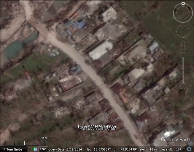
Port Salut, Haiti.

Port Salut, Haiti.


Before and after of Tiburon, Haiti.
The post Hurricane Matthew imagery via Google Crisis Response appeared first on Google Earth Blog.
Marriage in Rome
by Willi1 on Oct.09, 2016, under 3D Models, Argentina, Australia, Brazil, California, Denmark, England, Germany, Google Earth News, Google Earth Tips, Google Sky, Google maps, Hawaii, Indonesia, Ireland, Italy, Japan, Kenya, Mexico, Natural Landmarks, Netherlands, Sightseeing, Street Views, USA
Don’t look at me!
by cozmorio on Oct.09, 2016, under 3D Models, Argentina, Australia, Brazil, California, Denmark, England, Germany, Google Earth News, Google Earth Tips, Google Sky, Google maps, Hawaii, Indonesia, Ireland, Italy, Japan, Kenya, Mexico, Natural Landmarks, Netherlands, Sightseeing, Street Views, USA
Floods around the world as seen in Google Earth
by Timothy Whitehead on Oct.07, 2016, under 3D Models, Argentina, Australia, Brazil, California, Denmark, England, Germany, Google Earth News, Google Earth Tips, Google Sky, Google maps, Hawaii, Indonesia, Ireland, Italy, Japan, Kenya, Mexico, Natural Landmarks, Netherlands, Sightseeing, Street Views, USA
Flooding is a remarkably common phenomenon around the globe. Satellite imaging companies often try to capture imagery of the floods as such imagery is useful for governments and emergency services. DigitalGlobe, for example, has its First Look program through which it captures imagery and distributes it to emergency responders. Today we are looking at a few locations that we know about via the FirstLook program and where the imagery has since made its way into Google Earth. However, none of the imagery in today’s locations really captures the full scale of the events. This is due to a number of reasons:
- There is often no warning for floods. There may be warning for particular types of well-known weather systems such as cyclones and typhoons, or when there are heavy rains in a region the rivers downstream may be expected to flood. But even so, the severity of the flood is hard to predict.
- Floods follow rain and there are often cloudy conditions during and shortly after a flood, so it may take some time before there are suitable conditions for capturing imagery.
- In the case of flash floods the event is typically over before the location can be imaged, so all we can expect to see is the damage caused, such as houses or roads washed away.
- Google only puts high quality imagery in the default layer (more on this at the end of the post).
Eastern Sudan – July / August 2016
In late July and early August there were heavy rains and subsequent flooding in eastern Sudan. According to this article tens of thousands of people were affected and thousands of homes damaged or destroyed. There is a DigitalGlobe image of the town of Sennar and surrounding areas that was captured in response to the floods. Although there is a lot of standing water in the image, we could not find any flooded houses or evidence of houses washed away.

Skopje, Macedonia – August, 2016
In early August, 2016, Skopje Macedonia experienced severe flash flooding, killing at least 21 people. See this article for photos. In this case the imagery in Google Earth comes from CNES / Astrium. We can see some flooded areas, but the imagery does not quite cover the worst affected area (the northern parts of Chento).

Chetwynd, Canada – June, 2016
Chetwynd, Canada, experienced severe flooding in June, 2016 prompting a state of emergency to be declared. There is a DigitalGlobe image of Chetwynd captured after the event. Although we can see wet areas we could not find any washed away roads or bridges. We believe that the worst damage took place in areas not covered by the image.

Wuhan, China – July, 2016
The city of Wuhan was just one of many locations in China that experienced severe flooding in July. There is a CNES / Astrium image captured after the worst of the floods had already subsided, but the river is still very full, flooding some of the buildings along its banks.

In all the above locations we are looking at the imagery in the default layer. There is almost certainly more imagery hidden in ‘historical imagery’ that Google has chosen not to put in the default layer. However, Google has not updated ‘historical imagery’ since early June so we can’t see it. We should also mention Pekalongan City, Indonesia which experienced flooding in June, 2016. We can see bits of a Digital Globe image, but the parts we can see do not cover the affected area.
To see the locations above in Google Earth, download this KML file. We have marked out the extent of the relevant imagery in each location.
The post Floods around the world as seen in Google Earth appeared first on Google Earth Blog.