Tag: historical
Historical Street View imagery shows Detroit being reclaimed by nature
by Mickey Mellen on Jun.11, 2014, under 3D Models, Argentina, Australia, Brazil, California, Denmark, England, Germany, Google Earth News, Google Earth Tips, Google Sky, Google maps, Hawaii, Indonesia, Ireland, Italy, Japan, Kenya, Mexico, Natural Landmarks, Netherlands, Sightseeing, Street Views, USA
It was just recently that Google released their historical Street View feature, and we already have an amazing example of what can be found in there.
Using Google Street View’s historical imagery (and sometimes a bit of Bing imagery), the GooBing Detroit blog showcases some heartbreaking scenes around the city. For example, here is a series of photos from 2009-2013 on Exeter between Seven Mile and Penrose in northern Detroit.


The blog is both incredibly amazing and shockingly sad. I encourage you to check out the full blog to see the items that Alex has assembled on the page.
(via +Mike Elgan)
The post Historical Street View imagery shows Detroit being reclaimed by nature appeared first on Google Earth Blog.
Google releases historical Street View feature
by Mickey Mellen on Apr.24, 2014, under 3D Models, Argentina, Australia, Brazil, California, Denmark, England, Germany, Google Earth News, Google Earth Tips, Google Sky, Google maps, Hawaii, Indonesia, Ireland, Italy, Japan, Kenya, Mexico, Natural Landmarks, Netherlands, Sightseeing, Street Views, USA
We first considered this possibility a little over two years ago, and it’s finally here — historical Street View imagery!

Activating it is quite simple. While viewing imagery in Street View, simply click the clock in the upper-left part of the screen (as shown in the image above) to choose a different time. Note that this feature is rolling out in stages, and you may not yet have access to it.
The imagery dates back to 2007 in some areas, and could be quite useful in a number of scenarios, particularly as the collection continues to grow over time. This feature is not yet available in Google Earth (only on Google Maps), but presumably will be added at some point in the future. However, Google Earth does have the incredibly useful historical imagery feature. Having both of those available in one interface will be quite nice!
You can read more about this new feature over on the Google Lat Long Blog.
The post Google releases historical Street View feature appeared first on Google Earth Blog.
A look at twelve maps that changed the world
by Mickey Mellen on Jan.06, 2014, under 3D Models, Argentina, Australia, Brazil, California, Denmark, England, Germany, Google Earth News, Google Earth Tips, Google Sky, Google maps, Hawaii, Indonesia, Ireland, Italy, Japan, Kenya, Mexico, Natural Landmarks, Netherlands, Sightseeing, Street Views, USA
Maps have seen massive changes over the centuries. From rough, inaccurate maps thousands of years ago to Google Earth today, maps have changed in amazing ways. An article from The Atlantic summarizes those changes by showing twelve different maps that helped change the world.

The list goes back to the year 150 with the map above from Claudius Ptolemy and ends with Google Earth, with many interesting maps in between.
We’ve seen a handful of tools in Google Earth to help show old maps similar to some of these, such as maps from the Battle of Fort Sumter or the Battle of Gettysburg. You can also use Google Earth to view historical aerial imagery from the past few decades in many areas.
You can use this link to read The Atlantic article for yourself. Which of their twelve do you think was the most important of all time?
The post A look at twelve maps that changed the world appeared first on Google Earth Blog.
Exploring historical imagery with Google Timelapse
by Mickey Mellen on May.09, 2013, under 3D Models, Argentina, Australia, Brazil, California, Denmark, England, Germany, Google Earth News, Google Earth Tips, Google Sky, Google maps, Hawaii, Indonesia, Ireland, Italy, Japan, Kenya, Mexico, Natural Landmarks, Netherlands, Sightseeing, Street Views, USA
The historical imagery feature of Google Earth is an amazing tool, allowing you to browse imagery from a handful of different years for any given location on earth. Google has recently been working on a project with the USGS, NASA and TIME called Timelapse, and they’ve released it as a browser-based interactive timeline of imagery for selected locations on earth.

The process for developing this is stunning. From the Google Lat Long Blog:
We started working with the USGS in 2009 to make this historic archive of earth imagery available online. Using Google Earth Engine technology, we sifted through 2,068,467 images—a total of 909 terabytes of data—to find the highest-quality pixels (e.g., those without clouds), for every year since 1984 and for every spot on Earth. We then compiled these into enormous planetary images, 1.78 terapixels each, one for each year.
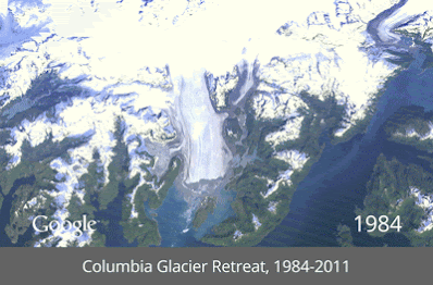
They’ve also created a handful of animated GIFs to show some of the timelapses, such as this one that features the Columbia Glacier Retreat from 1984-2011:
Additional animated GIFs can be found on their Google+ page.
You can go check it all out for yourself on the Google Timelapse page, or read more about it on TIME’s website or on the Google Lat Long Blog.
The post Exploring historical imagery with Google Timelapse appeared first on Google Earth Blog.