Author Archive
Winter is coming: 9 ways to enjoy it with Google
by Molly on Dec.04, 2021, under 3D Models, Argentina, Australia, Brazil, California, Denmark, England, Germany, Google Earth News, Google Earth Tips, Google Sky, Google maps, Hawaii, Indonesia, Ireland, Italy, Japan, Kenya, Mexico, Natural Landmarks, Netherlands, Sightseeing, Street Views, USA
As a native Oregonian, I thought living in California would be an incredible break from the nine months of rain I’d endured growing up. What I didn’t realize was that 70-degree winters felt…wrong. Where were the mittens? The down jackets? The occasional snowy days? I’ve since moved back to the Pacific Northwest, and I’ve had a renewed appreciation for winter weather.
In fact, I enjoy the chilly months of the year so much, I’ve put together a few ways to make the most of the cold weather.
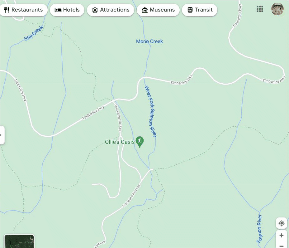
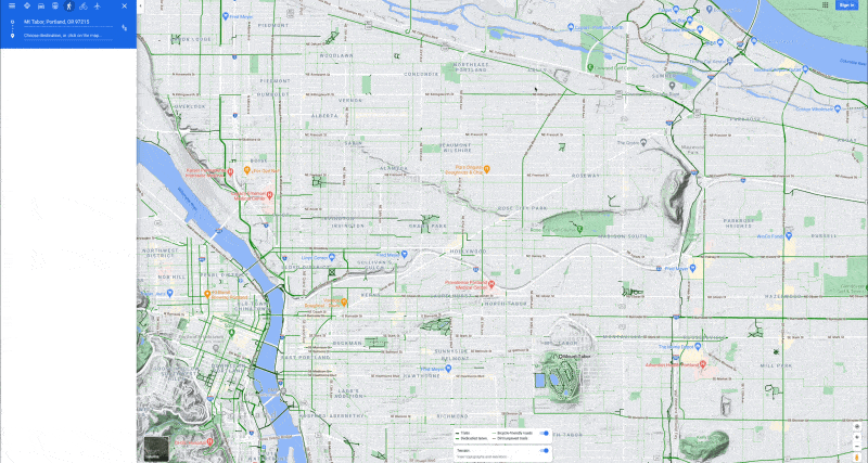
- I love snowshoeing, and I always want to find new trails. I use Google Maps to look for mountain biking and hiking trails that are covered in snow in the winter. (Just look for the hiking icons, or the light dash lines that indicate trails.) If I come across a good one, I label it on Maps so I know how to get back.
2. I’m a year-round runner, but once the temperature dips below 50 Fahrenheit and the roads get wet or icy, I need new gear — all of which I can find in one place using Google Shopping. You can select the Sports & Outdoors tab to browse — and turn on the deals filter for discounts.
3. And when I’m returning from a chilly run, I can use the Google Home app to turn on my Nest Thermostat before I get home, so I know I’m not wasting energy while I’m out and the house will be toasty when I come in. I also use Home & Away Routines so that Nest knows when I’m out and can adjust my temperature automatically.
4. OK fine, there’s one downside of winter weather, and that’s how early it gets dark. I use Google Assistant to notify me an hour before sunset so I can get outside for some sunshine before the sun goes down.
5. We’ve started cutting down our own Christmas tree, which is actually pretty easy to do. A quick Google Search for cutting down a tree on federal land will help you find a map (and how you can purchase a permit). Then you can just use Google Maps to take you to the right area.
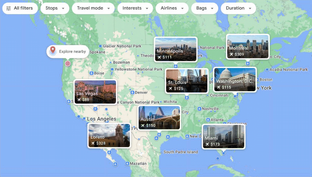
6. If I’m feeling really adventurous and ready to hit the slopes, I’ll check out the Explore tool on google.com/travel. I can set my home as the point of origin and then select “skiing” under the Interests filter and see what ski towns I can visit.
7. I love a good Google Alert to stay up to date on what’s going on locally. Once November rolls around, I set one for “Oregon winter festivals.”
8. Pixel cameras take incredible photos in dimly lit areas, so using Night Sight for shots of light displays or snowy nights is a no-brainer. And if you’ve already snagged a Pixel 6 or Pixel 6 Pro, those photos will look even better: The new Pixel camera lets in 2.5 times as much light as the Pixel 5, and you can try out the new Motion Mode setting to capture an artsy falling snow pic.
9. Most winter nights, I make a real fire — but when I don’t feel like hauling in wood, there’s always a YouTube version, complete with crackle.
A Local Guide uses Google Maps to help those without homes
by Molly on Mar.13, 2021, under 3D Models, Argentina, Australia, Brazil, California, Denmark, England, Germany, Google Earth News, Google Earth Tips, Google Sky, Google maps, Hawaii, Indonesia, Ireland, Italy, Japan, Kenya, Mexico, Natural Landmarks, Netherlands, Sightseeing, Street Views, USA
When Ashley Sundquist moved to Santa Monica, California four years ago, she noticed something different from the other places she’d lived. “I’ve lived in big cities much of my adult life; I’ve lived in Washington, D.C., Rome and New York City,” she says, “and none of those places prepared me for how many people here in Santa Monica are unhoused.” Santa Monica is part of the greater Los Angeles area, and according to city statistics, 907 people experience homelessness on any given night in the city; if you widen the area to include all of L.A., that number skyrockets to approximately 66,000.
During her morning commute, Ashley noticed how many people were living outside and gathering at the Santa Monica Public Library. Her gym was next door, and eventually, Ashley started crossing the street to say hello. Soon, she’d made connections with library employees and the people without homes who gathered there, and she began looking for ways to help.
She also became friends with a man named Joe, an unhoused member of the community who was often at the library. Joe mentioned he struggled with getting lost, which inspired her to turn to Google Maps and the app’s list feature. You can use this to create a list of places, like your favorite restaurants or places you want to visit on vacation. As an active member of the Local Guides program, a global community of contributors on Google Maps, Ashley was no stranger to sharing helpful information about her community with others.
So Ashley started creating lists for people in need. She made lists of resources for young people experiencing homelessness, food banks and restaurants that accept EBT cards. To make things even easier to find, Ashley bought the domains “lashelters.org” and “lashelters.com,” which send visitors to these lists. “Now when anybody in the world goes to one of those websites, they’ll see these maps,” Ashley says. Joe and Ashley also became friends, and he helped get the word out about the websites.

Ashley’s Google Maps list for youth resources in L.A.
When the COVID-19 crisis hit, Ashley had to pivot. Right away she volunteered her time to teach caseworkers (via Google Meet) how to create their own lists in Google Maps. “I walked them through step-by-step how to search for locations, update the description and share the URL,” she says. She also created a list to help people find free Wi-Fi after many restaurants, coffee shops and other places that offer internet access closed their doors, and another list to help people find transportation to shelters when COVID-19 precautions altered bus schedules.
Still, things changed so dramatically so quickly; she wanted to do more. “Toward the end of last March, I realized things weren’t going to go back to the way they were anytime soon. I knew how our outreach efforts were going to have to be different.” She started consulting with local agencies to gather information for more lists, or update the ones she’d already made with new COVID-19-related restrictions, changing hours or other stipulations.
“I hope this can help people get through their day with dignity and humanity. That’s what we’re all trying to do right now.”
Eventually she wanted to try getting the information she’d gathered out in person. In May, she started volunteering at a weekly dinner serving some 150 unhoused neighbors at her local Salvation Army. Soon, she began leading dinners and helped her church get more involved. “We have 20 or so volunteers, with masks, temperature checks, distanced, all of that,” she says. “It’s a huge undertaking but I feel like it gives me a captive audience. Our team can bring a little light and love into a very dark place. We can help people find local resources on the Google Maps lists.”
Ashley looks through Google Maps lists with her friend Joe, whom she met through her work with unhoused people. Joe is also an advocate for his community.
Ashley greets everyone as they wait in line for their meal and makes an effort to learn names. “It might be the only time someone speaks to them or uses their name that week,” she explains. “I really work to build a rapport so then I can say to them, ‘Oh I see you’re having trouble getting this or finding that.’” Then she takes out her phone and shares her Google Maps lists on the spot. Ashely notes that many people without homes have smartphones, which act as their lifelines, but if she’s speaking with someone without one, Ashley uses her own to access her lists to call and try to help get them what they need — whether it’s a spot at a shelter or a no-cost doctor appointment.
“People are dealing with homelessness, trauma, hunger, mental health issues, technology barriers...I feel like the least I can do is make the available resources easier to find with a Google Maps list,” she says.
Ashley’s hope is that her neighbors feel seen and cared for, and that the Google Maps lists help them meet their basic needs. “I don’t think people realize how tremendously difficult it is to get help when you’re experiencing homelessness,” she says. “I hope this can help people get through their day with dignity and humanity. That’s what we’re all trying to do right now.”
Make your own turkey trot with Google Maps
by Molly on Nov.24, 2020, under 3D Models, Argentina, Australia, Brazil, California, Denmark, England, Germany, Google Earth News, Google Earth Tips, Google Sky, Google maps, Hawaii, Indonesia, Ireland, Italy, Japan, Kenya, Mexico, Natural Landmarks, Netherlands, Sightseeing, Street Views, USA
Every Thanksgiving, before I settle into the couch to watch football or load my plate with multiple servings of stuffing, there’s another tradition I have to accomplish first: a turkey trot.
If you don’t already know, a turkey trot is a Thanksgiving Day run. It’s usually a casual way to log a few miles before sitting down for the big meal. There are lots of community-led, organized Turkey Trots, but plenty of people do them casually as well. I’ve done them with running clubs, alongside family and friends and even participated in an official race or two.
Even though I’m practicing social distancing this year, the turkey trot isn’t canceled. Instead, thanks to some help from Google Maps, it will be a semi-solo operation, with the option for friends and family—or really, anyone in the area—to virtually run “along” the route with me. Below, you can follow a few easy steps to create your own turkey trot as well. (These directions are for using Google Maps on desktop.)
Step 1. First, open Google Maps and select the hamburger menu at left (the three lines in a row). When that opens, choose “Terrain.” Then, the map at right will show you the topography of your location, which is helpful if you want to avoid (or add) some hills to your run.
I also found it helpful to select the “Bicycling” option in this panel. This highlights the bike lanes and trails in your area, and I’ve found it particularly useful to find paths that cut through parks that are great for cyclists and pedestrians. Another great way to get an idea of what your run will look like is to jump into Street View so you can get a more accurate idea of what you’ll be running through.
Step 2. I’m going to start and end my race at a park, but you can start from wherever you want. I decided an eight-mile run sounds right, so I chose a half point of four miles on the map. This is a bit of trial and error (“Oops, that was only three miles away, and this point is about five”) until you find the best spot. And of course, this doesn’t have to be exact if you’re not trying to be too official.
When you’re doing this, make sure you choose the “walking” icon, and also know that you can select the direction line on Google Maps to make the path a little longer or shorter. For example, I saw a bike trail that went through a park and dragged the dotted line through it. Just play around with this until you find the halfway mark that works for you.
Step 3. On the left-hand side, choose “add destination,” and re-enter your original starting point. Follow the instructions from step three again to drag and adjust your path as desired to get to the mileage you want. You can also take advantage of some of Maps’ new features if you want to make sure you get your fill of fall foliage. Or if you want to run by the homes of friends and family for a quick hello as you go, use Maps’ list feature to mark them, or any other landmarks that you want to include in the route.
Step 4. After you’ve completed creating your route, you can choose “Send directions to your phone” so you’ll have the map while you’re running. And if you select “Details,” you’ll see a share icon in the upper right-hand corner of this panel. There, you’ll get a link that you can share with family and friends. This way, they can try and recreate a similar path in their own neighborhood.
Step 5. When I’m running a specific path like this, I like to turn on the detailed voice guide feature, which gives you more frequent alerts for navigation. It was built to help people who are visually impaired, but it’s also great for runners who don’t want to constantly glance at their phone for directions. In your Google Maps settings, select “Navigation,” and you’ll see an option at the bottom of the list under “Walking options” for “Detailed voice guidance.”
Step 6. Now this is optional, but if you really want the full turkey trot experience, you can all choose a time to start your race and “run” together. There are a handful of apps that let you track and time your run. You can be as competitive (or non-competitive) as you want, with prizes for winners, or most-spirited. Get creative and add a scavenger hunt element to it: Runners get points for photos of Thanksgiving decorations, or local landmarks. Make it yours, and more importantly, make it fun.
Explore new sites, relive old hikes for National Park Week
by Molly on Apr.22, 2020, under 3D Models, Argentina, Australia, Brazil, California, Denmark, England, Germany, Google Earth, Google Earth News, Google Earth Tips, Google Sky, Google maps, Hawaii, Indonesia, Ireland, Italy, Japan, Kenya, Mexico, Natural Landmarks, Netherlands, Sightseeing, Street Views, USA
Every year, I try to visit a new National Park, or at least start planning my trip to one. That’s a little more difficult right now, but given that it’s National Park Week, I decided to try and keep with my tradition by using Google tools to satisfy my wanderlust.
Explore new places and parks
This year, I’m heading to g.co/nationalparks, a Google Arts & Culture project developed in collaboration with National Park Service that takes you on guided tours narrated by park rangers from the Kenai Fjords, Hawai'i Volcanoes, Carlsbad Caverns, Bryce Canyon and Dry Tortugas. I can also visit historical sites that I’ve never been to before, like Eleanor Roosevelt’s woodsy home in Hyde Park, New York or Thomas Edison’s camping sites (which, to me, look a little more like glamping). There are more than 100 Street View historical tours to choose from, and collections that let you discover Native American craft work or fossils from archeological digs.
Afterward, I’ll take an in-depth tour of some of the National Parks of the United States and wander through a few of the most-loved ones recommended by our community of Local Guides in two popular Google Earth Voyager stories. I plan on rounding out the week with a new YouTube series from the Google Earth team that travels to National Parks across the country, literally “zooming” you into places like Elephant Hill in Canyonlands National Park and Kanarraville Falls in Zion National Park. There’s even a new Global National Parks quiz to test your geo-knowledge.

All of these things help an outdoor enthusiast who’s stuck inside (for the time being) to find unknown landscapes or get inspiration for their next trip. Perhaps for the most well-traveled out there, they’re a way to remember a favorite adventure.
Or revisit old favorites
Before I venture into the unknown, I decided to take a trip down memory lane (or rather, memory trail), and re-experience some of my favorite hikes in National Parks with the help of Google Street View, and anyone can join me—starting with Bright Angel Trail in the Grand Canyon. Saving the uphill journey for the second half of a hike is something my legs will never forget, but it remains one of my favorite National Parks memories. And thanks to Street View, I can recreate the journey … with fewer water breaks, probably.
I can also make my way up Garfield Peak in Crater Lake National Park (which I hiked during a camping trip where I first met my husband) and make as many nostalgic pit stops along the way as I want.
And last summer, my family and I all vacationed in Acadia National Park. Now that we can’t physically see one another, I’m even more grateful we went. One of my favorite memories was hiking along the park’s easternmost edge, the Great Head Trail, with my husband and meeting my family on Sand Beach, a journey I’m happily retaking via Street View … and maybe on our weekly family video call, we’ll all “hike” it together.
Explore new sites, relive old hikes for National Park Week
by Molly on Apr.22, 2020, under 3D Models, Argentina, Australia, Brazil, California, Denmark, England, Germany, Google Earth, Google Earth News, Google Earth Tips, Google Sky, Google maps, Hawaii, Indonesia, Ireland, Italy, Japan, Kenya, Mexico, Natural Landmarks, Netherlands, Sightseeing, Street Views, USA
Every year, I try to visit a new National Park, or at least start planning my trip to one. That’s a little more difficult right now, but given that it’s National Park Week, I decided to try and keep with my tradition by using Google tools to satisfy my wanderlust.
Explore new places and parks
This year, I’m heading to g.co/nationalparks, a Google Arts & Culture project developed in collaboration with National Park Service that takes you on guided tours narrated by park rangers from the Kenai Fjords, Hawai'i Volcanoes, Carlsbad Caverns, Bryce Canyon and Dry Tortugas. I can also visit historical sites that I’ve never been to before, like Eleanor Roosevelt’s woodsy home in Hyde Park, New York or Thomas Edison’s camping sites (which, to me, look a little more like glamping). There are more than 100 Street View historical tours to choose from, and collections that let you discover Native American craft work or fossils from archeological digs.
Afterward, I’ll take an in-depth tour of some of the National Parks of the United States and wander through a few of the most-loved ones recommended by our community of Local Guides in two popular Google Earth Voyager stories. I plan on rounding out the week with a new YouTube series from the Google Earth team that travels to National Parks across the country, literally “zooming” you into places like Elephant Hill in Canyonlands National Park and Kanarraville Falls in Zion National Park. There’s even a new Global National Parks quiz to test your geo-knowledge.
All of these things help an outdoor enthusiast who’s stuck inside (for the time being) to find unknown landscapes or get inspiration for their next trip. Perhaps for the most well-traveled out there, they’re a way to remember a favorite adventure.
Or revisit old favorites
Before I venture into the unknown, I decided to take a trip down memory lane (or rather, memory trail), and re-experience some of my favorite hikes in National Parks with the help of Google Street View, and anyone can join me—starting with Bright Angel Trail in the Grand Canyon. Saving the uphill journey for the second half of a hike is something my legs will never forget, but it remains one of my favorite National Parks memories. And thanks to Street View, I can recreate the journey … with fewer water breaks, probably.
I can also make my way up Garfield Peak in Crater Lake National Park (which I hiked during a camping trip where I first met my husband) and make as many nostalgic pit stops along the way as I want.
And last summer, my family and I all vacationed in Acadia National Park. Now that we can’t physically see one another, I’m even more grateful we went. One of my favorite memories was hiking along the park’s easternmost edge, the Great Head Trail, with my husband and meeting my family on Sand Beach, a journey I’m happily retaking via Street View … and maybe on our weekly family video call, we’ll all “hike” it together.
Porsche Taylor puts women in the driver’s seat
by Molly on Mar.25, 2020, under 3D Models, Argentina, Australia, Brazil, California, Denmark, England, Germany, Google Earth News, Google Earth Tips, Google Sky, Google maps, Hawaii, Indonesia, Ireland, Italy, Japan, Kenya, Mexico, Natural Landmarks, Netherlands, Sightseeing, Street Views, USA
Porsche Taylor’s first time riding a motorcycle alone could have gone better. “That first ride, I had absolutely nothing on right: My helmet was too big, I didn’t own a jacket. I might have had on some baseball gloves; everything was just totally upside-down wrong,” she says. “But I wasn’t afraid, it was exhilarating. It was trying something new, being in control. It was that initial feeling of the freedom of the wind.”
Porsche was one of the participants in the Women Riders World Relay, a relay ride that spanned the globe, beginning in February 2019 in Scotland and ending February 2020 in London. WRWR organizers used Google products like Maps, Sheets and Translate to make sure riders not only had constant, up-to-date access to their routes, but also were able to explore and connect with one another along the way.
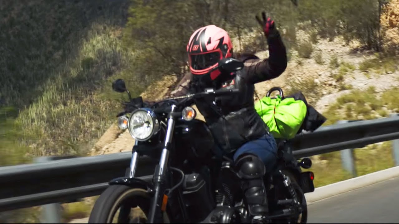
“The whole team did phenomenally with the amount of time they had to put together the route and figure out the baton passes,” says Porsche. Google Maps was particularly useful for creating Porsche’s route. She and her fellow riders rode from Sept. 25 to Oct. 14, starting in Maine and heading west across the Canadian border, then down through the Southwest to the Mexican border in Texas. They crossed the country, occasionally riding through snowstorms and dropping temperatures. “When you consider the seasons we were riding through, it was a definite challenge for organizers to find routes that weren’t closed down.”
While Google Maps could help the riders along their journey, it couldn’t do anything about inclement weather. “I quit about four times,” laughs Porsche. “Riding in the cold is not my favorite thing to do. But it was a positive experience all the way around; I don’t know that I would ride in the freezing cold again, but I would do a ride with those women again for sure. I always say the bonds are built on the ground: You’re going to love the folks you ride with to death or you won’t be so cool, and I’m happy to say I love those ladies to death.”
Porsche is vocal about the need for more representation for women in the motor sports community, and she says that things like social media visibility and technical tools like Google Hangouts have helped women who may have felt alone in their shared passion find each other. This idea is in part what inspired her to found Black Girls Ride, a magazine and community originally launched as a place for women of color who ride, which has since grown to include all women. What inspired her to launch Black Girls Ride was the lack of representation she saw when she first started riding—especially in long-distance riding. Traditionally, women filled support roles during these cross-country expeditions, taking a literal backseat to men. In fact, Porsche’s first experience on a bike was sitting behind a man, on the back of her cousin’s bike. “I didn’t so much like the feeling of being a passenger...but I loved the feeling of riding.”
Thanks to women like Porsche and the WRWR riders, the world of motor sports is changing. “Women have become fearless and bold enough to take long distance biking trips on their own. We’re witnessing the explosion of the all-female long distance ride, where women take it upon themselves to create rides that cater to them instead of being a subset of an all-male ride. It’s where we get to take our power back.”
Talking about these rides and seeing women taking them via social media and internet communities are crucial, says Porsche, who also mentions using Google Hangouts to connect with riders across the country. “You’re able to see the growth of female riders; women taking these long distance trips and riding solo have always been there—there are women riding today who have been doing this since the 60s—but social media is now shining a light on them.”
That increased visibility is part of Porsche's work with Black Girls Ride. “I knew from riding in LA that there were more of us than the community would admit to. There was no representation in mainstream media, even for women who were riding professionally, there was very little to nothing,” Porsche says. Now "women all over the world are connecting to the Black Girls Ride brand. We have readers in London, Nigeria, France, just about every country you can name. I’m motivated by these women.” Black Girls Ride has become more than a publication, hosting trainings, workshops and events. And while both men and women are included, it’s Porsche’s focus to make sure women riders are invited to the table and that they are given the same representation, advertising and sponsorship opportunities.
Most of all, she just wants women to feel welcome in this world. “It’s always been my goal to create safe spaces for women to ask questions and get the help they need without fear of ridicule,” she says. “And I’m glad I can be a part of creating that.”
Learn more about the women behind WRWR and how they planned their relay at goo.gle/womenriders.
Porsche Taylor puts women in the driver’s seat
by Molly on Mar.25, 2020, under 3D Models, Argentina, Australia, Brazil, California, Denmark, England, Germany, Google Earth News, Google Earth Tips, Google Sky, Google maps, Hawaii, Indonesia, Ireland, Italy, Japan, Kenya, Mexico, Natural Landmarks, Netherlands, Sightseeing, Street Views, USA
Porsche Taylor’s first time riding a motorcycle alone could have gone better. “That first ride, I had absolutely nothing on right: My helmet was too big, I didn’t own a jacket. I might have had on some baseball gloves; everything was just totally upside-down wrong,” she says. “But I wasn’t afraid, it was exhilarating. It was trying something new, being in control. It was that initial feeling of the freedom of the wind.”
Porsche was one of the participants in the Women Riders World Relay, a relay ride that spanned the globe, beginning in February 2019 in Scotland and ending February 2020 in London. WRWR organizers used Google products like Maps, Sheets and Translate to make sure riders not only had constant, up-to-date access to their routes, but also were able to explore and connect with one another along the way.
“The whole team did phenomenally with the amount of time they had to put together the route and figure out the baton passes,” says Porsche. Google Maps was particularly useful for creating Porsche’s route. She and her fellow riders rode from Sept. 25 to Oct. 14, starting in Maine and heading west across the Canadian border, then down through the Southwest to the Mexican border in Texas. They crossed the country, occasionally riding through snowstorms and dropping temperatures. “When you consider the seasons we were riding through, it was a definite challenge for organizers to find routes that weren’t closed down.”
While Google Maps could help the riders along their journey, it couldn’t do anything about inclement weather. “I quit about four times,” laughs Porsche. “Riding in the cold is not my favorite thing to do. But it was a positive experience all the way around; I don’t know that I would ride in the freezing cold again, but I would do a ride with those women again for sure. I always say the bonds are built on the ground: You’re going to love the folks you ride with to death or you won’t be so cool, and I’m happy to say I love those ladies to death.”
Porsche is vocal about the need for more representation for women in the motor sports community, and she says that things like social media visibility and technical tools like Google Hangouts have helped women who may have felt alone in their shared passion find each other. This idea is in part what inspired her to found Black Girls Ride, a magazine and community originally launched as a place for women of color who ride, which has since grown to include all women. What inspired her to launch Black Girls Ride was the lack of representation she saw when she first started riding—especially in long-distance riding. Traditionally, women filled support roles during these cross-country expeditions, taking a literal backseat to men. In fact, Porsche’s first experience on a bike was sitting behind a man, on the back of her cousin’s bike. “I didn’t so much like the feeling of being a passenger...but I loved the feeling of riding.”
Thanks to women like Porsche and the WRWR riders, the world of motor sports is changing. “Women have become fearless and bold enough to take long distance biking trips on their own. We’re witnessing the explosion of the all-female long distance ride, where women take it upon themselves to create rides that cater to them instead of being a subset of an all-male ride. It’s where we get to take our power back.”
Talking about these rides and seeing women taking them via social media and internet communities are crucial, says Porsche, who also mentions using Google Hangouts to connect with riders across the country. “You’re able to see the growth of female riders; women taking these long distance trips and riding solo have always been there—there are women riding today who have been doing this since the 60s—but social media is now shining a light on them.”
That increased visibility is part of Porsche's work with Black Girls Ride. “I knew from riding in LA that there were more of us than the community would admit to. There was no representation in mainstream media, even for women who were riding professionally, there was very little to nothing,” Porsche says. Now "women all over the world are connecting to the Black Girls Ride brand. We have readers in London, Nigeria, France, just about every country you can name. I’m motivated by these women.” Black Girls Ride has become more than a publication, hosting trainings, workshops and events. And while both men and women are included, it’s Porsche’s focus to make sure women riders are invited to the table and that they are given the same representation, advertising and sponsorship opportunities.
Most of all, she just wants women to feel welcome in this world. “It’s always been my goal to create safe spaces for women to ask questions and get the help they need without fear of ridicule,” she says. “And I’m glad I can be a part of creating that.”
Learn more about the women behind WRWR and how they planned their relay at goo.gle/womenriders.
One man’s mission to add civil rights history to Google Maps
by Molly on Feb.14, 2020, under 3D Models, Argentina, Australia, Brazil, California, Denmark, England, Germany, Google Earth News, Google Earth Tips, Google Sky, Google maps, Hawaii, Indonesia, Ireland, Italy, Japan, Kenya, Mexico, Natural Landmarks, Netherlands, Sightseeing, Street Views, USA
“I think in another life, I would have been a private investigator,” says Paul Kang. The Nashville resident is a paralegal for an immigration law firm, but it’s his hobby as a Local Guide on Google Maps that’s brought out his inner detective, turning him into something of a historian.
Paul and his family moved to Tennessee in 2012, and it was out of necessity that he was first introduced to Google Maps and soon after Local Guides, the community of everyday people who are passionate about sharing their experiences on Google Maps with reviews, photos, videos and more. Their efforts end up making Maps better for everyone. “My wife wanted to know where the post office near her work was, so I looked it up and sent her the map listing,” he says. “And when she went there, she told me it was all closed up.” The post office wasn’t open for business anymore. This sort of thing happened a few more times, and after becoming slightly frustrated, Paul realized he could use Google Maps to edit information. “I started closing things down, replacing duplicate listings,” he says. Eventually, Paul was doing much more than correcting listings. In 2017, the 1955 murder of Emmett Till resurfaced in the news when an interview with the woman who’d accused Till of harassing her—which led her husband and an accomplice to murder Till—admitted it wasn’t true. The tragic, senseless killing of the 14-year-old boy had been a catalyst in the civil rights movement, and the confession reignited interest in the story for Americans everywhere.
Paul first learned about what happened to Emmett Till when he was a young adult. “I think one of the things I still remember is that the jury acquitted Till’s murderers in 59 minutes, but that they would have [done it] faster if they hadn’t all gone together to get a bottle of pop before rendering the verdict.”
When he used Google Maps to try and find the site where Till’s body was found, a listing appeared—but didn’t seem like it was in the right spot according to what Paul had read. After using historical resources to learn more about the location, he was able to find it himself on Google Maps—and he decided that everyone else should be able to as well, so he loaded up his wife and kids and started the two-hour road trip south.
“I just thought, you know what, I’m going to do this, I’m doing to drive my whole family down there,” Paul says. When they got there, he says they discovered a museum dedicated to Emmett Till, but it was only open by appointment--information that hadn’t been listed in Google Maps. Fortunately, the museum was holding an event, and Paul’s family was able to go in. What Paul didn’t realize is how important the experience was for his wife, who was learning about Emmett Till for the first time. “We talked about it as she was going through it. It was shocking to her. It was a big download of information for her, and I know it’s stuck with her and informs her when she’s reading the news today, too.”
Using a 360-degree camera, Paul also took Street View photos of the site where Till’s body was found, and updated the Google Maps data so others can find it. He was even able to find the barn where Till was tortured and added that information to Maps.
Paul's gone on to add more historical information to Google Maps; he thinks he’s added some 50 historic landmarks, give or take. In 2018, for the 50th anniversary of Dr. Martin Luther King, Jr.’s assassination, various sites and memorials in Memphis were being constructed. “I waited to see if the city or some nonprofit maybe was going to add them to Google Maps, but I didn’t see anything,” he says. “So I just started adding them.”
He also made a point to update information about other memorials to Dr. King, including “I Have Been to the Mountaintop,” a sculpture unveiled in 1976 that was moved to a more prominent part of downtown Memphis. I AM A MAN plaza, an open air installation that opened in 2018 and dedicated to the sanitation workers’ strike of 1968, also wasn’t on Google Maps; Paul made sure both of these sites would surface, complete with historic information. Once when he went to take photos for Street View with his 360-degree camera, a few police officers acting as security at a site asked what he was doing. “I was like, ‘I’m making sure this gets on Google Maps, so people can find it!’”
News archives and web research power Paul’s exploration of the history of his new state and he says there’s work to be done to make sure this information remains accessible for future generations. “A lot of the websites cataloging information about these kinds of places with descriptions and photos are volunteer-led,” he says. “What if they decide not to or forget to renew their domain? Those websites could go away.”
Fortunately, Paul’s work won’t be going anywhere. “Even if all these websites go away, Google Maps will still be here.”