Author Archive
Redefining what a map can be with new information and AI
by Dane Glasgow on Mar.30, 2021, under 3D Models, Argentina, Australia, Brazil, California, Denmark, England, Germany, Google Earth News, Google Earth Tips, Google Sky, Google maps, Hawaii, Indonesia, Ireland, Italy, Japan, Kenya, Mexico, Natural Landmarks, Netherlands, Sightseeing, Street Views, USA
Sixteen years ago, many of us held a printout of directions in one hand and the steering wheel in the other to get around— without information about the traffic along your route or details about when your favorite restaurant was open. Since then, we’ve been pushing the boundaries of what a map can do, propelled by the latest machine learning. This year, we’re on track to bring over 100 AI-powered improvements to Google Maps so you can get the most accurate, up-to-date information about the world, exactly when you need it. Here's a snapshot of how we're using AI to make Maps work better for you with a number of updates coming this year.
Navigate indoors with Live View
We all know that awkward moment when you're walking in the opposite direction of where you want to go — Live View uses AR cues to avoid just that. Live View is powered by a technology called global localization, which uses AI to scan tens of billions of Street View images to understand your orientation. Thanks to new advancements that help us understand the precise altitude and placement of objects inside a building, we’re now able to bring Live View to some of the trickiest-to-navigate places indoors: airports, transit stations and malls.
If you’re catching a plane or train, Live View can help you find the nearest elevator and escalators, your gate, platform, baggage claim, check-in counters, ticket office, restrooms, ATMs and more. Arrows and accompanying directions will point you the right way. And if you need to pick something up from the mall, use Live View to see what floor a store is on and how to get there so you can get in and out in a snap. Indoor Live View is live now on Android and iOS in a number of malls in Chicago, Long Island, Los Angeles, Newark, San Francisco, San Jose, and Seattle. It starts rolling out in the coming months in select airports, malls, and transit stations in Tokyo and Zurich, with more cities on the way.
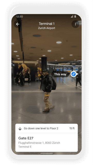
Find your way inside airports, train stations, and malls with Indoor Live View
Plan ahead with more information about weather and air quality
With the new weather layer, you can quickly see current and forecasted temperature and weather conditions in an area — so you’ll never get caught in the rain without an umbrella. And the new air quality layer shows you how healthy (or unhealthy) the air is — information that’s especially helpful if you have allergies or are in a smoggy or fire-prone area. Data from partners like The Weather Company, AirNow.gov and the Central Pollution Control Board power these layers that start rolling out on Android and iOS in the coming months. The weather layer will be available globally and the air quality layer will launch in Australia, India, and the U.S., with more countries to come.
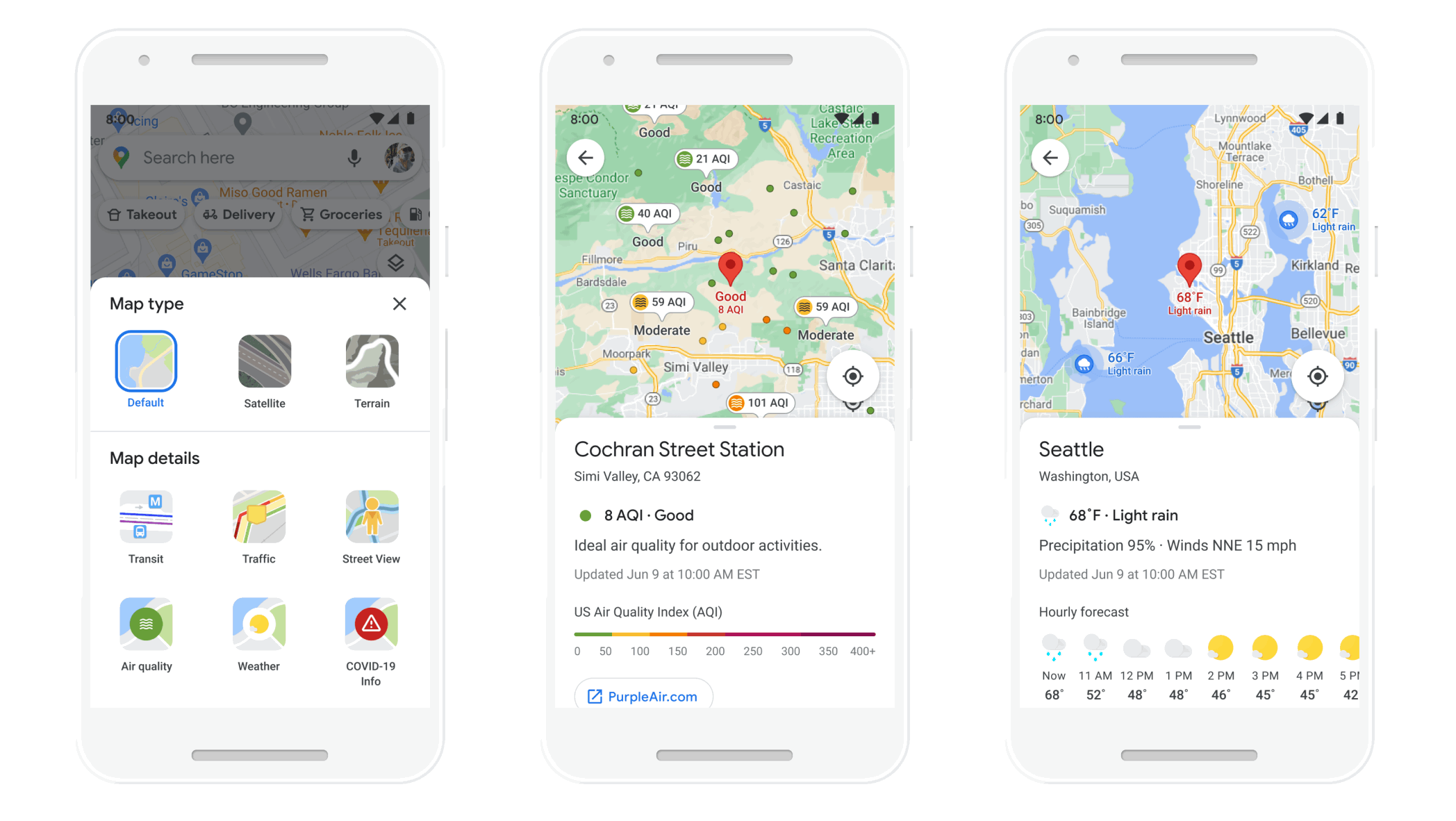
See helpful air quality and weather information with new layers in Google Maps
Find more eco-friendly options to get around
With insights from the U.S. Department of Energy’s National Renewable Energy Lab, we’re building a new routing model that optimizes for lower fuel consumption based on factors like road incline and traffic congestion. This is all part of the commitment we made last September to help one billion people who use our products take action to reduce their environmental footprint. Soon, Google Maps will default to the route with the lowest carbon footprint when it has approximately the same ETA as the fastest route. In cases where the eco-friendly route could significantly increase your ETA, we’ll let you compare the relative CO2 impact between routes so you can choose. Always want the fastest route? That’s OK too — simply adjust your preferences in Settings. Eco-friendly routes launch in the U.S. on Android and iOS later this year, with a global expansion on the way.
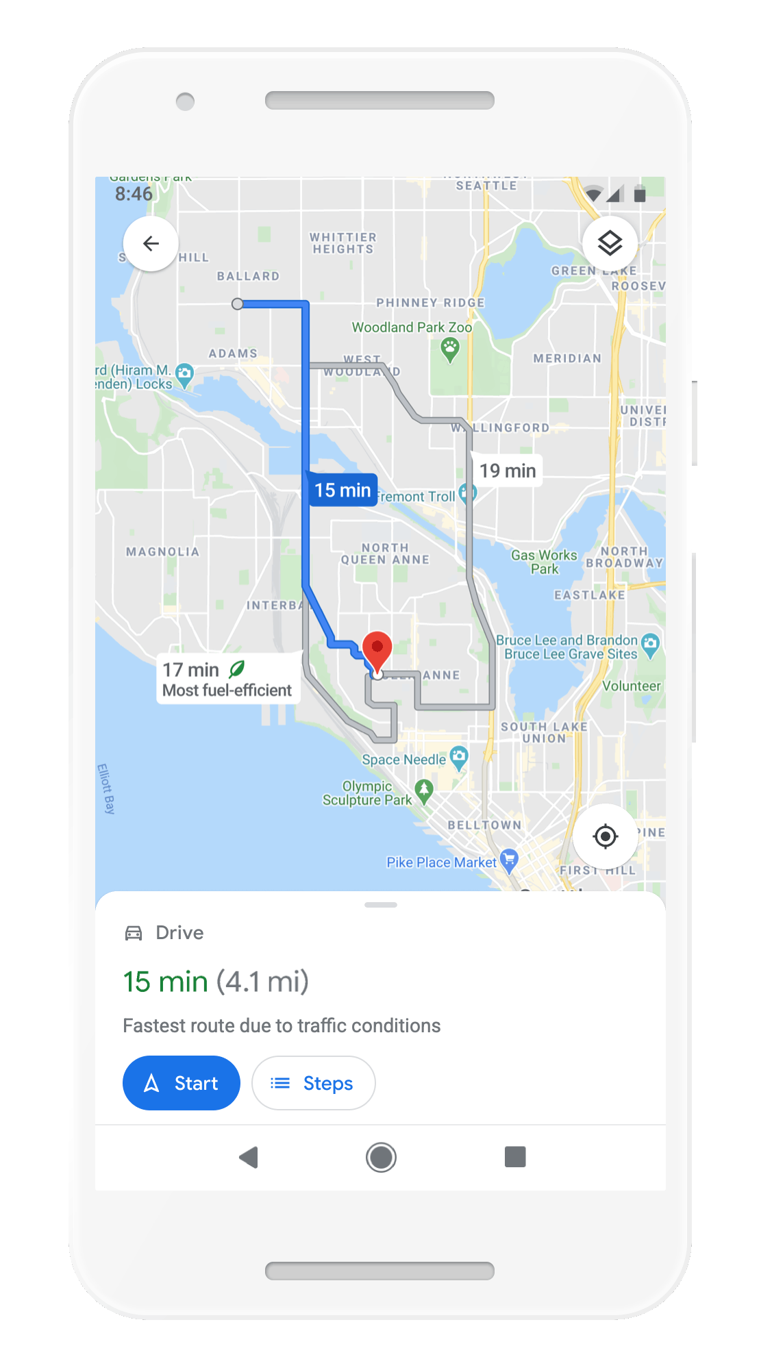
More eco-friendly routes let you choose the route with the lowest carbon footprint
From Amsterdam to Jakarta, cities around the world have established low emission zones — areas that restrict polluting vehicles like certain diesel cars or cars with specific emissions stickers — to help keep the air clean. To support these efforts, we’re working on alerts to help drivers better understand when they’ll be navigating through one of these zones. You can quickly know if your vehicle is allowed in the area, choose an alternative mode of transportation, or take another route. Low emission zone alerts launch this June in Germany, the Netherlands, France, Spain, and the UK on Android and iOS, with more countries coming soon.
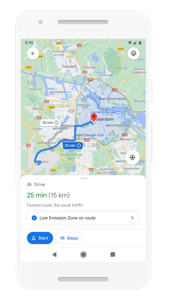
Quickly know if your vehicle is allowed in the area, choose an alternative mode of transportation, or take another route with low emission zone alerts
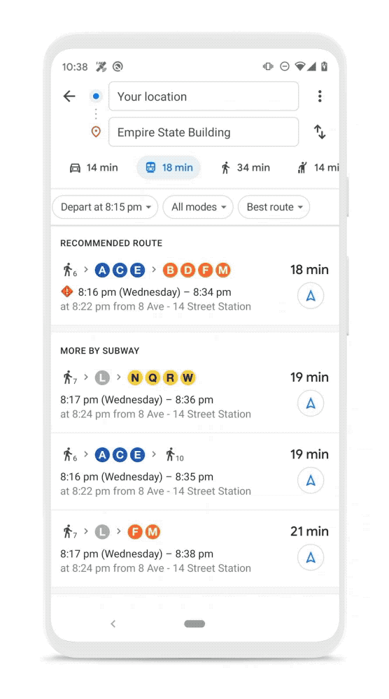
But we know that getting around sustainably goes beyond driving. So we’re making it easier to choose more sustainable options when you’re on the go. Soon you’ll get a comprehensive view of all routes and transportation modes available to your destination — you can compare how long it’ll take to get there by car, transit or bike without toggling between tabs. Using advanced machine learning models, Maps will automatically prioritize your preferred modes — and even boost modes that are popular in your city. For example, if you bike a lot, we’ll automatically show you more biking routes. And if you live in a city like New York, London, Tokyo, or Buenos Aires where taking the subway is popular, we’ll rank that mode higher. This rolls out globally in the coming months on Android and iOS.
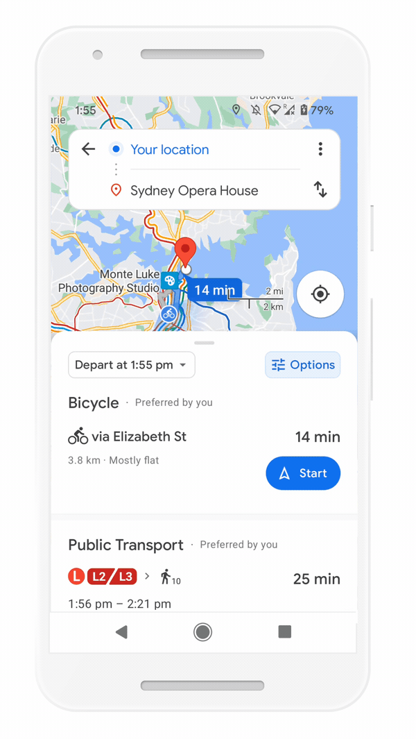
Easily compare different routes and modes of transportation with the new directions experience
Save time with curbside grocery pickup on Maps
Delivery and curbside pickup have grown in popularity during the pandemic — they’re convenient and minimize contact. To make this process easier, we’re bringing helpful shopping information to stores’ Business Profiles on Maps and Search, like delivery providers, pickup and delivery windows, fees, and order minimums. We’re rolling this out on mobile Search starting with Instacart and Albertsons Cos. stores in the U.S., with plans to expand to Maps and other partners.

Check out helpful information about grocery delivery providers, pickup and delivery windows, fees, and order minimums
This summer, we’re also teaming up with U.S. supermarket Fred Meyer, a division of The Kroger Co., on a pilot in select stores in Portland, Oregon to make grocery pickup easier. After you place an order for pickup on the store’s app, you can add it to Maps. We’ll send you a notification when it’s time to leave, and let you share your arrival time with the store. Your ETA is continuously updated, based on location and traffic. This helps the store prioritize your order so it’s ready as soon as you get there. Check in on the Google Maps app, and they’ll bring your order right out for a seamless, fast, no-contact pickup.

Track your grocery order status, share your ETA, and let the store know you've arrived - all from Google Maps
All of these updates are possible thanks to AI advancements that have transformed Google Maps into a map that can reflect the millions of changes made around the world every day — in the biggest cities and the smallest towns. Whether you’re getting around, exploring an area, or knocking out errands, let Google Maps help you find your way.
Google Maps updates to get you through the holidays
by Dane Glasgow on Nov.17, 2020, under 3D Models, Argentina, Australia, Brazil, California, Denmark, England, Germany, Google Earth News, Google Earth Tips, Google Sky, Google maps, Hawaii, Indonesia, Ireland, Italy, Japan, Kenya, Mexico, Natural Landmarks, Netherlands, Sightseeing, Street Views, USA
This year, we’ve made it easier to find information that helps you stay safe, up-to-date, and connected. Since the start of the pandemic, we’ve added nearly 250 new features and improvements to Google Maps to help you adapt to this new normal—from live busyness information for millions of places, to the ability to easily see critical health and safety information at a glance. And we’re continuing to invest in ways to keep information in Maps fresh, with over 50 million updates made to the map each day. Even as the holidays approach, we don’t plan on slowing down. If you need to be out and about this holiday season, here are four ways that Google Maps can help you get around safely and get things done.
Get around
Whether you’re heading out of town or staying local, keeping a pulse on the latest COVID trends can help you stay safe. Since we launched the COVID layer, it’s helped nearly 10 million people get critical information about COVID-19 right from Google Maps.
We’re rolling out two new improvements in the coming weeks. The updated COVID layer on Android and iOS will soon show more information, including all-time detected cases in an area, along with quick links to COVID resources from local authorities. This is especially handy if you’re heading out of town and need to get up to speed about the local guidelines, testing sites and restrictions in another city.
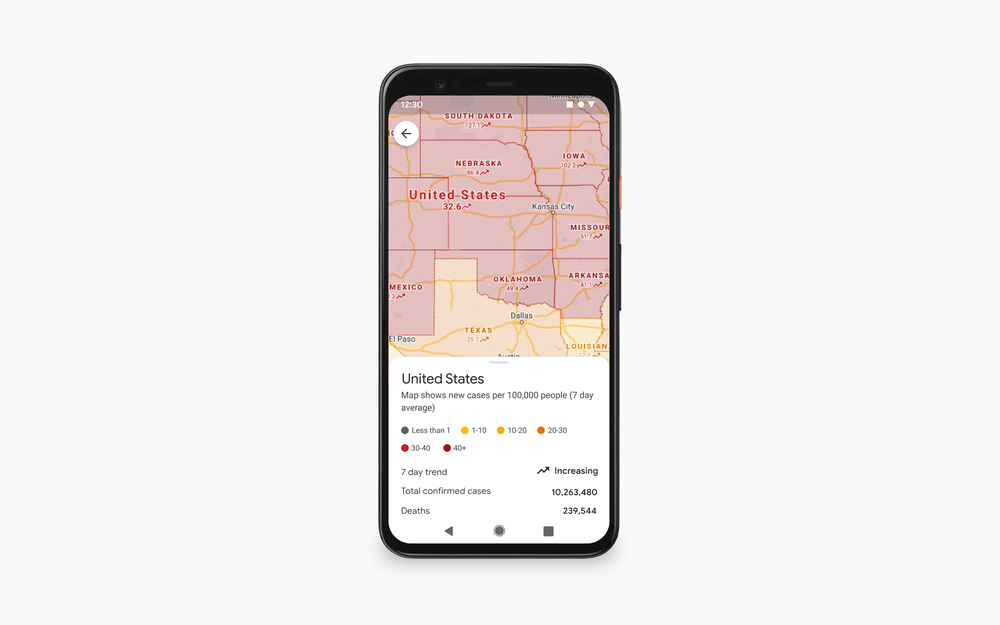
Now you can see all-time detected COVID-19 cases in an area and links to local, authoritative resources right from the COVID layer.
Avoiding holiday crowds might have always been your thing, but this year, we’re making it especially easy for everyone. If you need to take transit, Google Maps can help you more easily social distance with live crowdedness information. On Android and iOS globally, you’ll start seeing how crowded your bus, train, or subway line is right now based on real-time feedback from Google Maps users around the world (wherever data is available).
See how crowded your transit line is right now.
The right information, at just the right time
You may be in the mood to cook an elaborate holiday meal—or you may not. If you fall into the latter category, we’re rolling out the ability to see the live status of takeout and delivery orders in the United States, Canada, Germany, Australia, Brazil and India when you book or order from Google Maps on Android and iOS. Now, you can know when to pick up your food, or when you can expect it to arrive at your doorstep. You can also see expected wait times and delivery fees, and easily reorder your favorites right from the Google Maps app. And when it’s safe to head to restaurants, you’ll soon be able to quickly see the status of your reservation in 70 countries around the world.
Now you can see the live status of your takeout or delivery order.
Get more done
Even without a global pandemic, the holidays are busy and you may need to spend some time on the road. Last year, we shared an early look at Google Assistant driving mode in Maps, and today, we're starting to roll out an early preview of the improved experience to Android users in English in the U.S.—with more features coming soon.
Thanks to the new driving-friendly Assistant interface, you can easily get more done while keeping your focus on the road. Use voice to send and receive calls and texts, quickly review new messages across your messaging apps in one place, and get a read-out of your texts so you don’t need to look down at your phone—Assistant will even alert you to an incoming call so you can answer or decline with voice. You can also play media from hundreds of providers around the globe, including YouTube Music, Spotify, Google Podcasts and many more. Driving mode makes all of this possible without ever leaving the navigation screen, so you can minimize distractions on the road. To get started with driving mode, begin navigating to a destination with Google Maps and tap on the pop up to get started. Or, head to Assistant settings on your Android phone or say "Hey Google, open Assistant settings.” Then select “Getting around,” choose “Driving mode” and turn it on.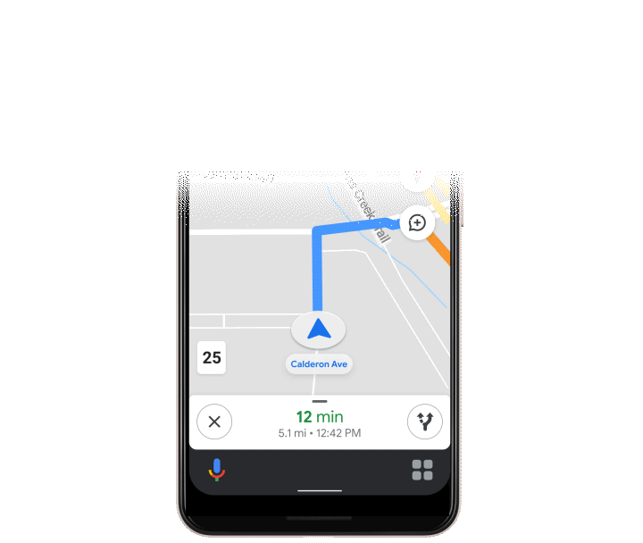
Assistant driving mode in Maps lets you get more done while keeping your focus on the road
While the ways we make life easier for you have changed, our commitment to do this has been there all along. Over the past 15 years, Google Maps has used technology to bring helpful information about the real world right to your fingertips. To make sure that information is as accurate and up-to-date as possible, we rely on 170 billion high-definition Street View images from 87 countries, contributions from hundreds of millions of businesses and people using Google Maps, and authoritative data from more than 10,000 local governments, transit agencies and organizations. We also invest in technical approaches that power some of our most beloved and essential features—from the 20 million places globally that now show popular times data to AR-powered Live View.
Even in a pandemic, more than 1 billion people still turn to Google Maps to navigate their new normal—and our work is far from done. We’re continually working to build new features and services to help all of us emerge from this challenging time stronger than ever. So whatever your plans are this holiday season and no matter how much they’ve changed, Google Maps can make them easier and safer for you.
Stay informed and get around safely with Google Maps
by Dane Glasgow on Oct.16, 2020, under 3D Models, Argentina, Australia, Brazil, California, Denmark, England, Germany, Google Earth News, Google Earth Tips, Google Sky, Google maps, Hawaii, Indonesia, Ireland, Italy, Japan, Kenya, Mexico, Natural Landmarks, Netherlands, Sightseeing, Street Views, USA
People turn to Google Maps for accurate, fresh information about what’s going on in the world—especially so during the pandemic. Activities like picking up something from the store, going for a walk, or grabbing a bite to eat now require a significant amount of planning and preparation. At any given time, you may be thinking: “Does the place I’m headed to have enough room for social distancing?” or “What safety precautions are being taken at my destination?”
Today, as part of our Search On event, we’re announcing new improvements to arm you with the information you need to navigate your world safely and get things done.
Make informed decisions with new live busyness updates
The ability to see busyness information on Google Maps has been one of our most popular features since it launched back in 2016. During the pandemic, this information has transformed into an essential tool, helping people quickly understand how busy a place is expected to be so they can make better decisions about where to go and when. In fact, as people around the world adjusted to life during the pandemic, they used popular times and live busyness information more. We saw engagement with these features rise 50 percent between March and May as more people tapped, scrolled and compared data to find the best days and times to go places.
We’ve been expanding live busyness information to millions of places around the world, and are on track to increase global coverage by five times compared to June 2020. This expansion includes more outdoor areas, like beaches and parks, and essential places, like grocery stores, gas stations, laundromats and pharmacies. Busyness information will surface in directions and right on the map—so you don’t even need to search for a specific place in order to see how busy it is. This will soon be available to Android, iOS and desktop users worldwide.
You’ll soon be able to see live busyness information without even searching for a place.

See live busyness information for your destination when getting directions
A new way to source up-to-date business information
It’s hard to know how a business’ offerings have changed during the pandemic. To help people find the freshest business information possible, we’ve been using Duplex conversational technology to call businesses and verify their information on Maps and Search. Since April 2020, this information has helped make more than 3 million updates, including updated hours of operation, delivery and pickup options, and store inventory information for in-demand products such as face masks, hand sanitizer and disinfectant. To date, these updates have been viewed more than 20 billion times.
Important health and safety information about businesses is now front and center on Maps and Search. You can quickly know what safety precautions a business is taking, such as if they require customers to wear masks and make reservations, if there’s plexiglass onsite, or if their staff takes regular temperature checks. This information comes directly from businesses, and soon Google Maps users will also be able to contribute this useful information.
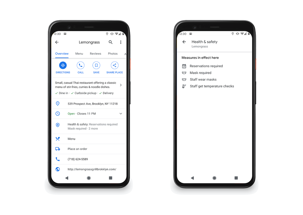
Health and safety information is now front and center in Google Maps
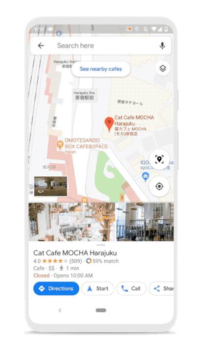
See helpful information right from Live View
Getting around your city looks different these days. The stakes are higher due to safety concerns, and it’s important to have all the information you need before deciding to visit a place. In the coming months, people using Android and iOS devices globally will be able to use Live View, a feature that uses AR to help you find your way, to learn more about a restaurant, store or business.
Say you’re walking around a new neighborhood, and one boutique in particular captures your attention. You’ll be able to use Live View to quickly learn if it’s open, how busy it is, its star rating, and health and safety information if available,
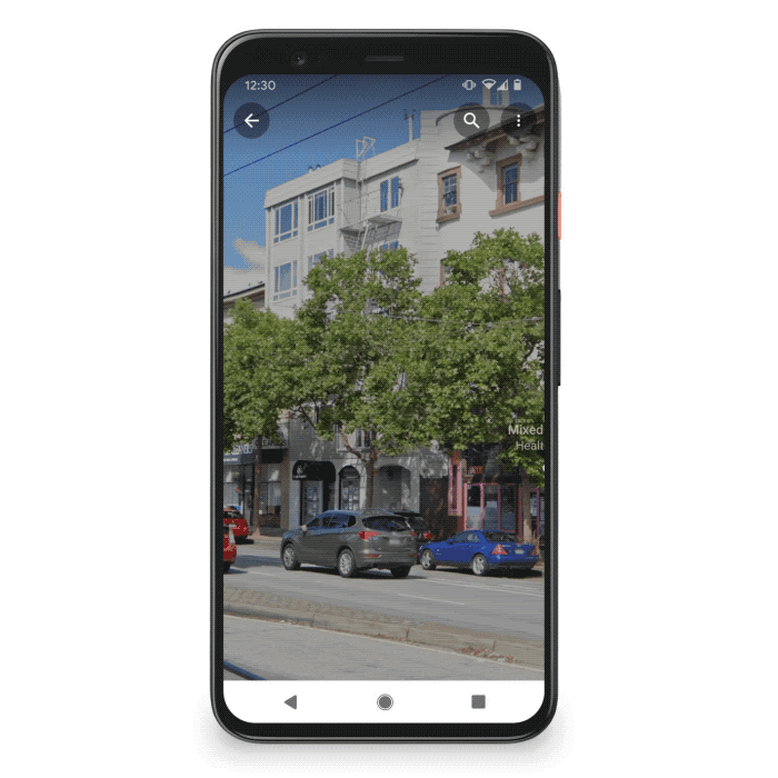
Use Live View to quickly see helpful information about a business.
The pandemic has changed how we interact with the world. Getting around, shopping for essentials and finding things to do all require more thought and consideration, and Google Maps is here to help.
Google Maps is turning 15! Celebrate with a new look and features
by Dane Glasgow on Feb.06, 2020, under 3D Models, Argentina, Australia, Brazil, California, Denmark, England, Germany, Google Earth News, Google Earth Tips, Google Sky, Google maps, Hawaii, Indonesia, Ireland, Italy, Japan, Kenya, Mexico, Natural Landmarks, Netherlands, Sightseeing, Street Views, USA
In 2005, we set out to map the world. Since then we’ve pushed the limits of what a map can do: from helping you easily navigate from point A to B, to helping you explore and get things done in the world. With more than 1 billion people turning to Google Maps to see and explore the world, we're celebrating our 15th birthday with a new look and product updates based on feedback from you.
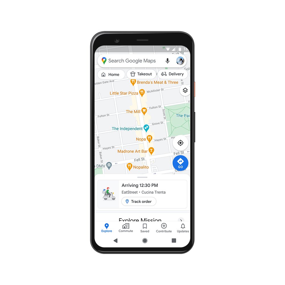
A fresh look from the inside out
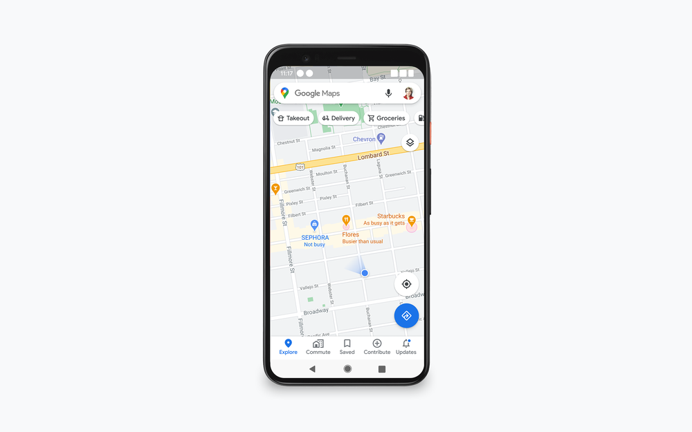
Starting today, you'll see an updated Google Maps app for Android and iOS that gives you everything you need at your fingertips with five easy-to-access tabs: Explore, Commute, Saved, Contribute and Updates.
Explore: Looking for a place nearby to grab lunch, enjoy live music or play arcade games? In the Explore tab, you’ll find information, ratings, reviews and more for about 200 million places around the world, including local restaurants, nearby attractions and city landmarks.
Commute: Whether you’re traveling by car or public transit, the Commute tab is there to make sure you’re on the most efficient route. Set up your daily commute to get real-time traffic updates, travel times and suggestions for alternative routes.
Saved: People have saved more than 6.5 billion places on Google Maps—from the new bakery across town to the famous restaurant on your upcoming vacation. Now you can view all of these spots in one convenient place, as well as find and organize plans for an upcoming trip and share recommendations based on places you've been.
Contribute: Hundreds of millions of people each year contribute information that helps keep Google Maps up to date. With the new Contribute tab, you can easily share local knowledge, such as details about roads and addresses, missing places, business reviews and photos. Each contribution goes a long way in helping others learn about new places and decide what to do.
Updates: The new Updates tab provides you with a feed of trending, must-see spots from local experts and publishers, like The Infatuation. In addition to discovering, saving and sharing recommendations with your network, you can also directly chat with businesses to get questions answered.
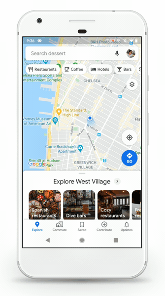
Our five tabs provide easier access to everything you need in Google Maps.
We’re also updating our look with a new Google Maps icon that reflects the evolution we’ve made mapping the world. It’s based on a key part of Google Maps since the very beginning—the pin— and represents the shift we’ve made from getting you to your destination to also helping you discover new places and experiences.
And because we can’t resist a good birthday celebration, keep an eye out for our celebratory party-themed car icon, available for a limited time when you navigate with Google Maps.
Made for you, on the go
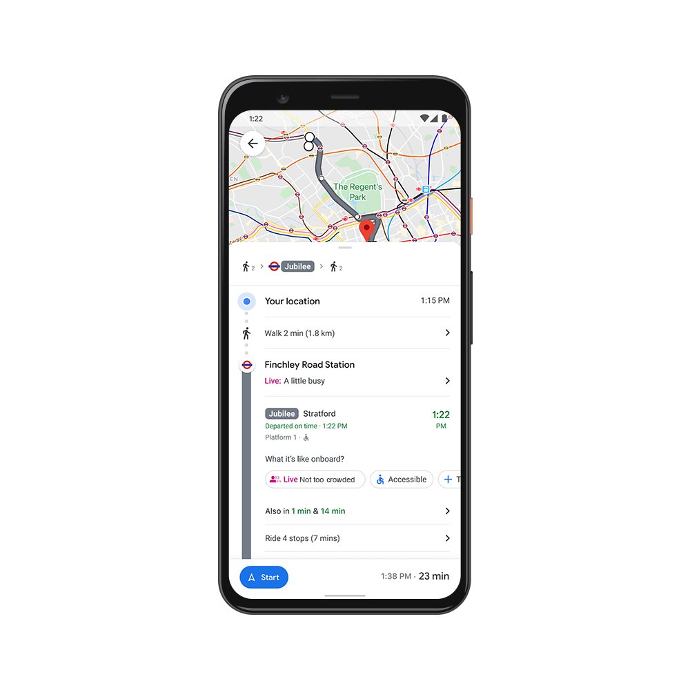
We’re constantly evolving to help you get around—no matter how you choose to travel. Our new transit features in the Google Maps app help you stay informed when you’re taking public transportation.
Last year, we introduced crowdedness predictions to help you see how crowded your bus, train or subway is likely to be based on past rides. To help you plan your travels, we’re adding new insights about your route from past riders, so you’ll be able to see important details, such as:
- Temperature: For a more comfortable ride, check in advance if the temperature is considered by past riders as on the colder or warmer side.
- Accessibility: If you have special needs or require additional support, you can identify public transit lines with staffed assistance, accessible entrance and seating, accessible stop-button or hi-visible LED.
- Women’s Section: In regions where transit systems have designated women's sections or carriages, we'll help surface this information along with whether other passengers abide by it.
- Security Onboard: Feel safer knowing if security monitoring is on board—whether that’s with a security guard present, installed security cameras or an available helpline.
- Number of carriages available: In Japan only, you can pick a route based on the number of carriages so that it increases your chances of getting a seat.
These useful bits of information come from past riders who've shared their experiences and will appear alongside public transit routes when available. To help future riders, you can answer a short survey within Google Maps about your experience on recent trips. We’ll start rolling this out globally in March, with availability varying by region and municipal transportation agency.
New trip attributes help you make informed decisions about your travel plans.
A sense of direction
Last year, we introduced Live View to help you quickly decide which way to go when you start a walking route with Google Maps. By combining Street View’s real-world imagery, machine learning and smartphone sensors, Live View in Google Maps shows you your surroundings with the directions overlaid in augmented reality.
Over the coming months, we’ll be expanding Live View and testing new capabilities, starting with better assistance whenever you’re searching for a place. You’ll be able to quickly see how far away and in which direction a place is.
Live View will soon help you get oriented in the right direction in new ways.
A big thank you to everyone for placing your trust in us and for being with us on this wild ride over the last 15 years. See you out there on the journey!
Google Maps is turning 15! Celebrate with a new look and features
by Dane Glasgow on Feb.06, 2020, under 3D Models, Argentina, Australia, Brazil, California, Denmark, England, Germany, Google Earth News, Google Earth Tips, Google Sky, Google maps, Hawaii, Indonesia, Ireland, Italy, Japan, Kenya, Mexico, Natural Landmarks, Netherlands, Sightseeing, Street Views, USA
In 2005, we set out to map the world. Since then we’ve pushed the limits of what a map can do: from helping you easily navigate from point A to B, to helping you explore and get things done in the world. With more than 1 billion people turning to Google Maps to see and explore the world, we're celebrating our 15th birthday with a new look and product updates based on feedback from you.
A fresh look from the inside out
Starting today, you'll see an updated Google Maps app for Android and iOS that gives you everything you need at your fingertips with five easy-to-access tabs: Explore, Commute, Saved, Contribute and Updates.
Explore: Looking for a place nearby to grab lunch, enjoy live music or play arcade games? In the Explore tab, you’ll find information, ratings, reviews and more for about 200 million places around the world, including local restaurants, nearby attractions and city landmarks.
Commute: Whether you’re traveling by car or public transit, the Commute tab is there to make sure you’re on the most efficient route. Set up your daily commute to get real-time traffic updates, travel times and suggestions for alternative routes.
Saved: People have saved more than 6.5 billion places on Google Maps—from the new bakery across town to the famous restaurant on your upcoming vacation. Now you can view all of these spots in one convenient place, as well as find and organize plans for an upcoming trip and share recommendations based on places you've been.
Contribute: Hundreds of millions of people each year contribute information that helps keep Google Maps up to date. With the new Contribute tab, you can easily share local knowledge, such as details about roads and addresses, missing places, business reviews and photos. Each contribution goes a long way in helping others learn about new places and decide what to do.
Updates: The new Updates tab provides you with a feed of trending, must-see spots from local experts and publishers, like The Infatuation. In addition to discovering, saving and sharing recommendations with your network, you can also directly chat with businesses to get questions answered.
Our five tabs provide easier access to everything you need in Google Maps.
We’re also updating our look with a new Google Maps icon that reflects the evolution we’ve made mapping the world. It’s based on a key part of Google Maps since the very beginning—the pin— and represents the shift we’ve made from getting you to your destination to also helping you discover new places and experiences.
And because we can’t resist a good birthday celebration, keep an eye out for our celebratory party-themed car icon, available for a limited time when you navigate with Google Maps.
Made for you, on the go
We’re constantly evolving to help you get around—no matter how you choose to travel. Our new transit features in the Google Maps app help you stay informed when you’re taking public transportation.
Last year, we introduced crowdedness predictions to help you see how crowded your bus, train or subway is likely to be based on past rides. To help you plan your travels, we’re adding new insights about your route from past riders, so you’ll be able to see important details, such as:
- Temperature: For a more comfortable ride, check in advance if the temperature is considered by past riders as on the colder or warmer side.
- Accessibility: If you have special needs or require additional support, you can identify public transit lines with staffed assistance, accessible entrance and seating, accessible stop-button or hi-visible LED.
- Women’s Section: In regions where transit systems have designated women's sections or carriages, we'll help surface this information along with whether other passengers abide by it.
- Security Onboard: Feel safer knowing if security monitoring is on board—whether that’s with a security guard present, installed security cameras or an available helpline.
- Number of carriages available: In Japan only, you can pick a route based on the number of carriages so that it increases your chances of getting a seat.
These useful bits of information come from past riders who've shared their experiences and will appear alongside public transit routes when available. To help future riders, you can answer a short survey within Google Maps about your experience on recent trips. We’ll start rolling this out globally in March, with availability varying by region and municipal transportation agency.
New trip attributes help you make informed decisions about your travel plans.
A sense of direction
Last year, we introduced Live View to help you quickly decide which way to go when you start a walking route with Google Maps. By combining Street View’s real-world imagery, machine learning and smartphone sensors, Live View in Google Maps shows you your surroundings with the directions overlaid in augmented reality.
Over the coming months, we’ll be expanding Live View and testing new capabilities, starting with better assistance whenever you’re searching for a place. You’ll be able to quickly see how far away and in which direction a place is.
Live View will soon help you get oriented in the right direction in new ways.
A big thank you to everyone for placing your trust in us and for being with us on this wild ride over the last 15 years. See you out there on the journey!