Tag: covid-19
How we’re helping get vaccines to more people
by Sundar Pichai on Jan.25, 2021, under 3D Models, Argentina, Australia, Brazil, California, Denmark, England, Germany, Google Earth News, Google Earth Tips, Google Sky, Google maps, Hawaii, Indonesia, Ireland, Italy, Japan, Kenya, Mexico, Natural Landmarks, Netherlands, Sightseeing, Street Views, USA
The pandemic has taken a devastating toll on communities worldwide. While there is much uncertainty still ahead, the development of multiple safe vaccines in such a short time gives us reason for hope. Now the work begins to ensure that everyone can benefit from this triumph of scientific achievement, and quickly.
During the pandemic, Google has helped people get the information they need to keep their families safe and healthy. We’ve supported small businesses and partnered with Apple to build exposure notification technology to fight the spread of COVID-19 around the world. Now, as public health authorities ramp up vaccination efforts, we’re finding more ways to help.
We recognize that getting vaccines to people is a complex problem to solve, and we’re committed to doing our part. Today we’re announcing that we’re providing more than $150 million to promote vaccine education and equitable distribution and making it easier to find locally relevant information, including when and where to get the vaccine. We’ll also be opening up Google spaces to serve as vaccination sites as needed.
$150 million to promote vaccine education and equitable access
Since the beginning of the pandemic, we’ve helped more than 100 government agencies and global non-governmental organizations run critical public service health announcements through our Ad Grants Crisis Relief program. Today, we’re announcing an additional $100 million in ad grants for the CDC Foundation, the World Health Organization, and nonprofits around the globe. We’ll invest another $50 million in partnership with public health agencies to reach underserved communities with vaccine-related content and information.
Our efforts will focus heavily on equitable access to vaccines. Early data in the U.S. shows that disproportionately affected populations, especially people of color and those in rural communities, aren’t getting access to the vaccine at the same rates as other groups. To help, Google.org has committed $5 million in grants to organizations addressing racial and geographic disparities in COVID-19 vaccinations, including Morehouse School of Medicine’sSatcher Health Leadership Institute and the CDC Foundation.
Highlighting authoritative information and local vaccination sites on Search & Maps
To help find accurate and timely information on vaccines, we’ve expanded our information panels on Search to more than 40 countries and dozens of languages, with more rolling out in the coming week. We’ll begin showing state and regional distribution information on Search so people can easily find when they are eligible to receive a vaccine. Soon we’ll launch a “Get The Facts'' initiative across Google and YouTube to get authoritative information out to the public about vaccines.
Searches for “vaccines near me” have increased 5x since the beginning of the year and we want to make sure we’re providing locally relevant answers. In the coming weeks, COVID-19 vaccination locations will be available in Google Search and Maps, starting with Arizona, Louisiana, Mississippi and Texas, with more states and countries to come. We’ll include details like whether an appointment or referral is required, if access is limited to specific groups, or if it has a drive-through. We’re working with partners like VaccineFinder.org, an initiative of Boston Children's Hospital, and other authoritative sources, such as government agencies and retail pharmacies, to gather vaccination location information and make it available.
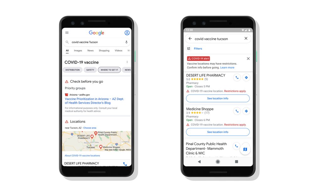
Search and Maps will soon show vaccination sites with important details
Opening our spaces for vaccination clinics
To help with vaccination efforts, starting in the United States, we’ll make select Google facilities—such as buildings, parking lots and open spaces—available as needed. These sites will be open to anyone eligible for the vaccine based on state and local guidelines. We’ll start by partnering with health care provider One Medicaland public health authorities to open sites in Los Angeles and the San Francisco Bay Area in California; Kirkland, Washington; and New York City, with plans to expand nationally. We’re working with local officials to determine when sites can open based on local vaccine availability.
Using our technology to improve vaccine distribution
Google Cloud is helping healthcare organizations, retail pharmacies, logistics companies, and public sector institutions make use of innovative technologies to speed up delivery of vaccines. For example, logistics companies are using our AI to optimize trucking operations by adapting to traffic or inclement weather, and detect temperature fluctuations during transport. Once vaccines reach their destination, our tools help facilitate pre-screening, scheduling, and follow up. And our Intelligent Vaccine Impact Platform is helping states like New York and North Carolina manage distribution and forecast where vaccines, personal protective equipment, and hospital staffing will be most needed.
The COVID-19 pandemic has deeply affected every community all over the world. It’s also inspired coordination between public and private sectors, and across international borders, on a remarkable scale. We can’t slow down now. Getting vaccines to billions of people won’t be easy, but it’s one of the most important problems we’ll solve in our lifetimes. Google will continue to support in whatever way we can.
Google Maps updates to get you through the holidays
by Dane Glasgow on Nov.17, 2020, under 3D Models, Argentina, Australia, Brazil, California, Denmark, England, Germany, Google Earth News, Google Earth Tips, Google Sky, Google maps, Hawaii, Indonesia, Ireland, Italy, Japan, Kenya, Mexico, Natural Landmarks, Netherlands, Sightseeing, Street Views, USA
This year, we’ve made it easier to find information that helps you stay safe, up-to-date, and connected. Since the start of the pandemic, we’ve added nearly 250 new features and improvements to Google Maps to help you adapt to this new normal—from live busyness information for millions of places, to the ability to easily see critical health and safety information at a glance. And we’re continuing to invest in ways to keep information in Maps fresh, with over 50 million updates made to the map each day. Even as the holidays approach, we don’t plan on slowing down. If you need to be out and about this holiday season, here are four ways that Google Maps can help you get around safely and get things done.
Get around
Whether you’re heading out of town or staying local, keeping a pulse on the latest COVID trends can help you stay safe. Since we launched the COVID layer, it’s helped nearly 10 million people get critical information about COVID-19 right from Google Maps.
We’re rolling out two new improvements in the coming weeks. The updated COVID layer on Android and iOS will soon show more information, including all-time detected cases in an area, along with quick links to COVID resources from local authorities. This is especially handy if you’re heading out of town and need to get up to speed about the local guidelines, testing sites and restrictions in another city.
Now you can see all-time detected COVID-19 cases in an area and links to local, authoritative resources right from the COVID layer.
Avoiding holiday crowds might have always been your thing, but this year, we’re making it especially easy for everyone. If you need to take transit, Google Maps can help you more easily social distance with live crowdedness information. On Android and iOS globally, you’ll start seeing how crowded your bus, train, or subway line is right now based on real-time feedback from Google Maps users around the world (wherever data is available).
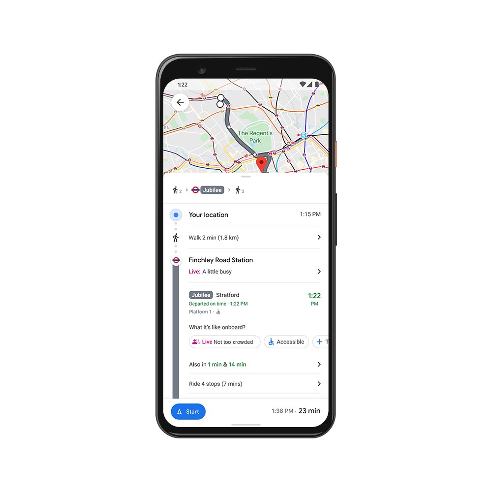
See how crowded your transit line is right now.
The right information, at just the right time
You may be in the mood to cook an elaborate holiday meal—or you may not. If you fall into the latter category, we’re rolling out the ability to see the live status of takeout and delivery orders in the United States, Canada, Germany, Australia, Brazil and India when you book or order from Google Maps on Android and iOS. Now, you can know when to pick up your food, or when you can expect it to arrive at your doorstep. You can also see expected wait times and delivery fees, and easily reorder your favorites right from the Google Maps app. And when it’s safe to head to restaurants, you’ll soon be able to quickly see the status of your reservation in 70 countries around the world.
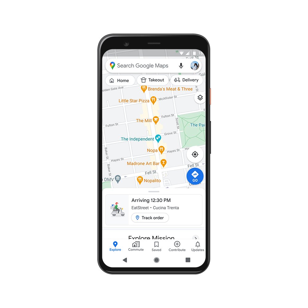
Now you can see the live status of your takeout or delivery order.
Get more done
Even without a global pandemic, the holidays are busy and you may need to spend some time on the road. Last year, we shared an early look at Google Assistant driving mode in Maps, and today, we're starting to roll out an early preview of the improved experience to Android users in English in the U.S.—with more features coming soon.
Thanks to the new driving-friendly Assistant interface, you can easily get more done while keeping your focus on the road. Use voice to send and receive calls and texts, quickly review new messages across your messaging apps in one place, and get a read-out of your texts so you don’t need to look down at your phone—Assistant will even alert you to an incoming call so you can answer or decline with voice. You can also play media from hundreds of providers around the globe, including YouTube Music, Spotify, Google Podcasts and many more. Driving mode makes all of this possible without ever leaving the navigation screen, so you can minimize distractions on the road. To get started with driving mode, begin navigating to a destination with Google Maps and tap on the pop up to get started. Or, head to Assistant settings on your Android phone or say "Hey Google, open Assistant settings.” Then select “Getting around,” choose “Driving mode” and turn it on.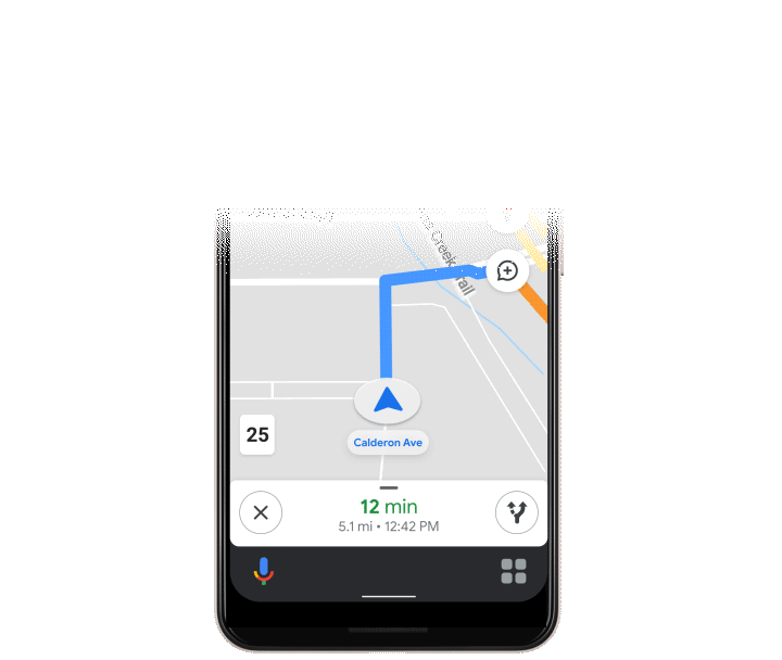
Assistant driving mode in Maps lets you get more done while keeping your focus on the road
While the ways we make life easier for you have changed, our commitment to do this has been there all along. Over the past 15 years, Google Maps has used technology to bring helpful information about the real world right to your fingertips. To make sure that information is as accurate and up-to-date as possible, we rely on 170 billion high-definition Street View images from 87 countries, contributions from hundreds of millions of businesses and people using Google Maps, and authoritative data from more than 10,000 local governments, transit agencies and organizations. We also invest in technical approaches that power some of our most beloved and essential features—from the 20 million places globally that now show popular times data to AR-powered Live View.
Even in a pandemic, more than 1 billion people still turn to Google Maps to navigate their new normal—and our work is far from done. We’re continually working to build new features and services to help all of us emerge from this challenging time stronger than ever. So whatever your plans are this holiday season and no matter how much they’ve changed, Google Maps can make them easier and safer for you.
Br(rr)ing on the holiday trends from Google Maps
by Holly Day on Nov.17, 2020, under 3D Models, Argentina, Australia, Brazil, California, Denmark, England, Germany, Google Earth News, Google Earth Tips, Google Sky, Google maps, Hawaii, Indonesia, Ireland, Italy, Japan, Kenya, Mexico, Natural Landmarks, Netherlands, Sightseeing, Street Views, USA
This holiday, family gatherings will be smaller or take place virtually to make sure everyone stays safe and healthy. Indoor activities will move outdoors. And that international holiday vacation will potentially transform into an epic road trip to nearby attractions as you stop to sightsee at local hidden gems along the way. But even still, people are prepping to make classic holiday dishes, looking for ways to experience winter and finding new, safe ways to be together.
We’ve analyzed Google Maps data before and during the pandemic (for the purposes of this post, we analyzed data from March to October 2020) to see how people across the U.S. are getting ready for the holidays. Read on for top trends on how people are navigating, how they’re spending their time and what type of food they’re craving.
Google Maps: Your holiday sidekick
by Holly Day on Nov.17, 2020, under 3D Models, Argentina, Australia, Brazil, California, Denmark, England, Germany, Google Earth News, Google Earth Tips, Google Sky, Google maps, Hawaii, Indonesia, Ireland, Italy, Japan, Kenya, Mexico, Natural Landmarks, Netherlands, Sightseeing, Street Views, USA
The holiday season is starting—which means time with friends, family, and lots of food. And though festivities may be a bit different this year, there are still creative, safe ways to celebrate and stay connected. No matter what you have in store for the holidays, these Google Maps tips can help you stay informed, stay connected and save time.
Stay informed even while running holiday errands and traveling
1. Check out how busy a place is:Popular times and live busyness information can tell you how crowded a place typically is on a given day or time—and even how busy it is right now. This is especially handy during the era of social distancing: Check out busyness on Maps before you head to a restaurant, store, business, or place to avoid holiday crowds and long waits.2. (New!) Find the latest information about COVID-19: If you’re thinking about heading out of town to another city or state, you can use the COVID layer on Maps to quickly see how cases are trending in the area. You can also access quick links to authoritative local resources so you know at a glance if there are specific guidelines or restrictions in the area you’re visiting.
3. Quickly understand safety precautions from a business: If you're eating out or getting a head start on your holiday shopping, you can easily learn more about what safety precautions a business is taking. Find out if they’re sanitizing between customers, if there's safety dividers at checkout and if they require staff to have regular temperature checks.
If you need to, connect safely
4. Share your ETA:If you need to see loved ones, let them know when they can expect you to arrive with you just a few taps.5. Don’t get lost: Planning to meet up with friends outdoors and at a distance? When a friend has chosen to share their location with you, you can easily tap on their icon and then on Live View to see where and how far away they are—with overlaid arrows and directions that help you know where to go.
Save time so you can spend more time enjoying the festivities
6. (New!) Get more done on drives:If you’re road tripping home, using voice with Google Assistant driving mode in Maps helps make the ride more convenient and enjoyable while keeping your focus on the road. Starting to roll out today as a preview, Android users in the U.S. can now get call alerts from Assistant, answer or decline calls by simply using their voice, quickly review incoming messages across apps in one place, and play podcasts and songs from hundreds of media providers—all without leaving the navigation screen.7. (New!) Don’t let your food get cold: If you’re taking a low-key approach to the holidays this year and opting to order in instead of cooking an elaborate meal, Google Maps can help. When searching on your phone for restaurants nearby, you can easily sort by places that offer takeout or delivery and place your order directly from Google Maps. Now you can also see exactly when your order will be delivered or ready to pick up on the app’s home screen—because nobody likes cold turkey!
8. Search along your route: If you’re on the road and realize you need to make a stop—say you’re running low on gas or need to pick up a last-minute item from the market—use Google Maps to search for gas stations, grocery stores, or other places along your drive so you can tackle your tasks without going too far out of your way.
Tips for holiday travel and beyond
by Richard Holden on Nov.10, 2020, under 3D Models, Argentina, Australia, Brazil, California, Denmark, England, Germany, Google Earth News, Google Earth Tips, Google Sky, Google maps, Hawaii, Indonesia, Ireland, Italy, Japan, Kenya, Mexico, Natural Landmarks, Netherlands, Sightseeing, Street Views, USA
While many people will celebrate the holidays at home this year, 40 percent of Americans are still planning to travel. Here are a few ways Google can help you make informed travel decisions or revisit trips from holidays past.
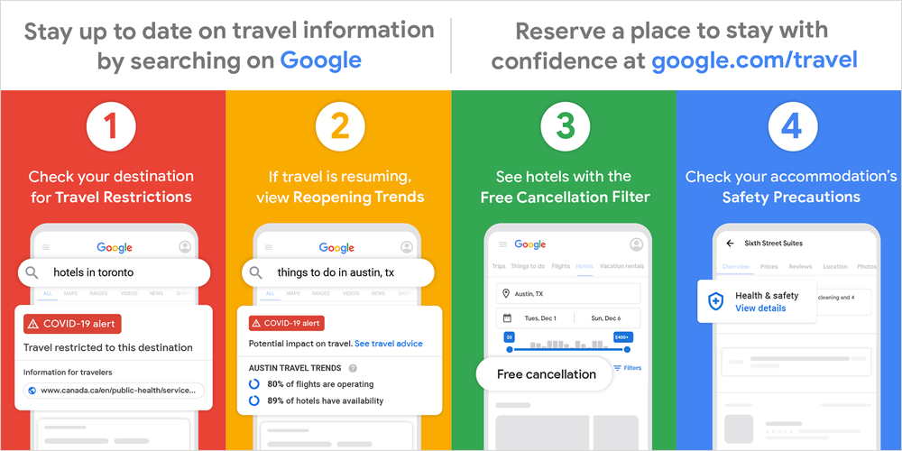
Stay up to date on the latest travel information
When you search on Google for information about hotels, flights or things to do, check to see if there’s a COVID-19 travel advisory or restriction for your destination. If there are no restrictions, you can see indicators for travel reopening, like the percentage of flights operating or hotels with availability, directly in your Search results. On google.com/travel you can also see trends for flight and hotel availability over the past six months, as well as links to local resources, like the number of COVID-19 cases in the area.
Book accommodation confidently
Earlier this year we added a hotel “Free cancellation” filter on Search and google.com/travel to help you easily find properties with a refundable rate. In addition to refundable rates, many hotels and vacation rentals are taking additional measures to ensure the safety of guests in response to COVID-19. Now when you search for a place to stay on google.com/travel and view a specific property, you may see a tip when additional health and safety precautions, like enhanced cleaning, are being taken. Tap on the “About” tab to see the full list.
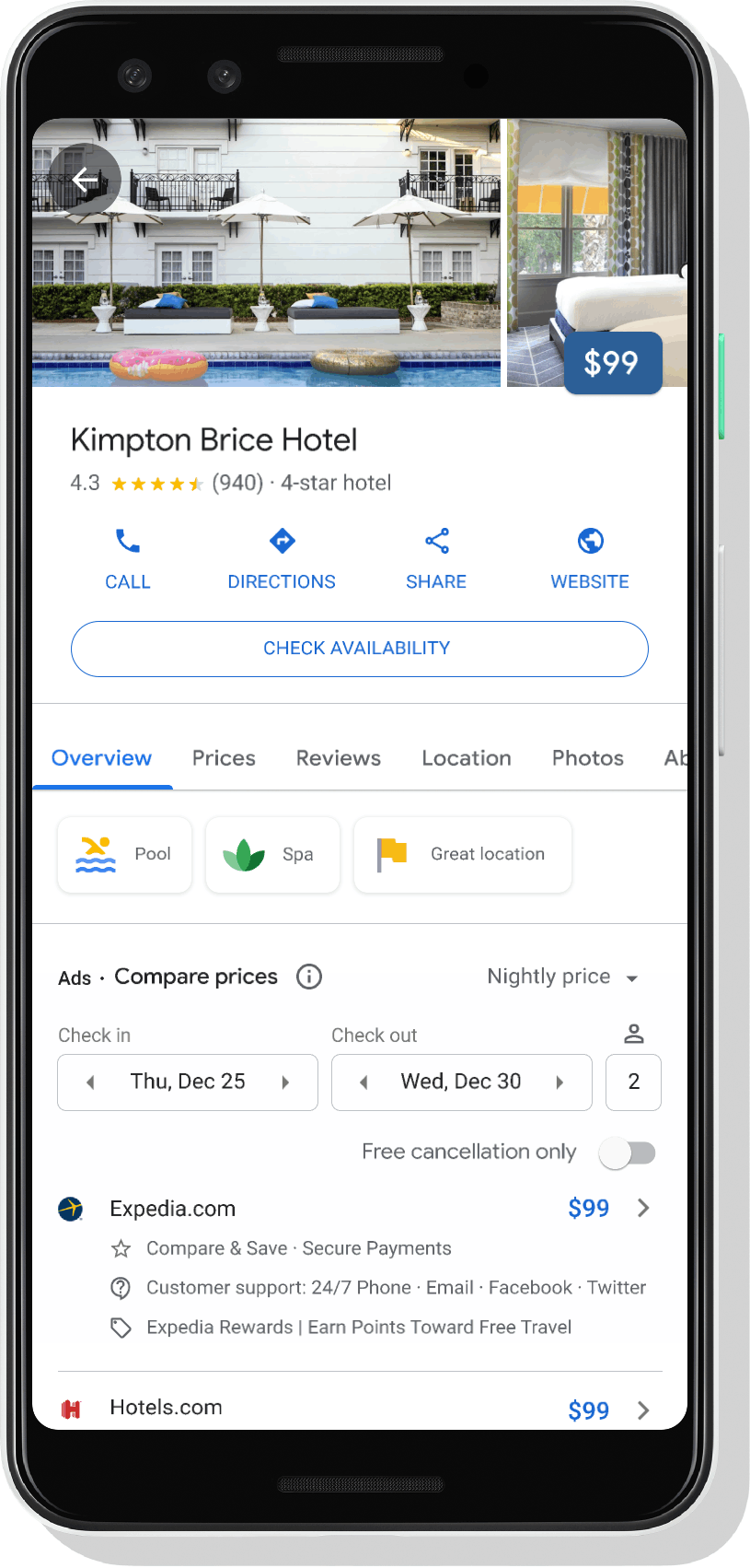
We’re working with hotels and vacation rental providers, as well as industry associations, to add more health and safety information to the results you see. If you’re a hotel owner, verify your business using Google My Business, and let guests know what measures you’re taking to keep them safe by adding health and safety attributes to your Business Profile.
See local COVID-19 information
If you’re planning to visit a new city, you can use the COVID layer in Google Maps to quickly get information about COVID-19 cases in the area—so you can make more informed decisions about where to go and what to do.
Stay informed on the road
Once you’re headed out on your trip, you can use Google Maps to see helpful safety alerts along the way. If you’re driving, we’ll notify you about COVID-19 checkpoints and restrictions along your route, like when crossing national borders. If you plan to take public transportation, we’ll show you alerts from local transit agencies, so you can quickly know if government mandates impact transit services or require you to wear a mask while riding the bus, subway, or train.
Get nostalgic & relive past trips
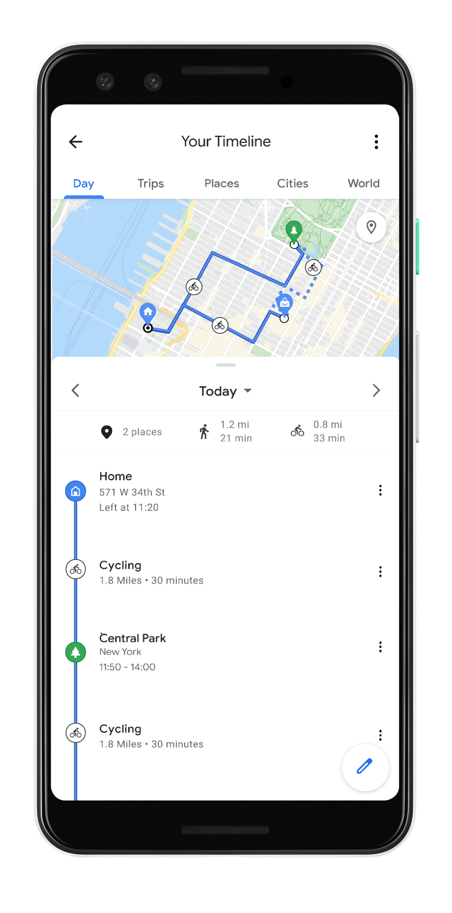
For those not traveling this holiday season, you can use new features in Google Maps or Google Photos to take a walk down memory lane. If you’re using Maps on Android, you can soon access the new “Trips” tab in Timeline to see a summary of your past vacations, along with information about the places you visited, the total kilometers traveled, and the modes of transportation you used. If you choose to turn on your Location History setting, you can use Trips in Timeline as a handy tool if you’re feeling nostalgic or want to share vacation recommendations with friends or family.
You can also see and share your past trip itineraries including hotels, restaurants and other places you’ve received reservation confirmations for in your Gmail by going togoogle.com/travel and tapping on the “Trips” tab.
In Google Photos, you can already see photos grouped by location with theinteractive map view. In the coming weeks, we’re bringing Timeline to the Photos map view, so you can easily see the paths you took on a certain day alongside your photos—whether you captured that epic shot while hiking through Yellowstone, or while driving down the scenic Pacific Coast Highway. You can choose to show or hide your Timeline from your map view's settings in Photos at any time.
If you will be traveling over the holidays, here’s a handy checklist to help you make informed decisions as you plan.
An update on our efforts to help Americans navigate COVID-19
by Ruth Porat on Oct.27, 2020, under 3D Models, Argentina, Australia, Brazil, California, Denmark, England, Germany, Google Earth News, Google Earth Tips, Google Sky, Google maps, Hawaii, Indonesia, Ireland, Italy, Japan, Kenya, Mexico, Natural Landmarks, Netherlands, Sightseeing, Street Views, USA
The COVID-19 pandemic has brought unprecedented challenges and emphasized how important it is for each of us to do our part to help find solutions. I’m sharing an update here on how Google is contributing to keep people safe and helping to get American businesses back up and running.
Contributing to economic recovery efforts
As I’ve written earlier, to help small businesses gain easier access to badly-needed capital, we founded the $170 million Grow with Google Small Business Fund alongside $10 million in Google.org grants, with an aim to help the most underserved small businesses, particularly those owned by women and minorities. In collaboration with Opportunity Finance Network, more than $53 million dollars of loans and Google.org grants have been allocated to community partners who are focused on serving rural, women, Black, Latino and Native borrowers, which helps American communities start to get back on their feet. Tires by Papi and Bailiwick Clothing Company are two such examples.
Of course, our greatest contribution continues to be developing products to help people stay informed, adapt and get through this pandemic.
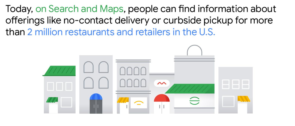
According to the Connected Commerce Council, nearly one in three small business owners report that without digital tools they would close all or parts of their business. To help small businesses, we rolled out many new, free product features earlier this year, so that they can inform their customers about things like takeout, delivery, no-contact delivery, or curbside pickup. Today, people can now find this information on Search and Maps for more than 2 million restaurants and retailers in the U.S.
We’ve used Google’s Duplex technology to make calls to businesses and confirm things like temporary closures. This has enabled us to make 3 million updates to business information globally, which have been seen by people over 20 billion times in Search and Maps.
To help people searching for jobs, we have stepped up to help in many ways. We added new relevant features in the U.S. like showing jobs that can be done remotely. Google Cloud has partnered with different states to help jobseekers: we assisted Rhode Island’s Virtual Career Center, a new platform that connects thousands of jobseekers with jobs and employment services; worked with the State of Illinois to develop a 24/7 Virtual Intelligent Agent on the IDES website; developed a chatbot, in partnership with the New Jersey Office of Innovation to provide real-time answers to the 20 most popular unemployment questions. These are just some of the examples.
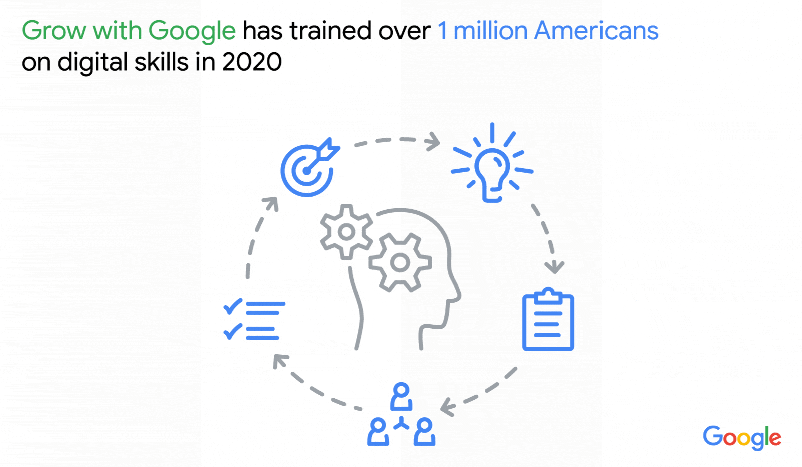
We also transformed our free Grow with Google training to virtual formats and have already trained more than 1 million Americans on digital skills this year. The Google IT Support Professional Certificate—which takes beginner learners to entry-level jobs ready in under six months—has become the most popular certificate on Coursera during COVID-19.
Providing trusted information
Questions related to the pandemic are more searched than sports or music (and even elections) in every state.
Top coronavirus related searches in the U.S. this month:
Coronavirus symptoms
Coronavirus update
Coronavirus vaccine
Across the U.S. people are searching on Google to stay informed and adapt. In 47 states, the top coronavirus-related question during the last six months has been “How many cases of coronavirus in [my state].” Search interest for “online courses” reached an all-time high in April this year, as did searches for “unemployment,”compared to search trends over the last 15 years.
During this time, we’ve also seen people seek out information to help them navigate their daily lives. For example, since the pandemic began, searches for “curbside pickup” have increased 13-fold compared to this time last year, while searches for “contact tracing” spiked 1,000 percent in April and then reached an all-time high in May.
In March, we launched Search Knowledge Panels so when people search for information related to COVID-19, they immediately see local guidance, information about symptoms, prevention and treatments. We’ve committed $250 million in Ad Grants to help government agencies provide critical information related to COVID-19. As of today we’ve served more than 100 million PSAs from local public health agencies, which have been seen by tens of millions of people across the U.S.
We also launched the Journalism Emergency Relief Fund to provide emergency funding for small and medium sized news organizations covering the pandemic. To date, we’ve distributed $9 million to U.S. newsrooms across all 50 states.
Helping people make safe choices
To help people make informed decisions about where to go, the COVID layer in Google Maps shows critical information about new cases in an area and how they’re trending. As of this month, our COVID-19 Community Mobility Reports, which are used by public health agencies and researchers around the globe, have been downloaded more than 16 million times.
In May, we partnered with Apple to launch the Exposure Notifications System (ENS) and made it available to public health authorities around the world in their fight against COVID-19. Designed specifically and carefully to protect users’ privacy while helping public health authorities and governments manage countries’ re-opening, today 13 states and U.S. territories have built apps based on this ENS technology.
In a short time, COVID-19 has changed how people live their lives. We’ll continue to update our products and roll out initiatives to help people and American businesses find trusted information, adapt and manage economic uncertainty.
Behind the scenes: popular times and live busyness information
by Matt D'Zmura on Oct.16, 2020, under 3D Models, Argentina, Australia, Brazil, California, Denmark, England, Germany, Google Earth News, Google Earth Tips, Google Sky, Google maps, Hawaii, Indonesia, Ireland, Italy, Japan, Kenya, Mexico, Natural Landmarks, Netherlands, Sightseeing, Street Views, USA
If you’ve ever been in a rush to grab a quick bite, you may know the pain that comes along with finding out that the restaurant you chose is packed and there’s nowhere to sit. Or maybe you need to pick up just one item from the grocery store, only to find that the line is out the door—derailing your plans and causing you unnecessary stress.
These problems were top of mind when Google Maps launched popular times and live busyness information—helpful features that let you see how busy a place tends to be on a given day and time or in a specific moment. This information has become a powerful tool during the pandemic, making it easier to social distance because you know in advance how crowded a place will be. Today, we’ll take a closer look at how we calculate busyness information, while keeping your data private and secure.
Popular times: making sense of historical busyness information
To calculate busyness insights, we analyze aggregated and anonymized Location History data from people who have opted to turn this setting on from their Google Account. This data is instrumental in calculating how busy a place typically is for every hour of the week. The busiest hour becomes our benchmark—and we then display busyness data for the rest of the week relative to that hour.
For example, say there’s a new ice cream shop down the block known for its homemade waffle cones
Stay informed and get around safely with Google Maps
by Dane Glasgow on Oct.16, 2020, under 3D Models, Argentina, Australia, Brazil, California, Denmark, England, Germany, Google Earth News, Google Earth Tips, Google Sky, Google maps, Hawaii, Indonesia, Ireland, Italy, Japan, Kenya, Mexico, Natural Landmarks, Netherlands, Sightseeing, Street Views, USA
People turn to Google Maps for accurate, fresh information about what’s going on in the world—especially so during the pandemic. Activities like picking up something from the store, going for a walk, or grabbing a bite to eat now require a significant amount of planning and preparation. At any given time, you may be thinking: “Does the place I’m headed to have enough room for social distancing?” or “What safety precautions are being taken at my destination?”
Today, as part of our Search On event, we’re announcing new improvements to arm you with the information you need to navigate your world safely and get things done.
Make informed decisions with new live busyness updates
The ability to see busyness information on Google Maps has been one of our most popular features since it launched back in 2016. During the pandemic, this information has transformed into an essential tool, helping people quickly understand how busy a place is expected to be so they can make better decisions about where to go and when. In fact, as people around the world adjusted to life during the pandemic, they used popular times and live busyness information more. We saw engagement with these features rise 50 percent between March and May as more people tapped, scrolled and compared data to find the best days and times to go places.
We’ve been expanding live busyness information to millions of places around the world, and are on track to increase global coverage by five times compared to June 2020. This expansion includes more outdoor areas, like beaches and parks, and essential places, like grocery stores, gas stations, laundromats and pharmacies. Busyness information will surface in directions and right on the map—so you don’t even need to search for a specific place in order to see how busy it is. This will soon be available to Android, iOS and desktop users worldwide.
You’ll soon be able to see live busyness information without even searching for a place.

See live busyness information for your destination when getting directions
A new way to source up-to-date business information
It’s hard to know how a business’ offerings have changed during the pandemic. To help people find the freshest business information possible, we’ve been using Duplex conversational technology to call businesses and verify their information on Maps and Search. Since April 2020, this information has helped make more than 3 million updates, including updated hours of operation, delivery and pickup options, and store inventory information for in-demand products such as face masks, hand sanitizer and disinfectant. To date, these updates have been viewed more than 20 billion times.
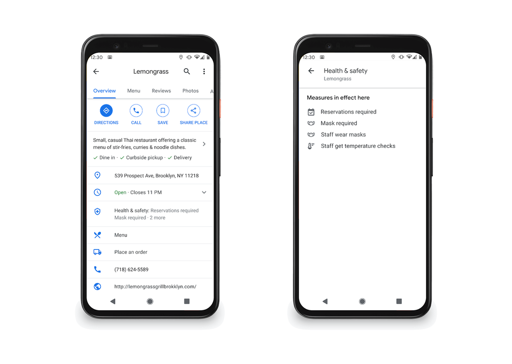
Important health and safety information about businesses is now front and center on Maps and Search. You can quickly know what safety precautions a business is taking, such as if they require customers to wear masks and make reservations, if there’s plexiglass onsite, or if their staff takes regular temperature checks. This information comes directly from businesses, and soon Google Maps users will also be able to contribute this useful information.
Health and safety information is now front and center in Google Maps
See helpful information right from Live View
Getting around your city looks different these days. The stakes are higher due to safety concerns, and it’s important to have all the information you need before deciding to visit a place. In the coming months, people using Android and iOS devices globally will be able to use Live View, a feature that uses AR to help you find your way, to learn more about a restaurant, store or business.
Say you’re walking around a new neighborhood, and one boutique in particular captures your attention. You’ll be able to use Live View to quickly learn if it’s open, how busy it is, its star rating, and health and safety information if available,
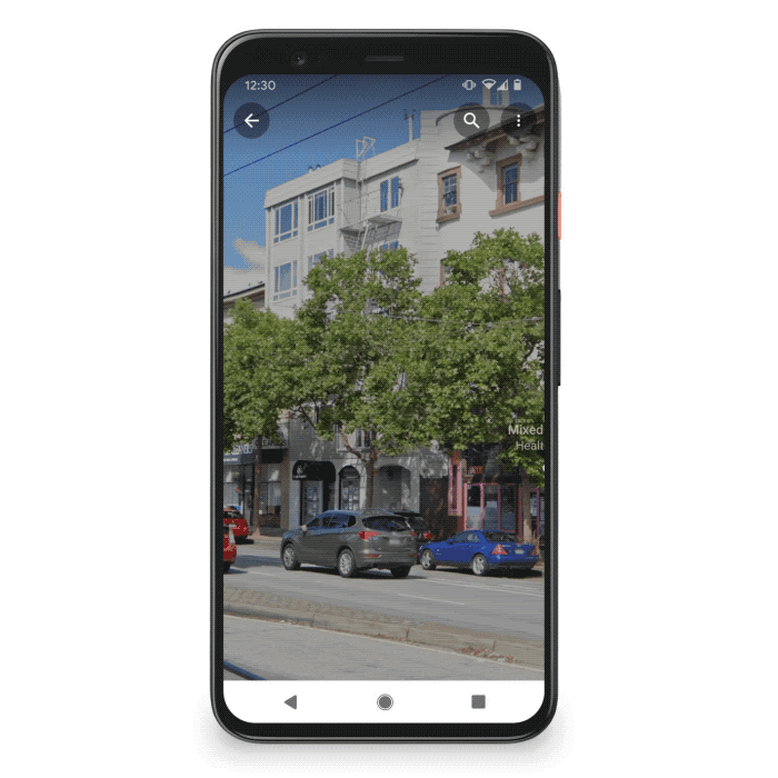
Use Live View to quickly see helpful information about a business.
The pandemic has changed how we interact with the world. Getting around, shopping for essentials and finding things to do all require more thought and consideration, and Google Maps is here to help.
Navigate safely with new COVID data in Google Maps
by Sujoy Banerjee on Sep.24, 2020, under 3D Models, Argentina, Australia, Brazil, California, Denmark, England, Germany, Google Earth News, Google Earth Tips, Google Sky, Google maps, Hawaii, Indonesia, Ireland, Italy, Japan, Kenya, Mexico, Natural Landmarks, Netherlands, Sightseeing, Street Views, USA
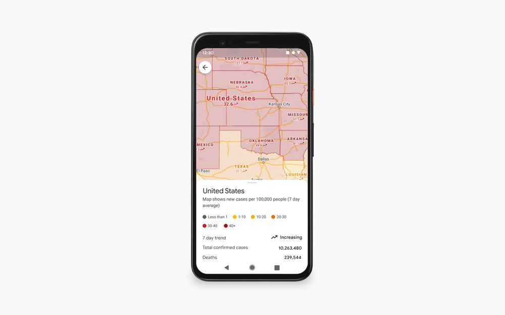
More than one billion people turn to Google Maps for essential information about how to get from place to place–especially during the pandemic when safety concerns are top of mind. Features like popular times and live busyness, COVID-19 alerts in transit, and COVID checkpoints in driving navigation were all designed to help you stay safe when you’re out and about. This week, we’re introducing the COVID layer in Maps, a tool that shows critical information about COVID-19 cases in an area so you can make more informed decisions about where to go and what to do.
How it works
When you open Google Maps, tap on the layers button on the top right hand corner of your screen and click on “COVID-19 info”. You’ll then see a seven-day average of new COVID cases per 100,000 people for the area of the map you’re looking at, and a label that indicates whether the cases are trending up or down. Color coding also helps you easily distinguish the density of new cases in an area. Trending case data is visible at the country level for all 220 countries and territories that Google Maps supports, along with state or province, county, and city-level data where available.Where we get the data
Data featured in the COVID layer comes from multiple authoritative sources, including Johns Hopkins, the New York Times, and Wikipedia. These sources get data from public health organizations like the World Health Organization, government health ministries, along with state and local health agencies and hospitals. Many of these sources already power COVID case information in Search, and we’re now expanding this data to Google Maps.
While getting around is more complicated these days, our hope is that these Google Maps features will help you get where you need to be as safely and efficiently as possible. The COVID layer starts rolling out worldwide on Android and iOS this week.
Ride easy with new biking features in Google Maps
by Vishal Dutta on Jul.20, 2020, under 3D Models, Argentina, Australia, Brazil, California, Denmark, England, Germany, Google Earth News, Google Earth Tips, Google Sky, Google maps, Hawaii, Indonesia, Ireland, Italy, Japan, Kenya, Mexico, Natural Landmarks, Netherlands, Sightseeing, Street Views, USA
People across the world are opting to hop on their bikes—especially with summer arriving in many parts of the world and more people looking for safer ways to get around. Since February, requests for cycling directions in Google Maps have jumped by 69 percent—hitting an all-time high last month. Whether people are hitting the road to get their heart pumping or commute safely during COVID-19, we’re making it easier for cyclists everywhere to get on their own bike or a shared one.
Ten years ago, we introduced biking directions in Google Maps. Now it’s available in nearly 30 countries around the world and millions of people use it every day. As biking habits change, especially as things evolve with COVID-19, we’re constantly updating this information to help you uncover the most reliable bike route.
Raise the (handle)bar on biking routes
To give you the most up-to-date bike route, we use a combination of machine learning, complex algorithms and our understanding of real-world conditions based on imagery and data from government authorities and community contributions. We also consider various forms of bike lanes and nearby streets that might be less friendly for your two wheels (like tunnels, stairs and poor surface conditions) so you can have the best and smoothest biking route. You can also see how flat or steep your route will be, so you’ll know if you’re in for an easy breezy ride or one that will really get the heart pumping.
However, the best route can always change and we are hard at work to reflect new information. For instance, due to COVID-19, many cities are adding and widening bike lanes to encourage cycling and accommodate more riders. We’re already working to integrate hundreds of thousands of new bike lanes in the coming months. Local government agencies can provide this data through our Geo Data Upload tool to have their latest bike lane information reflected in Google Maps.
Gear up for new docked bikeshare directions in 10 cities
As more people choose to cycle, they’re buying new bikes, fixing up old ones and turning to bike sharing options. In fact, worldwide search interest for “bike repair near me” hit an all-time high this month—more than double what it was last year.
For riders opting to use bike sharing, we’re rolling out more detailed information. Over the last several years, we’ve launched a dockless bike and scooter integration with Lime in more than 100 cities and introduced real-time docked bikeshare information to help travellers in select cities locate bike sharing stations and real-time availability. With bikeshare providers seeing sharp increases in usage during COVID-19, it’s even more important to quickly and easily check how many bikes are available at the station you’re headed toward and if there are docks available to drop off your bike near your destination.
Starting today, when you look up biking directions, you’ll see end-to-end directions that include docked bikeshare information. Steps will include detailed walking directions to bikeshare stations near your starting point along with live bike availability, turn-by-turn cycling directions to the bikeshare station closest to your destination with live dock availability, and, finally, walking directions from there to your final destination. And, for some cities, Maps will show you links to open the relevant bikeshare app to book and unlock the bike.
New docked bikeshare directions coming to 10 cities.
Rolling out over the coming weeks, you’ll find docked bikeshare directions in these 10 cities, thanks to our partnership with Ito Worldand bikeshare partners around the world. We’re actively working with additional partners to bring this functionality to more cities in the coming months.
- Chicago, U.S. (Divvy/Lyft)
- New York City, U.S. (Citi Bike/Lyft)
- San Francisco Bay Area, U.S. (Bay Wheels/Lyft)
- Washington, DC, U.S. (Capital Bikeshare/Lyft)
- London, England (Santander Cycles/TfL)
- Mexico City, Mexico (Ecobici)
- Montreal, Canada (BIXI/Lyft)
- Rio De Janeiro, Brazil (Bike Itaú)
- São Paulo, Brazil (Bike Itaú)
- Taipei and New Taipei City, Taiwan (YouBike)
As with any mode of transportation right now, cleanliness and safety are top of mind. All of our bikeshare partners have taken steps to increase their cleaning protocols during COVID-19. Please check with your local partner to learn about their latest safety measures. And as always, we encourage you to follow local health and safety guidelines—no matter how you’re getting around.
Looking for something?
Use the form below to search the site:
Still not finding what you're looking for? Drop a comment on a post or contact us so we can take care of it!
Visit our friends!
A few highly recommended friends...
Archives
All entries, chronologically...