Tag: Google in Europe
New feature to help people navigate the energy crisis in Europe
by Matt Brittin on Nov.09, 2022, under 3D Models, Argentina, Australia, Brazil, California, Denmark, England, Germany, Google Earth News, Google Earth Tips, Google Sky, Google maps, Hawaii, Indonesia, Ireland, Italy, Japan, Kenya, Mexico, Natural Landmarks, Netherlands, Sightseeing, Street Views, USA
More ways to drive sustainably and save money with Google Maps
by Rubén Lozano-Aguilera on Sep.07, 2022, under 3D Models, Argentina, Australia, Brazil, California, Denmark, England, Germany, Google Earth News, Google Earth Tips, Google Sky, Google maps, Hawaii, Indonesia, Ireland, Italy, Japan, Kenya, Mexico, Natural Landmarks, Netherlands, Sightseeing, Street Views, USA
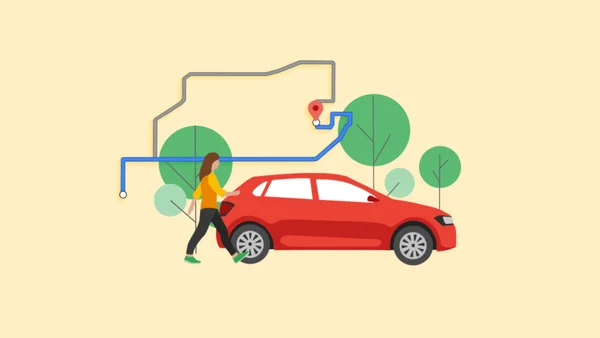 In addition to showing the fastest route, Google Maps will now also display the most fuel efficient one, if it’s not already the fastest.
The tale of the Dutch bookstore, the pivot and the Golden Pin
by Cindy Penders on Sep.02, 2021, under 3D Models, Argentina, Australia, Brazil, California, Denmark, England, Germany, Google Earth News, Google Earth Tips, Google Sky, Google maps, Hawaii, Indonesia, Ireland, Italy, Japan, Kenya, Mexico, Natural Landmarks, Netherlands, Sightseeing, Street Views, USA
Bookstore Dominicanen can be found in a former Dominican church in the city of Maastricht, a thriving cultural hub and one of the oldest cities in The Netherlands. Before COVID, the bookstore welcomed almost one million visitors a year. They mostly relied on customers visiting in person to shop for a good read or to enjoy a coffee while admiring the store’s vault paintings and the unique 14th century fresco depicting scenes from Thomas Aquinas’ life. And then the pandemic hit.
The Covid-19 pandemic has had a major impact on businesses worldwide but it also sparked creativity and accelerated many businesses' use of digital tools. In The Netherlands for example, 81% of Dutch SMEs made more use of digital tools to stay in touch with their customers during the lockdown and inform them about changes in their services.
Dominicanen was one such business to respond to the continuously changing circumstances, something that was recognised by Google with the awarding of the Golden Pin Award.
What are the Golden Pin Awards?
In summer 2021, the Google Netherlands team awarded Golden Pin Awards to twelve inspiring entrepreneurs across the country who managed to continue their services during the pandemic with creativity and the smart use of digital resources whilst receiving high user reviews on their Business Profiles on Google Maps and Search. The list of winners was diverse: from agame store to aknife sharpener, and from a fair fashion clothing shop to a brewery cafe.
The winners all demonstrated creativity in continuing to offer their services both online and offline, ranging from pop up drive-through restaurants to online tastings and fitting sessions for women’s clothing on YouTube.

Bookstore owner Ton Harmes with his Golden Pin
How did Bookstore Dominicanen pivot?
For the owner, Ton Harmes, the key was perseverance. With the store having to close during the busiest weeks of the year - right in the middle of the holiday season - they had to adapt to survive. Their staff and volunteers immediately started delivering books by foot, bicycle and car. They also set up a takeout counter (offering click and collect online) and when numbers of visitors were limited, they decided to launch a pop-up store: Do(mini)canen.
Online, they invested heavily in their visibility on Google and in their social channels to keep in touch with their customers. Prioritising keeping their Business Profile on Google Maps and Search up to date, they were always able to indicate the changes in shopping times and services. Every change was immediately visible for their customers. They also started streaming book presentations and interviews with writers live on YouTube and communicated a lot more through all social media to keep customers informed.
Ton is convinced that the internet will continue to play a role in their business operations now they have reopened. Speaking to The Keyword he said, ‘We realized that with a million visitors a year, it seems like you don't really need these ‘modern developments’. But when we closed it was suddenly dead quiet in the store. Then we realized how vulnerable we are if we rely solely on in-person customers and that we have to develop our digital channels faster. We now see online, even after corona, playing an increasingly important role in our contacts with customers - for both engagement and actually finding us. Our YouTube channel has received a boost and we keep reaching out to customers through our social channels. The crisis has really caused a change in our mindset.’
The Golden Pin Award has been given a special place in the store and serves as a reminder for the perseverance and pivoting that had to be done. Their ability to continue to conduct business through the worst of it is down to what Ton refers to as ‘Haw Pin’: Hold on.
How we’re supporting climate action in European cities
by Rowan Barnett on Oct.02, 2020, under 3D Models, Argentina, Australia, Brazil, California, Denmark, England, Germany, Google Earth, Google Earth News, Google Earth Tips, Google Sky, Google maps, Hawaii, Indonesia, Ireland, Italy, Japan, Kenya, Mexico, Natural Landmarks, Netherlands, Sightseeing, Street Views, USA
Climate action can have the biggest impact in cities, which are responsible for 70 percent of the world's CO₂ emissions. That’s why we committed to helping more than 500 cities reduce 1 gigaton of carbon emissions annually by 2030 as part of our ambitious plan for climate action. To help reach that goal, ICLEI-Local Governments for Sustainability, with grant support from Google.org, is funding six projects. The projects will use actionable data to test new strategies that can reduce emissions and improve air quality in cities across Europe.
ICLEI is a global network of more than 1,750 local and regional governments committed to sustainable urban development. Last fall, we granted $4 million in funding to them to establish the ICLEI Action Fund and support nonprofits and academic institutions in Europe and Latin America that are leading data-driven climate action efforts. Here’s a look at the projects that have been funded and what we’ve learned so far.
Projects selected for funding across Europe
The Centre for Sustainable Energy plans to establish an open-source, city-wide energy dataset in Birmingham, England. The team will also develop analysis tools that can model decarbonisation options for buildings in the city, overlay and integrate public datasets, and aggregate granular socioeconomic data.
With these tools, the Centre hopes to develop city-wide interventions and smaller community initiatives that will help the city reach its overall decarbonisation goals. “By combining emissions data for buildings, transport, and energy infrastructure with socioeconomic data, and distributing local community grants, we’ll be able to help residents deliver targeted carbon reduction projects, and support the City Council and Route to Zero Task Force to deliver their city-wide climate emergency ambitions,” said Rachel Coxcoon, Programme Director at the Centre for Sustainable Energy.
In Hamburg, the CityScienceLab of the HafenCity University will develop a tool incorporating data from Google’s Environmental Insights Explorer (EIE), Hamburg’s urban data platform and other sources. With this tool, they plan to help the city identify areas that can be used as “urban testbeds” for prototyping energy innovations in the Altona, Norg and Bergedorf districts. The prototyping process will help visualise and simulate projects to better understand their projected impact on the city.
Other Action Fund grantees and their projects include:
- Deutsche Umwelthilfe in Berlin: To help the city reach its air quality and carbon-free transport goals, they plan to analyze data about air quality, noise levels and traffic, and use EIE to advocate for data-driven changes to cycling and other transportation infrastructure.
- Carbon Co-Op in Greater Manchester: Working with local partners, they'll develop multi-sector energy plans for the regions and pilot three citizen-led projects focused on sustainable mobility and energy-efficient buildings. A newly developed urban energy dashboard will help them track impact.
- Miljopunkt Amager in Copenhagen: Using Google Air View, traffic data and community-collected data, they’ll test new urban space designs that may improve air quality.
- Air Pays de la Loire in Nantes: Using real-time air quality datasets that account for traffic conditions, they will provide citizens and local authorities with tools to make decisions about transportation management and traffic regulation systems.
The latest insights from cities taking data-driven climate action
Through these projects, we’ve seen how cities are thinking about data-backed sustainability planning and action. So far, we’ve seen trends that can be applied globally.
First, starting small can lead to a big impact—especially when it comes to data. City-level data can point decision-makers in the right direction, while neighborhood or district data can create the necessary community buy-in for more specific programs or interventions. Second, actionable data can help citizens make informed day-to-day decisions and take action. After all, informed citizens are a critical piece of the puzzle. Last, we saw a huge interest in cities looking to improve air quality through more efficient and low-carbon transportation options.
To have a meaningful impact on climate change, data-driven approaches must be scaled across the globe. That’s why Google.org provided ICLEI’s Global Secretariat with additional funding to develop case studies so they can share best practices that emerge from the Action Fund with cities around the world that are looking to implement similar data-driven climate interventions.
One of our goals at Google is to unlock climate ambitions with data, insights, and innovation to overcome today’s climate crisis. We’re excited to continue supporting leading organizations, such as ICLEI, and cities that share that goal.
Image Credit: Google Earth image of Paris, France 2019, Aerodata International Surveys, Maxar Technologies, The GeoInformation Group | InterAtlas
Cities: where climate action can have the most impact
by Rebecca Moore on Sep.14, 2020, under 3D Models, Argentina, Australia, Brazil, California, Denmark, England, Germany, Google Earth, Google Earth News, Google Earth Tips, Google Sky, Google maps, Hawaii, Indonesia, Ireland, Italy, Japan, Kenya, Mexico, Natural Landmarks, Netherlands, Sightseeing, Street Views, USA
Cities bring people and ideas together. They increase living standards, spur innovation, increase opportunity, and encourage collaboration. Cities can also be the most environmentally sustainable way for people to inhabit our planet, if we can address the reality that cities are currently responsible for 70 percent of the world’s CO₂ emissions. While this may seem like an insurmountable challenge, it’s actually a tremendous opportunity. Cities can become centers of climate action, and lead the world in driving economic recovery and resilience.
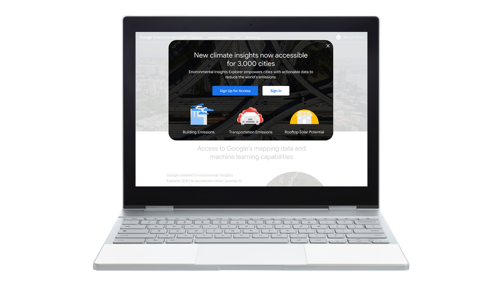
As part of Google's most ambitious decade of climate action, we’re making a commitment to help more than 500 cities and local governments reduce an aggregate of 1 gigaton (that’s one billion tons) of carbon emissions per year by 2030 and beyond.
To do this, we'll empower city planners and policymakers with the Environmental Insights Explorer (EIE), a platform we developed by analyzing Google’s comprehensive global mapping data together with standard greenhouse gas (GHG) emission factors. Today, we’re expanding access to EIE, going from 122 cities with access to more than 3,000 cities worldwide—a 25-fold increase. We’re also partnering with leading organizations, like ICLEI and Ironbark Sustainability, to support local climate action planning.

Turning climate insights into action
For cities to make a meaningful impact in reducing their carbon emissions tomorrow, they need to know where they stand today.
Yet according to the Global Covenant of Mayors, an international alliance of nearly 10,000 cities and local governments committed to fighting climate change, less than 20 percent of cities are able to execute on their commitments to climate action due to a lack of time, resources and data. And with COVID-19 leaving many localities with reduced budgets and limited resources, it’s even harder to build out a baseline emissions inventory or a robust climate plan.
With Environmental Insights Explorer, cities can leapfrog the constraints associated with lengthy climate studies. Cities can use EIE’s anonymized, aggregated mapping data and emissions insights to easily estimate the carbon footprint of their buildings and transportation activities, as well as discover their solar energy potential. Information that once required complicated onsite measurements and months to compile can now be assessed virtually, helping cities dedicate their energies toward action.
Cultivating partnerships with climate action leaders and cities worldwide
When it comes to climate change, we all need to work together. Nonprofits, businesses, universities and other leaders play an important role in testing new ideas and partnering with cities to implement the ones that work.
We’ve collaborated with partners to scale data access. Leading organizations like Local Governments for Sustainability (ICLEI ) and Ironbark Sustainability are integrating EIE data into their own tools, helping digitize emissions measurement and planning. With EIE data, Ironbark Sustainability is automating how they provide greenhouse gas emission information to local government councils across Australia so decision-makers can target their climate action activities.
With the Insights Workspace dashboard in EIE, cities can review and evaluate emissions data. Data for more than 3,000 cities is freely available by registering for access at http://goo.gle/eie.
To help spark even more data-driven climate action, last year Google.org committed $4 million in funding to ICLEI Local Governments for Sustainability to create the ICLEI Action Fund. The fund awards projects from local organizations in Europe, Mexico and South America focused on using environmental datasets to reduce citywide emissions.
Today, ICLEI is announcing the first two selected projects. In Hamburg, HafenCity University is creating a tool to help the city identify spaces and districts that can be used as urban testbeds for prototyping sustainable mobility, building efficiency and solar energy development projects. In Monterrey, Mexico, Instituto Tecnológico de Monterrey received a grant to refine and amplify EIE data to help municipalities in the Monterrey region develop climate action plans. They’ll also use the data to run a model of traffic patterns in Monterrey to assess the electrification of a fleet of buses and how to optimize transit routes.
Supporting economic recovery and resilience with climate action
Efforts to combat climate change are both essential and a once-in-a-generation moment to create impactful jobs and modernize infrastructure. As communities are working to combat, and recover from, a global pandemic, reducing carbon emissions can and should support that recovery.
Already, cities and local governments across the world are using EIE to set bold climate action plans and support economic development:
The opportunity in front of us all
We’ve always viewed challenges as opportunities to be helpful and make things better for everyone. To build a better future and protect our planet, we’ll continue focused efforts that help our partners take climate action and strengthen investments in technologies to make a carbon-free world a reality.
I’m using Google Maps to plan summer family fun
by Katie Malczyk on Aug.11, 2020, under 3D Models, Argentina, Australia, Brazil, California, Denmark, England, Germany, Google Earth News, Google Earth Tips, Google Sky, Google maps, Hawaii, Indonesia, Ireland, Italy, Japan, Kenya, Mexico, Natural Landmarks, Netherlands, Sightseeing, Street Views, USA
Due to COVID-19, this is the summer for staycations and local day trips. In London, where my family and I live, we’re trying to figure out what that looks like for us. We have a toddler, so our ideal day trip is somewhere she can run around and we can have a picnic—and where the public restrooms have reopened (or, failing that, a discreet wooded area…).
So how do I find a destination that checks all our boxes? Here’s what’s worked.
Meet at a fun halfway point
My cousin and her family live about a two-hour drive from us, and when lockdown lifted we were more than ready to meet up. But instead of driving all the way to them—a four-hour round trip is a struggle for even the most patient of toddlers—we had the idea to meet up at a halfway point.
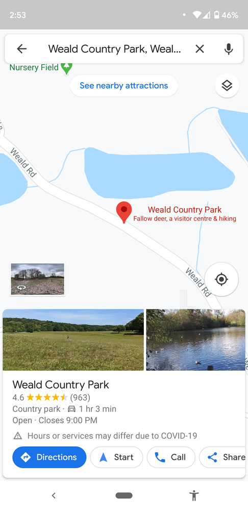
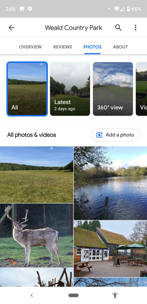
But how do you find that halfway point? That space between us was a no-man’s land where neither of us knew of any parks or nature reserves or anywhere that would be suitable for two energetic toddlers. So I used Google Maps to find the rough halfway point. Then I filtered by “Attractions” (you can also choose “Parks” or “Restaurants” or other categories) to see what came up. I quickly landed on Weald Country Park, which boasts a 4.5-star rating, almost a thousand reviews and a promising description: “Fallow deer, a visitor center & hiking.”
Read the reviews
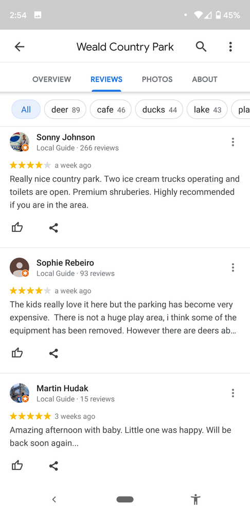
Deer-watching had the potential to keep toddlers occupied for at least one minute. A visitor center indicated parking and bathrooms. And hiking probably meant that picnicking was easily an option. But to double-check these critical questions, I relied on the kindness of strangers who had posted recent reviews and ratings. Local Guides and other people who contribute to Google Maps are very helpful in offering information about how much they liked (or didn’t like) their trip, and many of them have the same topics on their mind that I do. Since you can sort reviews by date, it was easy to see the most relevant ones—i.e., those that have been filed since lockdown lifted—for current info on toilets (yes), parking (yes, but it’s expensive), and whether the playgrounds have reopened (yes, very recently).
Browse the photos and Street View
To really get a feel for a place, sometimes there’s no replacement for a photo. Happily, many Google Maps contributors feel the same way, so it’s often very easy to find recent photos of the places you’re thinking of visiting. And for a 360-degree panorama, I can drop the pin and check out the scene on Street View. I soon discovered that, in addition to deer, Weald Country Park is home to cows and ducks, making it more or less heaven on earth for two two-year-olds.
Save places and make lists
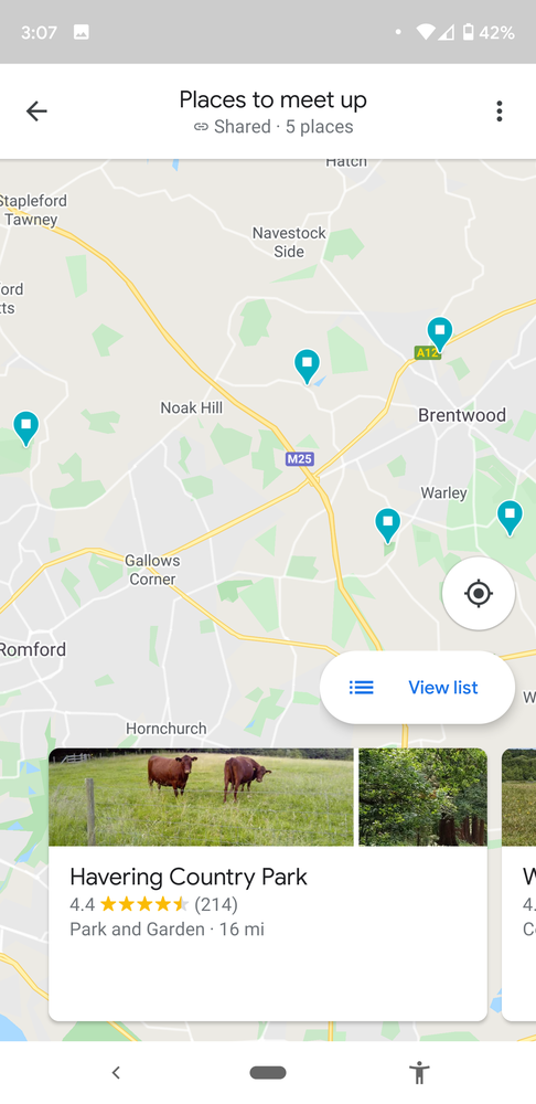
I know that we’ll want to meet up with my cousin’s family again soon, and there were a few other nearby nature reserves that looked equally promising. So I tapped the “Save” button to start a list I could refer back to. I can even share it with my cousin so we can work on the list together. Google Maps puts a pin in them too, so the next time I’m scouting the area I’ll see little flags helpfully highlighting them for me.
Contribute your own review
If you found someone’s review or photos helpful, why not pay it forward by posting your own? If you’ve found information that needs updating, like a store’s opening hours, or if you want to let people know how your experience of a place matched up to expectations, click on the Contribute button at the bottom of the screen on the Google Maps app and share your knowledge.
Street View is helping this tour guide stay in business
by Katie Malczyk on Apr.24, 2020, under 3D Models, Argentina, Australia, Brazil, California, Denmark, England, Germany, Google Earth News, Google Earth Tips, Google Sky, Google maps, Hawaii, Indonesia, Ireland, Italy, Japan, Kenya, Mexico, Natural Landmarks, Netherlands, Sightseeing, Street Views, USA
On March 24, government restrictions due to COVID-19 went into effect across the United Kingdom. With nonessential businesses forced to close, public gatherings banned, and most people required to stay at home, these regulations instantly transformed daily life. They also presented a serious threat to Katie Wignall’s business: Katie makes her living as a tour guide, showing curious visitors the highlights of London.
But instead of trying to simply wait out the crisis, Katie looked to technology for a solution to creatively keep her business going. We chatted with her to find out how she’s successfully managed to take her walking tours virtual.

One of the beaver statues on Oxford Street
Describe your business, Look Up London.
I provide walking tours all over London for public and private groups. I’m a Blue Badge Tourist Guide, which is the top accreditation for tourist guides in the UK. We do two years of training, pass 11 exams, and we’re the only guides that can take you inside the Tower of London and Westminster Abbey.
Look Up London started originally as a blog and social media channels, where I shared quirkier bits of London history. The name is all about spotting the little details in the architecture around you, to tell the story of why something looks the way it does. For example, on Oxford Street, which is famous for its shopping, there's a building decorated with sculptures of beavers. They're a clue to the fact it used to be a hat factory—slightly gruesome, but a detail that is so often missed by passersby!
How has your business been impacted by COVID-19 and the government restrictions?
I’ve had to shut down, basically. I can’t go out; we’re not able to meet up in groups to deliver the normal tours. All of the work I had booked going into the summer—the busiest time—has just been cancelled or postponed. Literally overnight there was no work at all.
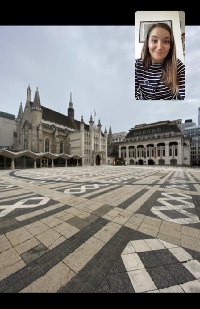
Katie giving a tour of the Guildhall
What gave you the idea for virtual tours?
It was actually a suggestion from a follower on Instagram who asked, “Is there a way you could do virtual tours?” I started out by going out myself and having my husband film me on London streets, but then as the situation escalated, we weren’t allowed outside.
So then I thought I’d experiment with Google Street View. If I couldn’t go outside, I could offer people the next best thing, through a screen. I was already using Street View a lot for my work—it’s really good for my research. I love the feature where you can go back in time. It’s not possible for every location, but for a lot of central London, you can select a place in Google Maps for desktop, drag the Street View pegman into the picture and click on the clock in the top left corner to explore imagery from the past. You can see where buildings have been demolished and what used to be standing where.
So now, every Monday, Wednesday and Friday at 2 PM London time, I use Street View to give a virtual tour on Instagram Live. And for anyone who can’t make that time, I post the recordings on my website. They’re all free, and if people enjoy them, they can make a donation.What’s been the response?
People have been so lovely. From the comments, I think it’s been very helpful for people in lockdown, who maybe are older and can’t get out of the house as often, or people who’ve had to leave London and are feeling homesick. Lots have messaged me to say it’s made them feel like they’ve been outside. They’ve really learned something new and taken their minds off the situation for twenty minutes or so.
Any advantages to using Street View compared to being there in person?
The great thing about Street View is that you can hop about—you can jump a mile down the road and people don’t have to get on a bus or actually walk, so you can cover a lot of ground.
And then there’s that feature to go back in time and see things how they appeared years ago, back to 2008. On a normal tour, you can show pictures and give people an idea, but if people are on Street View and feel like they’re standing in a space and seeing the changes right there, it’s a different experience.
One example, on my Aldgate tour, is a garden space that has been relandscaped. The garden looks beautiful now, but three years ago you could see the cobbles of Victorian London. And those cobbles happen to have been the site of the murder of Catherine Eddowes, who was a victim of Jack the Ripper. That was an evocative thing to be able to show.
Any advice for other small business owners who are trying to figure out how to adapt right now?
I think you have to do the thing that you enjoy doing. I don’t think I’d be able to do these three times a week if I didn’t enjoy them. If you have something that you want to share, there’s no reason you shouldn’t do that. Technology has made everything so accessible, and if you care about something, chances are others care about that as well.
Street View is helping this tour guide stay in business
by Katie Malczyk on Apr.24, 2020, under 3D Models, Argentina, Australia, Brazil, California, Denmark, England, Germany, Google Earth News, Google Earth Tips, Google Sky, Google maps, Hawaii, Indonesia, Ireland, Italy, Japan, Kenya, Mexico, Natural Landmarks, Netherlands, Sightseeing, Street Views, USA
On March 24, government restrictions due to COVID-19 went into effect across the United Kingdom. With nonessential businesses forced to close, public gatherings banned, and most people required to stay at home, these regulations instantly transformed daily life. They also presented a serious threat to Katie Wignall’s business: Katie makes her living as a tour guide, showing curious visitors the highlights of London.
But instead of trying to simply wait out the crisis, Katie looked to technology for a solution to creatively keep her business going. We chatted with her to find out how she’s successfully managed to take her walking tours virtual.
One of the beaver statues on Oxford Street
Describe your business, Look Up London.
I provide walking tours all over London for public and private groups. I’m a Blue Badge Tourist Guide, which is the top accreditation for tourist guides in the UK. We do two years of training, pass 11 exams, and we’re the only guides that can take you inside the Tower of London and Westminster Abbey.
Look Up London started originally as a blog and social media channels, where I shared quirkier bits of London history. The name is all about spotting the little details in the architecture around you, to tell the story of why something looks the way it does. For example, on Oxford Street, which is famous for its shopping, there's a building decorated with sculptures of beavers. They're a clue to the fact it used to be a hat factory—slightly gruesome, but a detail that is so often missed by passersby!
How has your business been impacted by COVID-19 and the government restrictions?
I’ve had to shut down, basically. I can’t go out; we’re not able to meet up in groups to deliver the normal tours. All of the work I had booked going into the summer—the busiest time—has just been cancelled or postponed. Literally overnight there was no work at all.
Katie giving a tour of the Guildhall
What gave you the idea for virtual tours?
It was actually a suggestion from a follower on Instagram who asked, “Is there a way you could do virtual tours?” I started out by going out myself and having my husband film me on London streets, but then as the situation escalated, we weren’t allowed outside.
So then I thought I’d experiment with Google Street View. If I couldn’t go outside, I could offer people the next best thing, through a screen. I was already using Street View a lot for my work—it’s really good for my research. I love the feature where you can go back in time. It’s not possible for every location, but for a lot of central London, you can select a place in Google Maps for desktop, drag the Street View pegman into the picture and click on the clock in the top left corner to explore imagery from the past. You can see where buildings have been demolished and what used to be standing where.
So now, every Monday, Wednesday and Friday at 2 PM London time, I use Street View to give a virtual tour on Instagram Live. And for anyone who can’t make that time, I post the recordings on my website. They’re all free, and if people enjoy them, they can make a donation.What’s been the response?
People have been so lovely. From the comments, I think it’s been very helpful for people in lockdown, who maybe are older and can’t get out of the house as often, or people who’ve had to leave London and are feeling homesick. Lots have messaged me to say it’s made them feel like they’ve been outside. They’ve really learned something new and taken their minds off the situation for twenty minutes or so.
Any advantages to using Street View compared to being there in person?
The great thing about Street View is that you can hop about—you can jump a mile down the road and people don’t have to get on a bus or actually walk, so you can cover a lot of ground.
And then there’s that feature to go back in time and see things how they appeared years ago, back to 2008. On a normal tour, you can show pictures and give people an idea, but if people are on Street View and feel like they’re standing in a space and seeing the changes right there, it’s a different experience.
One example, on my Aldgate tour, is a garden space that has been relandscaped. The garden looks beautiful now, but three years ago you could see the cobbles of Victorian London. And those cobbles happen to have been the site of the murder of Catherine Eddowes, who was a victim of Jack the Ripper. That was an evocative thing to be able to show.
Any advice for other small business owners who are trying to figure out how to adapt right now?
I think you have to do the thing that you enjoy doing. I don’t think I’d be able to do these three times a week if I didn’t enjoy them. If you have something that you want to share, there’s no reason you shouldn’t do that. Technology has made everything so accessible, and if you care about something, chances are others care about that as well.
My doctor’s advice turned me into a Local Guide
by Jan Van Haver on Dec.16, 2019, under 3D Models, Argentina, Australia, Brazil, California, Denmark, England, Germany, Google Earth News, Google Earth Tips, Google Sky, Google maps, Hawaii, Indonesia, Ireland, Italy, Japan, Kenya, Mexico, Natural Landmarks, Netherlands, Sightseeing, Street Views, USA
A couple of years ago I turned 50, which seemed like the perfect time to visit our family doctor for a checkup. The verdict was: "You need more exercise, Jan." (Not really surprising for someone who has a desk job.)
At first, I bought a decent bicycle and used it occasionally, but pretty soon those occasions started to decrease significantly. I also enjoy hiking in the countryside with my wife, but with two busy schedules to manage, that isn’t always possible.
During one of those hikes, however, I was testing the camera on my new smartphone. All of a sudden, a pop-up appeared asking me if I would like to upload the picture I had just taken to Google Maps. I tapped “Yes,” a decision that would change my life.
After about a week, another notification popped up to tell me that my photo had already been viewed 70 times, which came as a total surprise. Digging a bit deeper, I discovered that this was the result of a program called Local Guides, where people add their own information to Google Maps. It was open to anyone 18 and over with a Google account: All I had to do was sign up and start adding information, and I became a Level 1 Local Guide. Not only could Local Guides upload pictures, but they could also write reviews of local businesses and edit information (like opening hours or telephone numbers). They could even add missing places to Google Maps.
Pretty soon I was making Local Guide trips. I strolled through nearby cities, smartphone in hand (I quickly added a spare battery pack to my shopping list), taking a picture here, adding a newly opened bakery there.
Jan at the Connect Live conference in California
A few weeks into it, I discovered exactly how helpful my new hobby could be when my stepdaughter got completely lost during a trip to a nearby town. Her destination was an office that had recently moved to a new location. And although the street address had technically been updated on Maps, the map marker (the red pin showing the exact location on the map) hadn’t been moved. It led her to the old address (with 5% battery life and 95% anxiety). Now that I’d been a Local Guide for a little while, I could simply drag and drop the pin to the new location. Within seconds, it was available to anyone searching for it.
And thus a passion and a mission were born. In fact, I now host a podcast dedicated to helping fellow Local Guides develop their skills, and post regular tips on my blog.
Thanks to all those health-conscious walking trips, I’ve made thousands of contributions (it helps that you get points for each contribution and thereby rise to higher Local Guide levels). And I’ve discovered a vibrant community of Local Guides who come together online and at occasional meetups in real life. I was recently invited to attend the biggest meetup of them all, Connect Live at Google’s headquarters in California. I had the opportunity to talk with some of the Maps team members in Mountain View, and meet 199 other Guides who are as passionate about this hobby as I am.
Looking back on that doctor’s visit now, it’s possibly the best advice I ever received.