Tag: covid-19
Get around safely with these new Google Maps features
by Ramesh Nagarajan on Jun.08, 2020, under 3D Models, Argentina, Australia, Brazil, California, Denmark, England, Germany, Google Earth News, Google Earth Tips, Google Sky, Google maps, Hawaii, Indonesia, Ireland, Italy, Japan, Kenya, Mexico, Natural Landmarks, Netherlands, Sightseeing, Street Views, USA
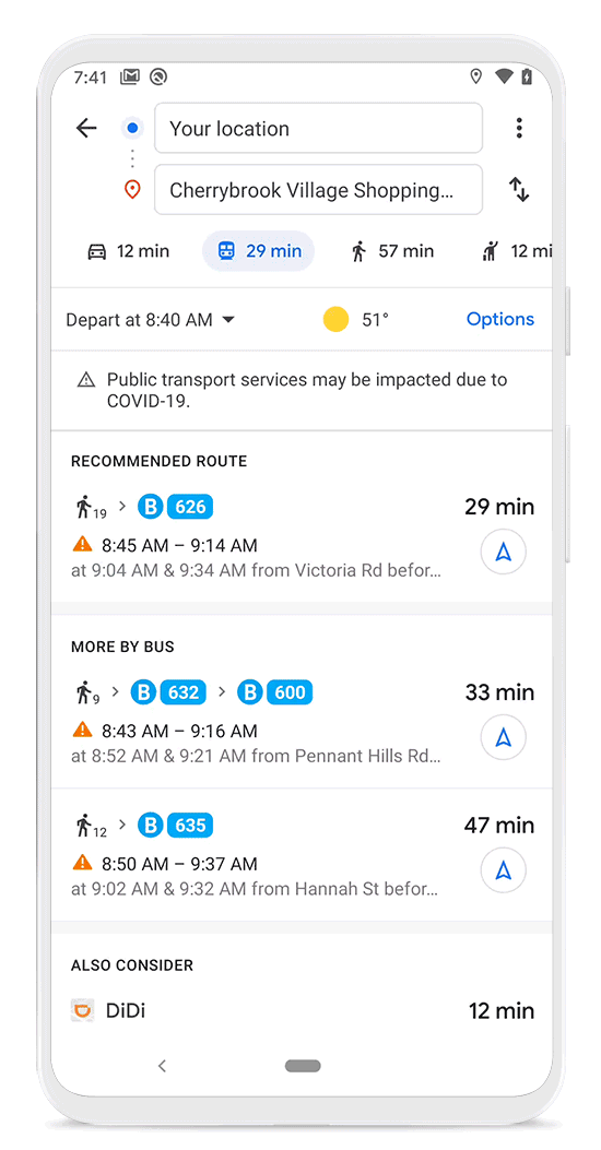
Getting from A to B can be more complicated these days. Because of COVID-19, it’s increasingly important to know how crowded a train station might be at a particular time or whether the bus is running on a limited schedule. Having this information before and during your trip is critical for both essential workers who need to safely navigate to work and will become more important for everyone as countries around the world begin to reopen.
In our latest release of Google Maps on Android and iOS, we’re introducing features to help you easily find important information if you need to venture out, whether it’s by car or public transportation.
Get alerts about important information
When you look up public transit directions for a trip that is likely to be affected by COVID-19 restrictions, we’ll show relevant alerts from local transit agencies. These alerts can help you prepare accordingly if government mandates impact transit services or require you to wear a mask on public transportation. Transit alerts are rolling out in Argentina, Australia, Belgium, Brazil, Colombia, France, India, Mexico, Netherlands, Spain, Thailand, United Kingdom and the U.S. where we have information from local transit agencies, with more coming soon.
We’re also introducing driving alerts to notify you about COVID-19 checkpoints and restrictions along your route, like when crossing national borders (starting first in Canada, Mexico and the U.S.). You’ll see an alert on the directions screen and after starting navigation if your route is impacted by these restrictions.
When navigating to medical facilities or COVID-19 testing centers, we’ll display an alert reminding you to verify eligibility and facility guidelines to avoid being turned away or causing additional strain on the local healthcare system. Starting this week, alerts for medical facilities will be available in Indonesia, Israel, the Philippines, South Korea, and the U.S., and testing center alerts will be available in the U.S.
We’re showing these alerts where we’ve received authoritative data from local, state and federal governments or from their websites, and are actively working with other agencies around the world to bring even more of this helpful data to users in Google Maps. Interested agencies can get in touch here for driving restrictions and here for transit alerts.
Safely avoid crowds on public transit
Last year, we introduced crowdedness predictions for public transit in Google Maps. Powered by tens of millions of contributions from past riders, these predictions help people see how crowded a particular bus line or train tends to be. We’re now making it simpler for people to contribute crowdedness information for their transit lines. Look up Directions, tap through to see the Transit Details, then scroll down to find crowdedness predictions (where available) and easily contribute your own experiences.
Additionally, in February, we announced new insights like temperature, accessibility and security onboard, as well as designated women’s sections in regions where transit systems have them. These insights are now rolled out globally, helping you find feedback from past riders when available and submit your own, right alongside public transit routes. To help wheelchair users around the world know before they go, we’ve added more granular accessibility information for people to find and contribute, including where there are wheelchair accessible doors, seating, stop buttons and more.
Find and contribute crowdedness information for transit lines.
To ensure proper social distancing, commuters are paying attention to how crowded or comfortable their ride and transit station will be. Starting today, you can easily see the times when a transit station is historically more or less busy to plan your trip accordingly or you can look at live data showing how busy it is right now compared to its usual level of activity. Simply search for a station in Google Maps or tap on the station on the map to see the departure board and busyness data, where available. Rolling out over the next several weeks, these capabilities are powered by aggregated and anonymized data from users who have opted in to Google Location History, a Google account-level setting that is off by default. To protect privacy, these insights are only surfaced when we have sufficient data to meet privacy thresholds.
See popular times for a transit station and how busy it is at that moment.
COVID-19 has certainly impacted the way that we move around in the world. As cities and countries across the globe adapt, we’re committed to bringing the most pertinent information right to your fingertips. So when you’re ready and able to, you can safely venture out.
Google’s new tools help businesses during COVID-19
by Jen Fitzpatrick on May.27, 2020, under 3D Models, Argentina, Australia, Brazil, California, Denmark, England, Germany, Google Earth News, Google Earth Tips, Google Sky, Google maps, Hawaii, Indonesia, Ireland, Italy, Japan, Kenya, Mexico, Natural Landmarks, Netherlands, Sightseeing, Street Views, USA
Running a business requires a whole lot of ingenuity and perseverance. It’s those same qualities that are helping local businesses adapt, and even thrive, in today’s new normal. To adjust, business owners are increasingly turning to digital tools. According to a newly released report by the Connected Commerce Council, nearly one in three small business owners said that without digital tools they would have had to close all or parts of their business.
We’ve rolled out new features to help businesses get the support they need, adapt their operations, and quickly update customers about their latest changes.
Let people know how they can help
We’ve seen firsthand in Google Search and Maps the impact that COVID-19 has had on small businesses and how they connect with their customers. People across the world are looking for ways to continue supporting corner bookstores, local watering holes, beloved dance studios and other businesses that give their neighborhoods character—even if it’s from a distance.
To help local businesses share how their communities can support them during COVID-19, we recently began allowing merchants in six countries to add support links for donations and gift cards to their Business Profiles on Google. Starting today, we’re rolling support links out to merchants in an additional 18 countries such as Italy, Spain and Japan. We’ve partnered with PayPal and GoFundMe for donations. For gift cards, merchants can link directly to the relevant page on their website or to their gift card offerings with one of our eligible partners, which includes Square, Toast, Clover and Vagaro.
People around the world are looking to help—with global search interest in "how to help small businesses" reaching an all-time high in March 2020, increasing more than 700 percent since February. To help connect them with nearby businesses in need, we’ve made it possible for people to look up their favorite local businesses by name to see if they’ve added donation or gift card links to their Business Profile. And in the coming weeks, people will also be able to use Search and Maps to find all of the nearby businesses that are asking for support.

People can now look up their favorite local businesses to see if they have donation or gift card links on their Business Profile
Transition to online services with ease
Merchants who normally provided in-person services are now pivoting to connect with their customers virtually—from yoga studios offering online classes to salons hosting virtual hair styling classes. We’re making it easier for customers to discover online classes and book virtual appointments with these new features:
Get discovered:Merchants who are verified on Google My Business will soon be able to add attributes like “online classes,” “online appointments,” or “online estimates” to their Business Profiles to let people know how they’re operating. Today merchants can add one of these attributes using Google My Business, and in the coming weeks it’ll be visible on merchants’ Business Profiles in Search and Maps.
Online service bookings directly on Google:We’re expanding Reserve with Google to help merchants offer easy appointment bookings for online services so customers can quickly find available times, book a slot, and add it to their Google Calendar—all directly from a merchant’s Business Profile. Millions of people have already booked in-person appointments with salons, restaurants and other businesses thanks to integrations from over 100 Reserve with Google partners. We’re now expanding this to include bookings for online services, starting with partners like Booksy, Regis, WellnessLiving, and Zooty. Merchants working with one of these partners can offer online bookings directly on Google and share details with customers about how to pay and join the meeting using their preferred video platform.

Merchants can offer easy appointment bookings for online services.
Keep everyone in the know with the latest business information
Sometimes it’s not as simple as “open” and “closed.” Since the beginning of the pandemic, we’ve added new tools to help merchants keep customers informed about how and when they’re operating.
Across all business verticals, we launched the ability to mark their business as temporarily closed, as well as reopen when they’re ready to open their doors. We also added secondary hours and COVID-19 posts so merchants can communicate important information about their operations directly in Google Search and Maps. Since March, we’ve seen more than 1 million businesses share COVID-19 posts, with millions of clicks to merchants’ websites every week as consumers look for more information.
With many people unable to enjoy meals inside their favorite restaurants, demand for food delivery and takeout has skyrocketed. In response, we’ve added more third-party ordering providers, so people everywhere can order delivery and takeout from an additional 25,000 restaurants directly on Google. To give merchants even more control, we’ll soon be making it easier for food merchants to indicate their preferred online ordering partners on their Business Profiles.
Today people are deciding where to grab food not only based on the menu, but also on how easy it is to pick up safely. We added attributes like “curbside pickup,” “no contact delivery,” and “dine-in” so that restaurants could easily share these important details on their Business Profiles in Search and Maps. Since March, more than 3 million restaurants have added or edited their dining attributes. Some restaurateurs are even ditching dining areas for good. To support all types of food merchants, virtual kitchens can now verify their businesses on Google My Business.
We know that every day during this pandemic can be drastically different—and for small business owners, there can be a lot of uncertainty. While we can’t control what each day looks like, our goal is to continue helping businesses communicate the latest with consumers across the world.
Maps that bring us closer, even when we’re apart
by Chris Herwig on Apr.29, 2020, under 3D Models, Argentina, Australia, Brazil, California, Denmark, England, Germany, Google Earth, Google Earth News, Google Earth Tips, Google Sky, Google maps, Hawaii, Indonesia, Ireland, Italy, Japan, Kenya, Mexico, Natural Landmarks, Netherlands, Sightseeing, Street Views, USA
With much of the world physically apart right now, people are finding creative ways to use custom-built maps to maintain a shared sense of community, albeit virtually.
In 2007, we launched a tool called My Maps to help people create their own custom maps on top of Google Maps. With a simple drag-and-drop interface you can add placemarks, draw lines and shapes, and embed text, photos and videos. You can share your map via public URL, embed it on websites or publish your map for others to see.
Over the past four months, we’ve seen a surge in the number of people creating and viewing My Maps. From December 2019 to April 2020, we saw nearly a billion more My Maps creations, edits and views compared to the same time period last year, growing from 2 billion to nearly 3 billion. With My Maps, communities have been sharing helpful, local information in rapidly changing situations—from COVID-19 testing sites and food banks to where first responders can access childcare facilities.
Maps can help us and our communities stay safe
A map can be helpful in ways that a simple list of text is not: it helps us instantly see information in the context of where we are, with the locations of the resources we might need.
With My Maps, anyone can be a cartographer. People can import their own data into a custom map, similar to how the San Francisco Department of Homelessness & Supportive Housing mapped downtown hand-washing and hygiene stations to support hand hygiene and reduce the spread of COVID-19. With a spreadsheet or KML you can have your own custom map in no time.
Some maps take a bit more than hand-drawn points and polygons. For that, My Maps creators can import their own mapping data and mash it up with other sources.
For example, the online newspaper Briarcliff Daily Voice created a My Map showing the spread of coronavirus cases in the New York City metropolitan area, using data from three state healthcare agencies and the city’s health department. Pennsylvania.gov has leveraged My Maps to inform Pennsylvanians about coronavirus cases by county. And The Chicago Sun-Times has a map showing where to get tested for coronavirus in the Chicago area.

Anyone can be a force for good with simple, easy-to-use maps
In the past few months, we've seen how powerful this small set of relatively simple features can be. People are using My Maps to to be forces for good and coordinate relief efforts.
Map by map, people are connecting each other to resources for caring for ourselves and others, while staying healthy and informed. We’re seeing everyone from members of Congress to local nonprofits use Google My Maps to visualize information like school lunch pick-up spots to the spread of the virus in our communities.
Here are 10 helpful My Maps we’ve seen developed by communities around the world:
Keeping a shared sense of community, even when you're physically apart
As much as these maps are informative and helpful, they’re also uplifting. After a group of Brooklyn, NY moms asked neighbors to put pictures of rainbows in house windows so kids could track them down, one woman created a map showing the rainbows’ locations all over the city and suburbs. Now people worldwide are pitching in and adding their own rainbow locations to the map.

If you’d like to experiment with My Maps, we’re putting together tutorials on skills like merging datasets and embedding maps online. Visit the Google Earth Medium channel in the coming weeks to learn more.
Maps that bring us closer, even when we’re apart
by Chris Herwig on Apr.29, 2020, under 3D Models, Argentina, Australia, Brazil, California, Denmark, England, Germany, Google Earth, Google Earth News, Google Earth Tips, Google Sky, Google maps, Hawaii, Indonesia, Ireland, Italy, Japan, Kenya, Mexico, Natural Landmarks, Netherlands, Sightseeing, Street Views, USA
With much of the world physically apart right now, people are finding creative ways to use custom-built maps to maintain a shared sense of community, albeit virtually.
In 2007, we launched a tool called My Maps to help people create their own custom maps on top of Google Maps. With a simple drag-and-drop interface you can add placemarks, draw lines and shapes, and embed text, photos and videos. You can share your map via public URL, embed it on websites or publish your map for others to see.
Over the past four months, we’ve seen a surge in the number of people creating and viewing My Maps. From December 2019 to April 2020, we saw nearly a billion more My Maps creations, edits and views compared to the same time period last year, growing from 2 billion to nearly 3 billion. With My Maps, communities have been sharing helpful, local information in rapidly changing situations—from COVID-19 testing sites and food banks to where first responders can access childcare facilities.
Maps can help us and our communities stay safe
A map can be helpful in ways that a simple list of text is not: it helps us instantly see information in the context of where we are, with the locations of the resources we might need.
With My Maps, anyone can be a cartographer. People can import their own data into a custom map, similar to how the San Francisco Department of Homelessness & Supportive Housing mapped downtown hand-washing and hygiene stations to support hand hygiene and reduce the spread of COVID-19. With a spreadsheet or KML you can have your own custom map in no time.
Some maps take a bit more than hand-drawn points and polygons. For that, My Maps creators can import their own mapping data and mash it up with other sources.
For example, the online newspaper Briarcliff Daily Voice created a My Map showing the spread of coronavirus cases in the New York City metropolitan area, using data from three state healthcare agencies and the city’s health department. Pennsylvania.gov has leveraged My Maps to inform Pennsylvanians about coronavirus cases by county. And The Chicago Sun-Times has a map showing where to get tested for coronavirus in the Chicago area.
Anyone can be a force for good with simple, easy-to-use maps
In the past few months, we've seen how powerful this small set of relatively simple features can be. People are using My Maps to to be forces for good and coordinate relief efforts.
Map by map, people are connecting each other to resources for caring for ourselves and others, while staying healthy and informed. We’re seeing everyone from members of Congress to local nonprofits use Google My Maps to visualize information like school lunch pick-up spots to the spread of the virus in our communities.
Here are 10 helpful My Maps we’ve seen developed by communities around the world:
Keeping a shared sense of community, even when you're physically apart
As much as these maps are informative and helpful, they’re also uplifting. After a group of Brooklyn, NY moms asked neighbors to put pictures of rainbows in house windows so kids could track them down, one woman created a map showing the rainbows’ locations all over the city and suburbs. Now people worldwide are pitching in and adding their own rainbow locations to the map.
If you’d like to experiment with My Maps, we’re putting together tutorials on skills like merging datasets and embedding maps online. Visit the Google Earth Medium channel in the coming weeks to learn more.
Street View is helping this tour guide stay in business
by Katie Malczyk on Apr.24, 2020, under 3D Models, Argentina, Australia, Brazil, California, Denmark, England, Germany, Google Earth News, Google Earth Tips, Google Sky, Google maps, Hawaii, Indonesia, Ireland, Italy, Japan, Kenya, Mexico, Natural Landmarks, Netherlands, Sightseeing, Street Views, USA
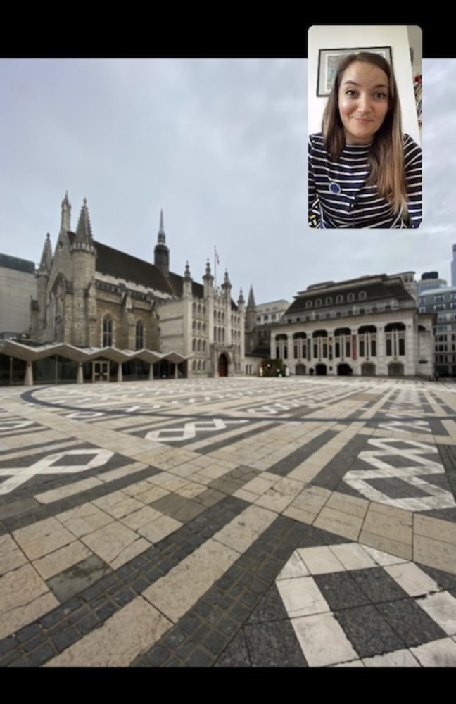
On March 24, government restrictions due to COVID-19 went into effect across the United Kingdom. With nonessential businesses forced to close, public gatherings banned, and most people required to stay at home, these regulations instantly transformed daily life. They also presented a serious threat to Katie Wignall’s business: Katie makes her living as a tour guide, showing curious visitors the highlights of London.
But instead of trying to simply wait out the crisis, Katie looked to technology for a solution to creatively keep her business going. We chatted with her to find out how she’s successfully managed to take her walking tours virtual.

One of the beaver statues on Oxford Street
Describe your business, Look Up London.
I provide walking tours all over London for public and private groups. I’m a Blue Badge Tourist Guide, which is the top accreditation for tourist guides in the UK. We do two years of training, pass 11 exams, and we’re the only guides that can take you inside the Tower of London and Westminster Abbey.
Look Up London started originally as a blog and social media channels, where I shared quirkier bits of London history. The name is all about spotting the little details in the architecture around you, to tell the story of why something looks the way it does. For example, on Oxford Street, which is famous for its shopping, there's a building decorated with sculptures of beavers. They're a clue to the fact it used to be a hat factory—slightly gruesome, but a detail that is so often missed by passersby!
How has your business been impacted by COVID-19 and the government restrictions?
I’ve had to shut down, basically. I can’t go out; we’re not able to meet up in groups to deliver the normal tours. All of the work I had booked going into the summer—the busiest time—has just been cancelled or postponed. Literally overnight there was no work at all.
Katie giving a tour of the Guildhall
What gave you the idea for virtual tours?
It was actually a suggestion from a follower on Instagram who asked, “Is there a way you could do virtual tours?” I started out by going out myself and having my husband film me on London streets, but then as the situation escalated, we weren’t allowed outside.
So then I thought I’d experiment with Google Street View. If I couldn’t go outside, I could offer people the next best thing, through a screen. I was already using Street View a lot for my work—it’s really good for my research. I love the feature where you can go back in time. It’s not possible for every location, but for a lot of central London, you can select a place in Google Maps for desktop, drag the Street View pegman into the picture and click on the clock in the top left corner to explore imagery from the past. You can see where buildings have been demolished and what used to be standing where.
So now, every Monday, Wednesday and Friday at 2 PM London time, I use Street View to give a virtual tour on Instagram Live. And for anyone who can’t make that time, I post the recordings on my website. They’re all free, and if people enjoy them, they can make a donation.What’s been the response?
People have been so lovely. From the comments, I think it’s been very helpful for people in lockdown, who maybe are older and can’t get out of the house as often, or people who’ve had to leave London and are feeling homesick. Lots have messaged me to say it’s made them feel like they’ve been outside. They’ve really learned something new and taken their minds off the situation for twenty minutes or so.
Any advantages to using Street View compared to being there in person?
The great thing about Street View is that you can hop about—you can jump a mile down the road and people don’t have to get on a bus or actually walk, so you can cover a lot of ground.
And then there’s that feature to go back in time and see things how they appeared years ago, back to 2008. On a normal tour, you can show pictures and give people an idea, but if people are on Street View and feel like they’re standing in a space and seeing the changes right there, it’s a different experience.
One example, on my Aldgate tour, is a garden space that has been relandscaped. The garden looks beautiful now, but three years ago you could see the cobbles of Victorian London. And those cobbles happen to have been the site of the murder of Catherine Eddowes, who was a victim of Jack the Ripper. That was an evocative thing to be able to show.
Any advice for other small business owners who are trying to figure out how to adapt right now?
I think you have to do the thing that you enjoy doing. I don’t think I’d be able to do these three times a week if I didn’t enjoy them. If you have something that you want to share, there’s no reason you shouldn’t do that. Technology has made everything so accessible, and if you care about something, chances are others care about that as well.
Street View is helping this tour guide stay in business
by Katie Malczyk on Apr.24, 2020, under 3D Models, Argentina, Australia, Brazil, California, Denmark, England, Germany, Google Earth News, Google Earth Tips, Google Sky, Google maps, Hawaii, Indonesia, Ireland, Italy, Japan, Kenya, Mexico, Natural Landmarks, Netherlands, Sightseeing, Street Views, USA
On March 24, government restrictions due to COVID-19 went into effect across the United Kingdom. With nonessential businesses forced to close, public gatherings banned, and most people required to stay at home, these regulations instantly transformed daily life. They also presented a serious threat to Katie Wignall’s business: Katie makes her living as a tour guide, showing curious visitors the highlights of London.
But instead of trying to simply wait out the crisis, Katie looked to technology for a solution to creatively keep her business going. We chatted with her to find out how she’s successfully managed to take her walking tours virtual.
One of the beaver statues on Oxford Street
Describe your business, Look Up London.
I provide walking tours all over London for public and private groups. I’m a Blue Badge Tourist Guide, which is the top accreditation for tourist guides in the UK. We do two years of training, pass 11 exams, and we’re the only guides that can take you inside the Tower of London and Westminster Abbey.
Look Up London started originally as a blog and social media channels, where I shared quirkier bits of London history. The name is all about spotting the little details in the architecture around you, to tell the story of why something looks the way it does. For example, on Oxford Street, which is famous for its shopping, there's a building decorated with sculptures of beavers. They're a clue to the fact it used to be a hat factory—slightly gruesome, but a detail that is so often missed by passersby!
How has your business been impacted by COVID-19 and the government restrictions?
I’ve had to shut down, basically. I can’t go out; we’re not able to meet up in groups to deliver the normal tours. All of the work I had booked going into the summer—the busiest time—has just been cancelled or postponed. Literally overnight there was no work at all.
Katie giving a tour of the Guildhall
What gave you the idea for virtual tours?
It was actually a suggestion from a follower on Instagram who asked, “Is there a way you could do virtual tours?” I started out by going out myself and having my husband film me on London streets, but then as the situation escalated, we weren’t allowed outside.
So then I thought I’d experiment with Google Street View. If I couldn’t go outside, I could offer people the next best thing, through a screen. I was already using Street View a lot for my work—it’s really good for my research. I love the feature where you can go back in time. It’s not possible for every location, but for a lot of central London, you can select a place in Google Maps for desktop, drag the Street View pegman into the picture and click on the clock in the top left corner to explore imagery from the past. You can see where buildings have been demolished and what used to be standing where.
So now, every Monday, Wednesday and Friday at 2 PM London time, I use Street View to give a virtual tour on Instagram Live. And for anyone who can’t make that time, I post the recordings on my website. They’re all free, and if people enjoy them, they can make a donation.What’s been the response?
People have been so lovely. From the comments, I think it’s been very helpful for people in lockdown, who maybe are older and can’t get out of the house as often, or people who’ve had to leave London and are feeling homesick. Lots have messaged me to say it’s made them feel like they’ve been outside. They’ve really learned something new and taken their minds off the situation for twenty minutes or so.
Any advantages to using Street View compared to being there in person?
The great thing about Street View is that you can hop about—you can jump a mile down the road and people don’t have to get on a bus or actually walk, so you can cover a lot of ground.
And then there’s that feature to go back in time and see things how they appeared years ago, back to 2008. On a normal tour, you can show pictures and give people an idea, but if people are on Street View and feel like they’re standing in a space and seeing the changes right there, it’s a different experience.
One example, on my Aldgate tour, is a garden space that has been relandscaped. The garden looks beautiful now, but three years ago you could see the cobbles of Victorian London. And those cobbles happen to have been the site of the murder of Catherine Eddowes, who was a victim of Jack the Ripper. That was an evocative thing to be able to show.
Any advice for other small business owners who are trying to figure out how to adapt right now?
I think you have to do the thing that you enjoy doing. I don’t think I’d be able to do these three times a week if I didn’t enjoy them. If you have something that you want to share, there’s no reason you shouldn’t do that. Technology has made everything so accessible, and if you care about something, chances are others care about that as well.
Connecting people to virtual care options
by Julie on Apr.10, 2020, under 3D Models, Argentina, Australia, Brazil, California, Denmark, England, Germany, Google Earth News, Google Earth Tips, Google Sky, Google maps, Hawaii, Indonesia, Ireland, Italy, Japan, Kenya, Mexico, Natural Landmarks, Netherlands, Sightseeing, Street Views, USA
To prevent the spread of COVID-19, many healthcare providers are reducing or stopping in-person visits for a variety of patient needs, from the treatment of chronic conditions to mental health services to evaluating cough and cold symptoms. Yet, people need a way to continue getting medical care from the comfort and safety of their own homes. Since the beginning of the pandemic, we’ve seen interest in virtual care and telehealth rise dramatically. Health consultations over the phone or by video conference not only help alleviate strain on doctors’ offices and emergency rooms but are also recommended as an important way to protect patients and staff against COVID-19.
To help individuals and health care providers connect, we’re focused on providing individuals with access to high-quality and authoritative information and supporting them throughout their health journey. Over the coming week, we’re beginning to roll out two new features in Search and Maps that make it easier for people to connect to virtual healthcare options, whether it’s to a doctor’s office down the street, the hospital across town, or a national telehealth platform.
Local healthcare providers, now virtual
Healthcare providers like hospitals, doctors, and mental health professionals can now enter a virtual care offering in their Business Profile, so that people searching for their local provider, for instance, might see a “get online care” link on Search and Maps. Clicking this link will take people to that provider’s virtual care website where they can find more information, and in many cases, schedule a virtual healthcare visit with a provider.
The pandemic has affected many healthcare providers’ operating hours and walk-in visit policies. To help communicate changes that might affect someone’s visit, we’re automatically surfacing a link directly to health providers’ COVID-19 information page on Search and Maps, and we've assembled best practices on how healthcare providers can update their websites and provide COVID-19 information on Google My Business.
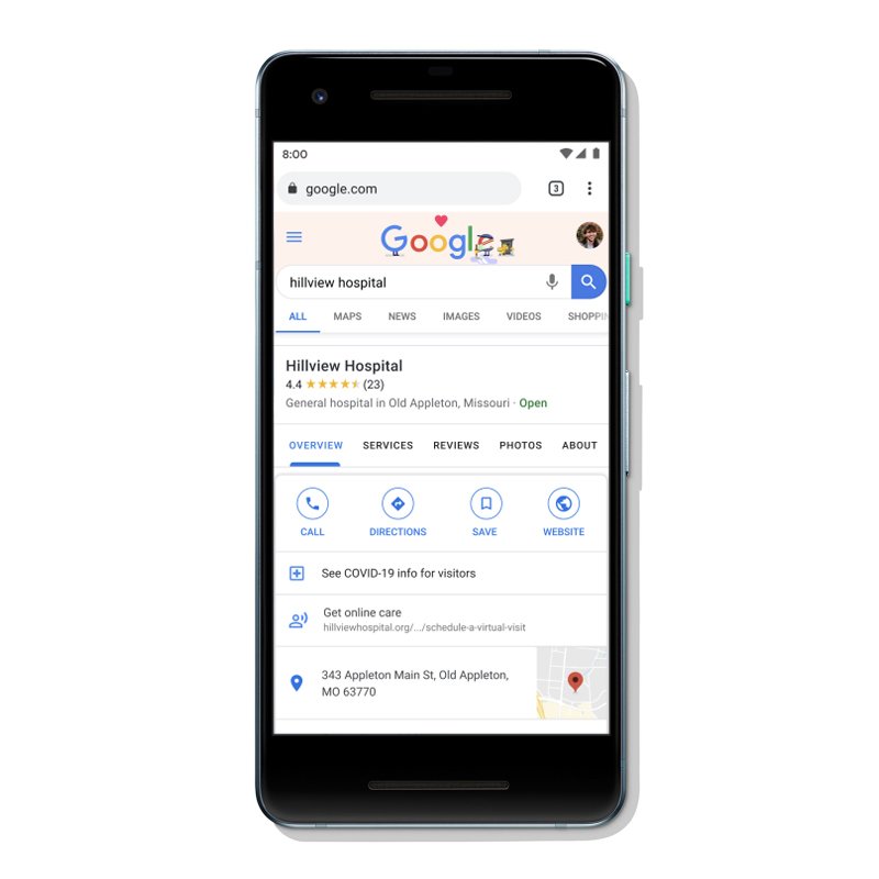
With health providers limiting in-person visits due to COVID-19, we’re making it easier for people to discover virtual care options.
Find virtual healthcare, anywhere, anytime
Beginning as a pilot in the U.S., we’ll also begin showing widely-available virtual care platforms directly on Search so people can more easily access virtual visits. For example, when people search for “immediate care”, we’ll be able to also present available virtual care options and related information such as the out-of-pocket price charged for a visit (for those without insurance) and an easy way for people to directly connect with the virtual care platform. The visit between the patient and provider will take place on the healthcare provider’s platform of choice.
People will be able to see widely-available virtual healthcare platforms directly on Search as well as the out-of-pocket cost for a visit.
For healthcare providers, helping you keep up with demand
In addition to helping healthcare providers with information about how to keep their online business information up-to-date, Google Cloud is supporting providers with technology infrastructure and solutions to assist with care delivery and operations. This includes helping doctors support patients remotely with HIPAA-compliant G Suite products (including using Google Meet for telehealth or virtual visits),deploying virtual agents to field questions related to COVID-19, and helping with capacity-planning and demand forecasting of key medical supplies to better manage their supply chains.
The global COVID-19 pandemic and the response to prevent its spread has changed the way individuals access and connect to health care. Across our products, we’ll continue to ensure that healthcare providers have the tools to connect with patients, and that anyone can access the information and care they need to stay healthy.
Connecting people to virtual care options
by Julie on Apr.10, 2020, under 3D Models, Argentina, Australia, Brazil, California, Denmark, England, Germany, Google Earth News, Google Earth Tips, Google Sky, Google maps, Hawaii, Indonesia, Ireland, Italy, Japan, Kenya, Mexico, Natural Landmarks, Netherlands, Sightseeing, Street Views, USA
To prevent the spread of COVID-19, many healthcare providers are reducing or stopping in-person visits for a variety of patient needs, from the treatment of chronic conditions to mental health services to evaluating cough and cold symptoms. Yet, people need a way to continue getting medical care from the comfort and safety of their own homes. Since the beginning of the pandemic, we’ve seen interest in virtual care and telehealth rise dramatically. Health consultations over the phone or by video conference not only help alleviate strain on doctors’ offices and emergency rooms but are also recommended as an important way to protect patients and staff against COVID-19.
To help individuals and health care providers connect, we’re focused on providing individuals with access to high-quality and authoritative information and supporting them throughout their health journey. Over the coming week, we’re beginning to roll out two new features in Search and Maps that make it easier for people to connect to virtual healthcare options, whether it’s to a doctor’s office down the street, the hospital across town, or a national telehealth platform.
Local healthcare providers, now virtual
Healthcare providers like hospitals, doctors, and mental health professionals can now enter a virtual care offering in their Business Profile, so that people searching for their local provider, for instance, might see a “get online care” link on Search and Maps. Clicking this link will take people to that provider’s virtual care website where they can find more information, and in many cases, schedule a virtual healthcare visit with a provider.
The pandemic has affected many healthcare providers’ operating hours and walk-in visit policies. To help communicate changes that might affect someone’s visit, we’re automatically surfacing a link directly to health providers’ COVID-19 information page on Search and Maps, and we've assembled best practices on how healthcare providers can update their websites and provide COVID-19 information on Google My Business.
With health providers limiting in-person visits due to COVID-19, we’re making it easier for people to discover virtual care options.
Find virtual healthcare, anywhere, anytime
Beginning as a pilot in the U.S., we’ll also begin showing widely-available virtual care platforms directly on Search so people can more easily access virtual visits. For example, when people search for “immediate care”, we’ll be able to also present available virtual care options and related information such as the out-of-pocket price charged for a visit (for those without insurance) and an easy way for people to directly connect with the virtual care platform. The visit between the patient and provider will take place on the healthcare provider’s platform of choice.
People will be able to see widely-available virtual healthcare platforms directly on Search as well as the out-of-pocket cost for a visit.
For healthcare providers, helping you keep up with demand
In addition to helping healthcare providers with information about how to keep their online business information up-to-date, Google Cloud is supporting providers with technology infrastructure and solutions to assist with care delivery and operations. This includes helping doctors support patients remotely with HIPAA-compliant G Suite products (including using Google Meet for telehealth or virtual visits),deploying virtual agents to field questions related to COVID-19, and helping with capacity-planning and demand forecasting of key medical supplies to better manage their supply chains.
The global COVID-19 pandemic and the response to prevent its spread has changed the way individuals access and connect to health care. Across our products, we’ll continue to ensure that healthcare providers have the tools to connect with patients, and that anyone can access the information and care they need to stay healthy.
Helping public health officials combat COVID-19
by Jen Fitzpatrick on Apr.03, 2020, under 3D Models, Argentina, Australia, Brazil, California, Denmark, England, Germany, Google Earth News, Google Earth Tips, Google Sky, Google maps, Hawaii, Indonesia, Ireland, Italy, Japan, Kenya, Mexico, Natural Landmarks, Netherlands, Sightseeing, Street Views, USA
As global communities respond to the COVID-19 pandemic, there has been an increasing emphasis on public health strategies, like social distancing measures, to slow the rate of transmission. In Google Maps, we use aggregated, anonymized data showing how busy certain types of places are—helping identify when a local business tends to be the most crowded. We have heard from public health officials that this same type of aggregated, anonymized data could be helpful as they make critical decisions to combat COVID-19.
Starting today we’re publishing an early release of our COVID-19 Community Mobility Reports to provide insights into what has changed in response to work from home, shelter in place, and other policies aimed at flattening the curve of this pandemic. These reports have been developed to be helpful while adhering to our stringent privacy protocols and policies.
The reports use aggregated, anonymized data to chart movement trends over time by geography, across different high-level categories of places such as retail and recreation, groceries and pharmacies, parks, transit stations, workplaces, and residential. We’ll show trends over several weeks, with the most recent information representing 48-to-72 hours prior. While we display a percentage point increase or decrease in visits, we do not share the absolute number of visits. To protect people’s privacy, no personally identifiable information, like an individual’s location, contacts or movement, is made available at any point.
We will release these reports globally, initially covering 131 countries and regions. Given the urgent need for this information, where possible we will also provide insights at the regional level. In the coming weeks, we will work to add additional countries and regions to ensure these reports remain helpful to public health officials across the globe looking to protect people from the spread of COVID-19.
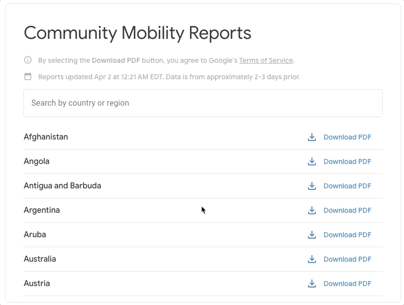
Navigate and download a report for your region of interest
In addition to other resources public health officials might have, we hope these reports will help support decisions about how to manage the COVID-19 pandemic. For example, this information could help officials understand changes in essential trips that can shape recommendations on business hours or inform delivery service offerings. Similarly, persistent visits to transportation hubs might indicate the need to add additional buses or trains in order to allow people who need to travel room to spread out for social distancing. Ultimately, understanding not only whether people are traveling, but also trends in destinations, can help officials design guidance to protect public health and essential needs of communities.
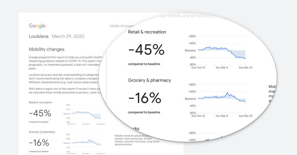
A Community Mobility Report example for State of Louisiana, United States
In addition to the Community Mobility Reports, we are collaborating with select epidemiologists working on COVID-19 with updates to an existing aggregate, anonymized dataset that can be used to better understand and forecast the pandemic. Data of this type has helped researchers look into predicting epidemics, plan urban and transit infrastructure, and understand people’s mobility and responses to conflict and natural disasters.
Privacy protections
The Community Mobility Reports are powered by the same world-class anonymization technology that we use in our products every day. For these reports, we use differential privacy, which adds artificial noise to our datasets enabling high quality results without identifying any individual person.
The insights are created with aggregated, anonymized sets of data from users who have turned on the Location History setting, which is off by default. Users who have Location History turned on can choose to turn the setting off at any time from their Google Account, and can always delete Location History data directly from their Timeline.
These are unprecedented times and we will continue to evaluate these reports as we get feedback from public health officials, civil society groups, local governments and the community at large. We hope these insights will add to other public health information that will help people and communities stay healthy and safe.
Helping public health officials combat COVID-19
by Jen Fitzpatrick on Apr.03, 2020, under 3D Models, Argentina, Australia, Brazil, California, Denmark, England, Germany, Google Earth News, Google Earth Tips, Google Sky, Google maps, Hawaii, Indonesia, Ireland, Italy, Japan, Kenya, Mexico, Natural Landmarks, Netherlands, Sightseeing, Street Views, USA
As global communities respond to the COVID-19 pandemic, there has been an increasing emphasis on public health strategies, like social distancing measures, to slow the rate of transmission. In Google Maps, we use aggregated, anonymized data showing how busy certain types of places are—helping identify when a local business tends to be the most crowded. We have heard from public health officials that this same type of aggregated, anonymized data could be helpful as they make critical decisions to combat COVID-19.
Starting today we’re publishing an early release of our COVID-19 Community Mobility Reports to provide insights into what has changed in response to work from home, shelter in place, and other policies aimed at flattening the curve of this pandemic. These reports have been developed to be helpful while adhering to our stringent privacy protocols and policies.
The reports use aggregated, anonymized data to chart movement trends over time by geography, across different high-level categories of places such as retail and recreation, groceries and pharmacies, parks, transit stations, workplaces, and residential. We’ll show trends over several weeks, with the most recent information representing 48-to-72 hours prior. While we display a percentage point increase or decrease in visits, we do not share the absolute number of visits. To protect people’s privacy, no personally identifiable information, like an individual’s location, contacts or movement, is made available at any point.
We will release these reports globally, initially covering 131 countries and regions. Given the urgent need for this information, where possible we will also provide insights at the regional level. In the coming weeks, we will work to add additional countries and regions to ensure these reports remain helpful to public health officials across the globe looking to protect people from the spread of COVID-19.
Navigate and download a report for your region of interest
In addition to other resources public health officials might have, we hope these reports will help support decisions about how to manage the COVID-19 pandemic. For example, this information could help officials understand changes in essential trips that can shape recommendations on business hours or inform delivery service offerings. Similarly, persistent visits to transportation hubs might indicate the need to add additional buses or trains in order to allow people who need to travel room to spread out for social distancing. Ultimately, understanding not only whether people are traveling, but also trends in destinations, can help officials design guidance to protect public health and essential needs of communities.
A Community Mobility Report example for State of Louisiana, United States
In addition to the Community Mobility Reports, we are collaborating with select epidemiologists working on COVID-19 with updates to an existing aggregate, anonymized dataset that can be used to better understand and forecast the pandemic. Data of this type has helped researchers look into predicting epidemics, plan urban and transit infrastructure, and understand people’s mobility and responses to conflict and natural disasters.
Privacy protections
The Community Mobility Reports are powered by the same world-class anonymization technology that we use in our products every day. For these reports, we use differential privacy, which adds artificial noise to our datasets enabling high quality results without identifying any individual person.
The insights are created with aggregated, anonymized sets of data from users who have turned on the Location History setting, which is off by default. Users who have Location History turned on can choose to turn the setting off at any time from their Google Account, and can always delete Location History data directly from their Timeline.
These are unprecedented times and we will continue to evaluate these reports as we get feedback from public health officials, civil society groups, local governments and the community at large. We hope these insights will add to other public health information that will help people and communities stay healthy and safe.